
Animal Carvings in British Churches
London: Cambridge University Press, 1938. Illustrated. 99 pages. Slim 8vo, stamped red cloth, missing dust wrapper. London: Cambridge University Press, 1938. A very good(+) copy. More
London: Cambridge University Press, 1938. Illustrated. 99 pages. Slim 8vo, stamped red cloth, missing dust wrapper. London: Cambridge University Press, 1938. A very good(+) copy. More
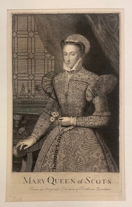
Print. Mezzotint with engraving. Image measures 11 1/2" x 7", Sheet measures 18 3/4"x 12 1/2" First state of this early 18th century mezzotint after an original painting by Frederico Zucchero (c. 1542-1609), an Italian painter and draughtsman. Depicts Mary Stuart, or Mary I of Scotland, who reigned from 1542 to 1567. A three-quarter length portrait, she holds a spray of roses in her left hand, and her right hand rests on the arm of a chair. Possibly published by..... More
New York: Macmillan, 1976. 16 pages of color photographs, and 120 black & white illustrations. 160 pages. Slim 4to, green cloth, d.w. New York: Macmillan, (1976). Top page margins just a touch wavy, still a very good(+) copy in a very good(+) dust wrapper. More
1 map. 179 pages, short 4to, printed wrappers with clear plastic outer wrapping. Photocopy facsimile reproduction of the London: John Murray, 1923 edition. More
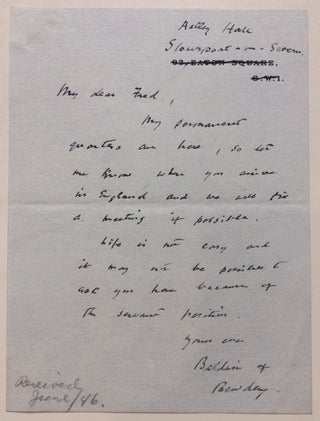
1946. A.L.S. "Baldwin of Bewdley", 8vo. 1 page, Ashley Hall, June 1946, to international attorney and political powerbroker Frederick R. Coudert, soon after the death of his wife and while stricken with sever arthritis and near total deafness, in full: "My permanent quarters are here, so let me know when you are in England and we will try a meeting if possible. Life is not easy and it may not be possible to ask you here because of the servant..... More
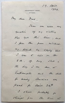
Ottawa, Canada: 1939. 2 pages (front and back), 8 x 5 inches, Government House, Ottawa, April 19, 1939. Written to powerful New York attorney Frederic R. Coudert during a lecture tour of Canada, in part: "...Nothing is settled yet and I will try and send you a line from Toronto if I have made any final arrangements while I am here. I only came over to give off these lectures which I hoped might be of use in Canada at..... More
New York: Villard, 1985. Illustrated. xii + 221 pages, 8vo, blue cloth-backed boards, d.w.; several tears to dust wrapper. New York: Villard Books, (1985). A very good copy in a very good(-) dust wrapper. More
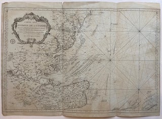
Paris: Jacques Nicolas Bellin, 1769. Sea Chart. Copper plate engraving with original hand coloring. Image measures 22.5" x 34". Includes depth measurements and rhumb lines as well as inland cities and geographical features. Some chipping and minor tears along bottom edge. Right margin missing. Jacques Nicolas Bellin (1703-1772), was the official hydrographer to the French king and the first person to hold the title of "Ingénieur de la Marine of the Depot des cartes et plans de la Marine" (chief..... More
lond: Random House, 2007. Illustrated in black & white and color. 255 pages. 4to, pictorial boards, d.w. London: Random House, 2007. Fine. More
New York: HarperCollins, 2021. Illustrated. xviii + 440 pages, 8vo, boards, d.w. New York: HarperCollins, (2021). First edition. A fine copy in a fine dust wrapper. More
New York: St. Martin's, 1973. Illustrated. 268 pages, 8vo, blue cloth, d.w. New York: St. Martin's Press, (1973). A very good copy in a very good dust wrapper. More
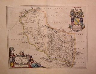
Amsterdam: 1634. Map. Engraving with original hand coloring. Image measures 16.5" x 20.5", page measures 21.5 x 25.75". Rare example from Spanish edition of "Theatrum Obis Terrarum" published in 1634. Shows section of Southern Uplands. Willem Blaeu (1571-1638) was a prolific Dutch mapmaker who started one of the most famous map publishing firms of the 17th century. It was at this time that the Dutch controlled the map trade, and their ornate and beautiful maps had immense popularity. Blaeu was..... More
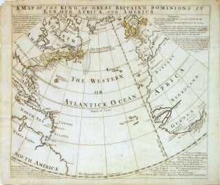
London: Bowen, Emanuel. Map. Engraving with color outline. Image measures 14 9/16" x 17 5/16". Scarce antique map of the Atlantic Ocean printed in 1740. It shows the English empirical reaches on a circular projection. Showing the eastern coasts of North and South America, the West Indies, Great Britain, Spain and Portugal and part of France, Morocco and the western coast of Africa. In North America the map names Nova Scotia, New England, New York, Pennsylvania, Maryland, New Jersey, Virginia..... More
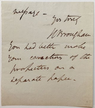
1820. 1 page, 5 x 4.5 inches, no place, no date, circa 1820 -- a conclusion of a handwritten letter with a postscript (but complete in itself), in full: "Yours Truly, H. Brougham. You had better make your corrections of the proportion on a separate paper." Boldly signed and in near fine condition. British statesman and Lord Chancellor. He also designed the One Horse Brougham. More
1826. Exceptional content A.L.S. 8vo. 4 pages (two separate leaves), April 15th 1826, in part: "...It is my intention to incorporate the Irish and Scottish Baronets in the next year's edition of the Peerage - and they are not to be found in Delbert's or any other works. I have procured Playfairs Baronetage, which give an account of their families up to 1810. After that period the necessary information must be had from the individuals themselves..." *Prior to 1827 Irish..... More
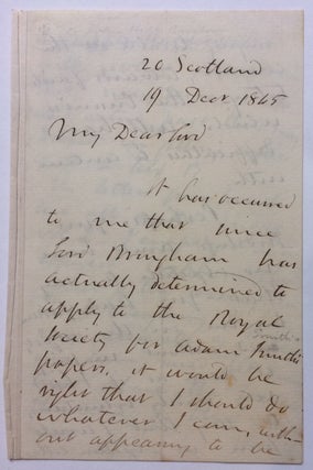
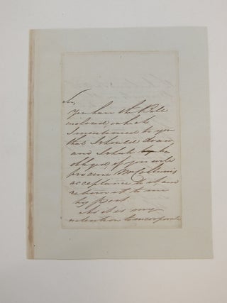
1865. A.L.S., 8vo. 4 pages, 20 Scotland Road, December 19, 1865, to Lord Murray of the Royal Society in reference to Lord Mayhem's use of Adam Smith's papers, in part: "...it has occurred to me that since Lord Mayhem has actually determined to apply to the Royal Society...it would be right that I should do whatever I can without appearing to be bringing trouble to the council, towards facilitating the cronies, which will have difficulties to contend with. Perhaps your..... More
New York: Random House, 1998. xii + 304 pages, 8vo, black cloth-backed boards, d.w. New York: Random House, (1998). First U.S. Edition. A fine copy in a near fine dust wrapper. More
New York: St. Martin's, 1979. Illustrated in black and white. 340 pages. 8vo, black cloth-backed boards, d.w. (chipped at front). New York: St. Martin's Press, (1979). Ownership signature at front free endpaper, page edges lightly spotted -- internally clean and tight. A very good copy in a very good dust wrapper. More
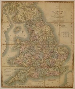
London: John Cary, 1818. Case map. Engraving mounted on linen, with original hand coloring. Image measures 29.75" x 24.75". Beautifully detailed case map of England, Wales and part of Scotland. Shows sailing paths and distances and major land routes, distinguishing between mail coach roads and stage coach roads. Minor overall wear, particularly to linen along original folds. A small stain near compass rose. Original case is intact, but worn. John Cary (1754-1835) was a British cartographer and engraver. His highly..... More
London: Chatto & Windus, 2000. Illustrated. 272 pages, 8vo, maroon cloth, d.w.; pages uniformily toned. London: Chatto & Windus, (2000). A very good(+) copy in a very good(+) dust wrapper. More
New York: William Morrow, 1962. Illustrated with black & white photographs and maps. 216 pages, 8vo, black cloth (spine ends faded), d.w. (price clipped, chipped and faded). New York: William Morrow & Co., 1962. Very good in very good(-) dust wrapper. A controversial account of the leaders of the British Expeditionary Forces in France, 1915. More
New York: New York Review of Books, 2012. Illustrated. 448 pages. 8vo, grey boards, d.w. New York: New York Review of Books, 2012. Some underlining in pencil and some pages dogeared, else a very good(+) copy in a near fine dust wrapper. More
New York: John Day, 1968. Illustrated. 171 pages, 8vo, blue cloth, d.w.; dust wrapper price clipped, closed tear to front cover. New York; The John Day Company, (1968). First American edition. A very good(+) copy in a very good dust wrapper. More
London: William Tegg, 1860. Revised and edited by his son, T. F. Dillon Croker. With additional illustrations by F. W. Fairholt 256 pages, 12mo, half brown polished calf over marbled boards. London: William Tegg, 1860. A very good(+) copy. Thomas Crofton Croker was an Irish antiquary interested in the legends, songs, and music of Ireland. More
New York: St. Martin's, 1973. xiii + 288 pages, 8vo, red cloth, d.w.; minor foxing to foredge, dust wrapper faded at spine with minor edgewear. New York: St. Martin's Press, (1973). A very good(+) copy in a very good dust wrapper. Modern British Foreign Policy. More
Hello. Many thanks for the 2 volumes which arrived this morning. They are outstanding examples of this scarce chess periodical and I am very pleased with them.
Got the books today! Wow the best wrapped, quickest delivery in the history of transtlantic book transport. If I had a hat it would now be removed, Muchas gracias