
Krushchev of the Ukraine: a Biography.
New York: Philosophical Library, 1957. 8vo, blue cloth. New York: Philosophical Library, (1957). vg. More
New York: Philosophical Library, 1957. 8vo, blue cloth. New York: Philosophical Library, (1957). vg. More
Kiev: Academy of Sciences of the Ukranian, 1969. Filled with maps, photographs, tables, and charts. 572pp., tall 8vo, green cloth. Kiev: Academy of Sciences of the Ukranian S. S. R., (1969). More
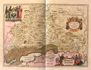
Amsterdam: Johannes Blaeu. Map. Copper plate engraving with original hand coloring with highlights in gold. Image measures 15.25" x 21". This beautiful circa 1650 map by Johannes Blaeu depicts southern Russia in detail. Covering the southwest part of Russia and Eastern Ukraine, the map extends from Vologda south to the Sea of Azov and from Mykolaiv east to the Volga River, where it discharges into the Caspian Sea. Throughout, the map notes rivers, towns, cities, lakes, and a host of..... More
Amsterdam. Map. Engraving with hand outline. Image measures 15" x 19 11/16". Beautiful map of Ukraine showing the area north of the Black Sea including Moscow, circa 1630. Latin text on verso. Willem Blaeu (1571-1638) was a prolific Dutch mapmaker who started one of the most famous map publishing firms of the 17th century. It was at this time that the Dutch controlled the map trade, and their ornate and beautiful maps had immense popularity. Blaeu was instrumental in driving..... More
Berlin: Springer, 1991. 124 illustrations, 47 tables. xxiii + 367pp., 8vo, illustrated boards. Berlin: Springer, (1991). A fine copy. More
Milan: Italgeo, 1950. Small card portfolio atlas, 13 x 9 1/2 inches. Patterned in green with brown title label and brown cloth spine. 19 color lithographs. In very good condition. Special edition Farmitalia: Milan, 1950. Special edition of Nicouline's pictorial masterpiece of 19 maps, one of all of Italy and 18 of the regions. Card wrappers titled to upper cover, historical notes and geographical descriptions of the area. Playful advertisements printed in color for Farmitalia, also by Nicouline. Maps loosely..... More
New York: Fortune, 1941. Original map. Color Lithograph. 13 7/8" x 22 3/8" Artistically rendered map of the Soviet Union drawn by Richard Edes Harrison in May 1941. The map is drawn on a globular projection, with the terminator line (or twilight zone) depicted along the eastern border with Germany, with a notation describing the time of day - "when dawn breaks at 5:30 over the Carpathians, it is 8:00 in the Urals, noon at Vladivostok, and 4:30pm at the..... More
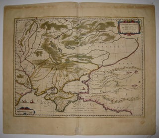
Amsterdam: Jansson, J. Map. Hand colored engraving. Image measures 14.1/2" x 18 3/4". This impressive map of the Black Sea and the Crimean Peninsula with its surrounding regions dates to circa 1650. Covers parts of the Ukraine, Russia, Georgia, Romania and Turkey. The map displayed detailed geographical and topographical features with mountains and forests beautifully rendered. Ships can be seen sailing in the Black Sea. A beautiful title cartouche adorns the right center. Published in Jan Jansson's historical atlas, based..... More
Amsterdam: Jocus Hondius. Map. Uncolored engraving. Image measures 12.25" x 15.75". Beautiful impression of Ukraine showing the area north of the Black Sea including Moscow, circa 1620. Nicely detailed geographic features. Latin text on verso. Overall toning. Full original margins. Small tear to bottom left edge. Mercator (1512-1594) was an accomplished mathematician, cartographer, globe maker and engraver but is best known for the Mercator Projection. Incorporating the newly accepted fact that the world is round, Mercator was able to render..... More
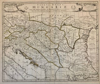
London: 1695. Map. Engraving with outline coloring. 17 1/2 x 21 1/4 inches, sheet measures 20 1/8 x 23 1/2 inches. Scarce map of Hungary and surrounding regions including Ukraine, Romania, Balkans as far west as Koningratz and Prague. Robert Morden (c.1650-1703) was a geographer, publisher, bookseller, and globe maker who collaborated with many other publishers in particular Thomas Cockerill to produce high quality atlases and maps (Burden 519-524). More
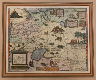
Antwerp: Ortelius, Abraham, 1608. Map. Engraving with beautiful hand coloring. Image measures 14" x 17.5". Gold frame with empire matting 22 1/2 x 25 1/2 inches. Exquisite circa 1608 map of western Russia from the Baltic States, shows the Gulf of Finland, to just beyond the Ob' River in Western Siberia. Includes the Caspian Sea. Richly decorated with folkloric vignettes with descriptions of obscure religious rites to match. Compilation map based on travel accounts. From "Theatrum Orbis Terrarum". Not examined..... More
New York: Columbia University Press, 1986. Translated, Annotated and with Introductory Essays by Philip Pomper. Russian Text Annotated by Yuri Felshtinsky. Illustrated sparsely in black and white. vii, 175 pages. Slim 8vo, red cloth, d.w. (lightly rubbed). New York: Columbia University Press, 1986. A fine copy in a very good(+) dust wrapper. More
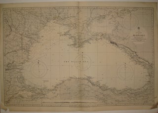
London: 1880. Sea chart. Uncolored engraving. Image measures 24.5" x 37.75". Beautiful map of the Black Sea based on Russian government surveys. Soundings in fathoms. Minor aging along edges. Expert repair to chip to lower left corner. Small tear to left edge. More
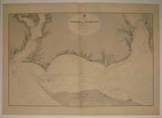
London: 1892. Sea chart. Uncolored engraving. Image measures 22 3/8" x 35.25". Beautifully detailed map of the coast line of Kherson Bay in the northern section of the Black Sea. Soundings in feet. Minor overall wear. More
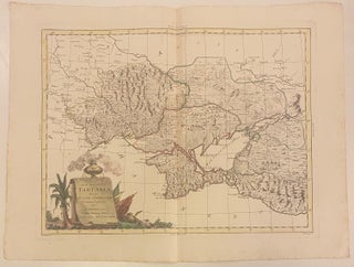
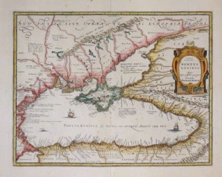
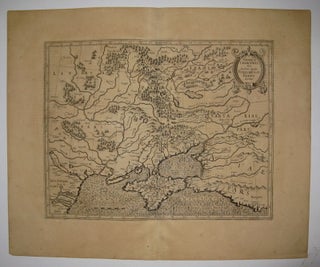
Venice: Antonio Zatta, 1783. Map. Engraving with original hand outline. Image measures 12 1/4" x 16" Nicely detailed map of the region comprising modern Ukraine and part of Russia. Centered on the Crimean Peninsula, the map extends from the Dnister River to the Caucasus Mountains. Hand-colored outline delineates regional divisions, reflecting ongoing military conflict between the Ottoman and Russian Empires. In good condition, with three small notations in manuscript noting the cities of Odessa, Vozia (incorrectly labeled), and Nikolajaw. Antonio..... More
Dear Argosy, I just finished watching TV. Now I know there is the old books store called Argosy in Manhattan, New York. I've been looking for first edition of Little Women written by Louisa May Alcott. Do you have it? If you do please let me know.
Dear Argosy: Thank you for your response. We have received the book in Japan with no problem. Thank you very much.