
Erziehungswesen in Ceylon, Israel und Nigeria: Bibliographie.
Frieburg: 1962. 45 pages. Short slim 4to, cloth-backed printed wrappers. Frieburg, 1962. Printed in offset. More
Frieburg: 1962. 45 pages. Short slim 4to, cloth-backed printed wrappers. Frieburg, 1962. Printed in offset. More
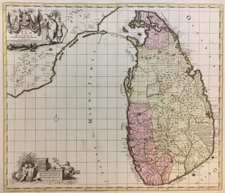
Map. Engraving with original hand coloring. Image measures 19 3/4 x 23 inches. Sheet measures 22 x 26 inches. Lovely map of Sri Lanka and part of India including Adams Bridge (limestone shoals between India and Sri Lanka, perhaps formerly constituting a land bridge also called Rama Setu) and two elegant cartouches. Staining throughout some toning otherwise good. Reiner and Joshua Ottens (1698-1750 and 1704-1765) took over their father's map-making business in 1725. They were known best for producing enormous..... More
New Haven: Yale University Press, 2004. Lavishly illustrated, often in color with multiple images. Large 4to, black cloth, d.w. New Haven: Yale University Press (2004). Fine in fine dust wrapper. More
Singapore: Times Editions, 1989. Hundreds of fine color photographs. Tall 4to, blue cloth, d.w. (Singapore): Times Editions, (1989). A fine copy in a near fine dust jacket. Presentation to Harry Belafonte on the half-title. More
Colombo: Ceylong Government, 1950. Translated into English by Wilhelm Geiger, assisted by Mabel Haynes Bode. Addendum by G. C. Mendis. Frontis map. lxiii + 323 pages, 8vo, two-toned white and yellow cloth (quite rubbed, and spine well worn with chip along top edge of front cover). Colombo: Ceylon Government Information Department, 1950. A good copy, rather ugly but with clean text clean. More
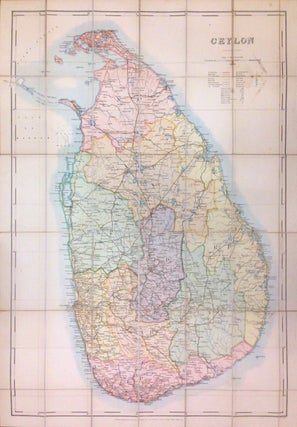
Ceylon: The Survey Office, 1910. Pocket map. Dissected and lined with linen. Map measure 38.5" x 27". This large folding pocket map issued by the survey office of Ceylon was published in 1910 under the orders of Mr. R. S. Templeton who was the Surveyor General of Ceylon from 1910 - 1915. The map covers the entire island and is color coded according to provinces. Notes roads, railways, towns, rivers, lakes, and a host of other topographical features. The map..... More
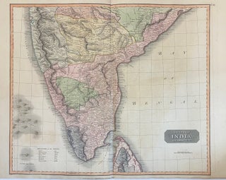
Edinburgh: John Thomson, 1816. Map. Engraving with original hand coloring. Image measures 20" x 23 3/4", sheet measures 20 7/8" x 27 3/4" This beautiful map of southern India, covering the region from Bombay to Chilika Lake, and southward to Cape Comorin and the Gulf of Manara, including part of Ceylon. The hand coloring indicates regions designated as 'British India' and Indian Rajah territories. Includes place names, rivers, and topograpical features. Topography is rendered by hachure. The map is dated..... More
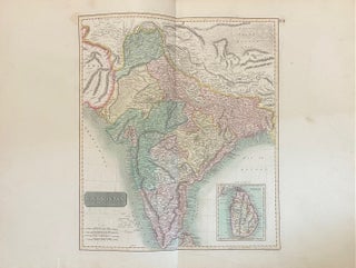
Edinburgh: John Thomson, 1817. Map. Engraving with original hand coloring. Image measures 18" x 15", page measures 21" x 28 1/4" A beautiful map of Hindoostan, or present-day India and Nepal with parts of Pakistan and Bangladesh, extending from Cabul and the Gobi Desert in the north, to Cape Comorin in the south, with an inset showing the Isle of Ceylon (Sri Lanka). Hand colored to show regions and kingdoms. Rivers and cities are extensively labeled, and relief is shown..... More
Got the books today! Wow the best wrapped, quickest delivery in the history of transtlantic book transport. If I had a hat it would now be removed, Muchas gracias
Dear Argosy, Today I received the letters and foto from Alma Tadema. My compliments for all the items plus information you also sent me. And I must say, I am very happy! Thanks you for the perfect shipping. I am very glad that I have bought the items by Argosy. Your website I keep in my favorite!