
Angewandte Bildungsokonomik: Das Beispiel des Senegal.
Munich: 1967. Tables. 8vo, printed wrappers. Munchen, (1967). Text in German. More
Munich: 1967. Tables. 8vo, printed wrappers. Munchen, (1967). Text in German. More
Paris: 1932. Map plus 9 Illustrations, 277pp, printed wrappers. Paris, (1932). Les Grandes Figures Coloniales, 9. More
Paris: 1950. Profusely Illustrated. 8vo, cloth-backed pictorial boards. Paris, 1950. More
Paris: 1968. Tall 8vo, pr. wrs. Paris, (1968). More
Stanford: Stanford University Press, 1971. Illustrated 8vo, cloth, d.w. Stanford: Stanford University Press, 1971. More
Stanford: Stanfor University Press, 1968. Illustrated sparsely with charts & maps. 285pp. 8vo, beige cloth, d.w. Stanford: Stanford University Press, 1968. A fine copy in a near fine dust wrapper. Published for the Hoover Institution on War, Revolution, and Peace. More
Paris: Jaques Collombat, 1695. [8], 9-213, [22] pages with text in French. Illustrated with 1 folding map (Brest Harbor) and 5 other engraved plates. Rubricated title page with engraved vignette. 12mo, full contemporary calf with blind-stamped covers and gilt spine (well-rubbed and spine chipped at foot; stain on front endpaper and gutter of title, which is also chipped at fore-edge; library giftplate on pastedown). Paris: Jaques Collombat, 1695. Rare. WITH a second softcover volume containing the English translation "Voyage to..... More
Garden City: 1943. 8vo, cloth (slight dampstain at bottom). 4 Illustrations. Garden City, (1943). More
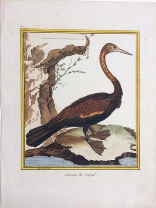
Engraving with hand coloring. 12.5 x 9.5 inches. Shows some light foxing. In very good condition. The Oriental darter or Indian darter is a water bird of tropical South Asia and Southeast Asia. It has a long and slender neck with a straight, pointed bill and, like the cormorant, it hunts for fish while its body is submerged in water. Francois-Nicolas Martinet (1731-1800) was a French engineer, naturalist, and engraver. More
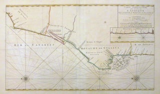
Amsterdam: Pierre Mortier, 1693. Map. Copper plate engraving with original hand coloring. Image measures 19.5 x 33". The large chart of the NW coast of Africa extends from Cape Boujdour south as far as the Senegal River, with the southern part of the coast depicted in an inset. Oriented to the left, it depicts the region of modern day Western Sahara, Mauritania and Senegal. The sea chart offers incredible detail along the coast noting towns, rivers, islands and coastal features..... More
Paris: Nathan, 1984. Illustrated in color. 107 pages. 4to, brown cloth, d.w. (small tear at spine). Paris: Nathan/Nea, (1984). Fine in a very good(+) dust wrapper. More

Portrait. Charcoal drawing on paper. Title is written in ink in lower right corner. Sheet measures 11" x 8 1/2". Lovely sketchbook drawing of a Senegalese woman, attributed to the artist Allan Rohan Crite, but unsigned. More
Just a quick "thank you" for a well-packaged, quickly shipped title. I'll bookmark you for future purchases.
Just wanted to say thank you for a great book. It was in great condition (exactly as described) & was packaged well... Keep up the good work and we continue to buy online!