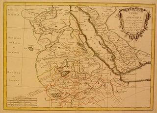
Nubie et Abissinie Projettee et assujettie aux observations Astronomiques.
Paris: Bonne, Rigobert, 1770. Map. Engraving with original hand coloring. Image measures 11.75" x 16.25". North East Africa including part of Egypt, Ethiopia, Somalia, Saudi Arabia, Eritrea and Yemen. Rigobert Bonne (1727-1795) was one of the most important cartographers of the late 18th century. He served as Hydrographer to France, and during his term, he produced a number of detailed and useful maps, particularly of coastal regions. His work is often devoid of decorative cartouches and compasses roses and marks..... More