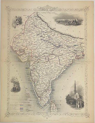
British India
London: John Tallis & Company, 1860. Map. Steel engraving with outline hand color. Page measures 13 7/8" x 10 5/8" Lovely map of India in the mid-19th century. Features four vignettes showing the Beloochee's; Lahore; Cootub Minar, Delhi (a world heritage site); and Indian Procession in the lower left with elephants. Hand colored to show proposed railroads connecting Bombay, Calcutta, and Delhi. Regions are also colored, representing the Presidencies of Madras, Calcutta, and Bombay; as well as territories controlled by..... More