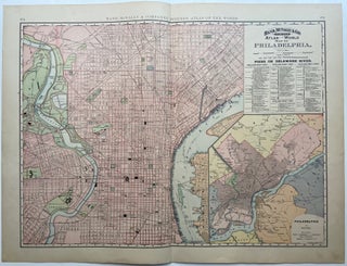
Map of Philadelphia
Chicago: Rand McNally & Co., 1894. Map. Lithograph. Sheet measures 21 7/8" x 29" This beautiful 1894 Rand McNally map depicts the city of Philadelphia in vivid color and wonderful detail, extending from Erie Avenue in North Philadelphia, including Fairmount Park and Port Richmond, to Moore Street in South Philadelphia. Map also depicts part of West Philadelphia and includes the waterfront of Camden, NJ. Streets, notable buildings, parks, railroads, and ferry routes are labeled. Piers along the Delaware River are..... More
