
The Incas; A Novel.
1060pp. 8vo, cloth, d.w. N.Y.: Random House, (1991). First Edition. vg. More
1060pp. 8vo, cloth, d.w. N.Y.: Random House, (1991). First Edition. vg. More
New York: Metropolitan Museum of Art, 2004. Extensively illustrated in color. xiii + 396 pages, large 4to, stiff glossy pictorial wrappers. New York: Metropolitan Museum of Art, (2004) Slight bump at bottom corners, else near fine. More
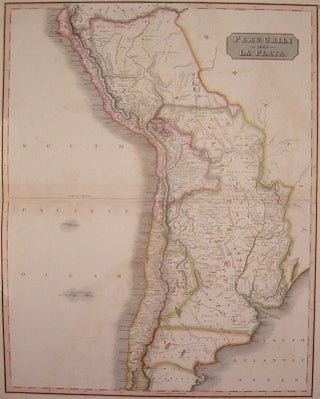
London: Cadell & Davies, 1817. Map. Engraving with hand coloring. Image measures 27 5/8" x 20". Beautiful large map of South America encompassing the southern tip of Peru, the northern half of Chile, parts of Bolivia and Brazil, Paraguay, Uruguay and much of Argentina including Buenos Aires. Extensive geographical, historical and ethnographic details. Very small chip to top right corner, otherwise in excellent condition. John Pinkerton (1758-1826) was a prominent English mapmaker known for his large and impeccably detailed maps..... More
New York: Dutton, 1978. Illus. 8vo, 1/2 brown cloth, d.w. lightly soiled, d.w. faded from sun exposure on spine, many pages slightly wavy. New York: Dutton, (1978). More
New York: Random House. Map. xxxvi, 1288pp. 8vo, 1/2 red cloth. New York: Random House, n.d., circa 1960. Very good. More
New York: Harper, 1847. Frontispiece in each volume, map of Peru, facsimile of two signatures of Pizarro. 2 volumes. 8vo, original brown blind-stamped cloth, spine ends and edges of corners worn, scattered foxing in both volumes including illustrations, foxing to yellow endpapers in both volumes, tear in margin of page 215 of volume II. New York: Harper, 1847. First Edition Laid in is a brief autographed letter, signed, by the author, William H. Prescott, presenting his signature to the owner..... More
New York: Heritage, 1957. Color illustrations. 8vo, gray cloth-backed pictorial boards, red board slipcase (worn). New York: Heritage Press, (1957). Very good(+) in good box. More
Philadelphia: Lippincott, 1875. 5 volumes, 8vo, 3/4 brown morocco, ornately gilt spines, marbled boards and endpapers. Philadelphia: Lippincott, 1875. A very nice clean set. More
Zurich: Museum Rietberg, 1999. Many illustrations. 380 pages with text in German. 4to, pictorial boards, rear cover lightly rubbed. Zurich: Musem Rietberg, (1999). Internally fine, a very good(+) copy. More
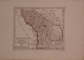
Paris: Robert de Vaugondy, 1749. Map. Engraving with modern hand outline. Image measures 6.25" x 7.5". Creases to upper left and lower right corners. Gilles Robert de Vaugondy (1688-1766) was an important French mapmaker during the 18th century. His "Atlas Universel" was one of the most significant atlases of the period, integrating older sources with more modern surveyed maps in order to convey correct geographical and political information. More
2 vols. 16mo, modern cloth, leather labels; (wood-pulp paper). Madrid, 1891. Author was the personal representative of the King of Spain in Peru. Facsimile of the 1681 edition. Palau XVII, 271818. More
Urbana: Krannert Art Museum, University of Illinois, 1975. Numerous photo Illus., several in color. Oblong 4to, pr. wrs. Urbana: Krannert Art Museum, University of Illinois, (1975). Fine Laid in a 1/2 brown morocco and tan cloth clamshell box. More
Greenwich: The Metropolitan Museum of Art, 1966. With drawings by Milton F. Sonday and photographs by William F. Pons and William E. Lyall. 144 pages, 4to, decorative tan cloth, dust wrapper (edge-worn). Greenwich: The Metropolitan Museum of Art in conjunction with the New York Graphic Society, (1966). A near fine copy in a very good dust wrapper. More
Berlin: Im Propylaen Verlag, 1929. Illustrated abundantly in color and in black and white. 622 pages. Large 8vo, 3/4 black leather over green gilt-stamped boards, red spine label with decorative gilding (edgeworn, rubbed at rear). Berlin: Im Propylaen Verlag, (1929). Internally clean and tight. Text in German. A very good(+) solid copy. More
London: Edward Stanford, 1857. Map. Engraving with original hand coloring. Image measures 12" x 15.5". Detailed map of the eastern coast of South America. The Society for the Diffusion of Useful Knowledge was formed in 1826 and published low cost maps with the goal of reaching a large market, while still maintaining high quality and precision. Small tear to left margin. More
Cleveland: World, 1961. 58 Illus., 4 in color. 8vo, original tan cloth, d.w. lightly soiled, ex-lib. Cleveland: World, (1961). More
Cleveland: World, 1961. 58 Illus., 4 in color. 8vo, tan cloth, small area of wear to bottom edge of back cover, otherwise very good. Cleveland: World, (1961). More
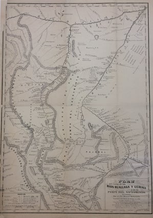
Baltimore: Hoen & Co, 1853. Map. Lithograph. Image size 15.25 x 11 inches. Sheet size 16 x 11.75 inches. Label verso from 'Peter Hertzog Theological Hall Library', a division of Rutgers University Library with manuscript notations 'The family of de De Van Frank'. Course plan for the Huallaga and Ucayali rivers and the Pampa del Sacramento, in Peru based on the travels of Father Manuel Sobreviela. A Key at lower left indicates towns populated by Christians, converts, and the unconverted..... More
many color photo. illus. by Hans Silvester. oblong 4to, cloth, d.w.; (d.w. chipped, otherwise vg). N.Y.: Viking, (1977). More
Durham: Duke, 1951. Illustrated. x + 247pp., 8vo, yellow cloth, d.w.; dust wrapper price clipped, chipped at spine ends and upper corners. Durham: Duke University Press, 1951. A very good (+) copy in a very good dust wrapper. More
109pp. 8vo, stitched; (uncut). Paris, 1851. First edition. An essay on the question of religious freedom for Peru. More
Madrid: Imprenta de Villalpando, 1798. de querer dexar la Ciudad de Mexico por pasar a la de Lima. Obra Jocosa y Divertida En que con salados conceptos se describen, ademas de otras cosas, las costumbres, usos y manas de las madamitas de alli, de aca y de otras partes. La da a luz Simon Ayanque [pseudonym]. xii, 192pp. 24mo, contemporary tree calf, leather spine label, gilt decorated spine, slight warp to upper 1/3 of spine and covers, edges of corners..... More
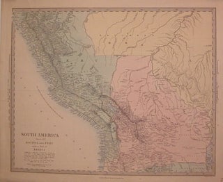
Philadelphia: Thomas, Cowperthwait & Co., 1850. Map. Engraving with original hand coloring. Image measures 12.25" x 15". Thomas, Cowperthwait & Co. took over publication of S. A. Mitchell's important "Universal Atlas" in 1850, and continued to produce updated maps that were considered some of the best commercial cartography of the 19th century. More
Chicago: Field Museum of Natural History, 1936. 12 plates, 18 text Illus., 1 map. 8vo, blue cloth, original wrappers bound in. Chicago: Field Museum of Natural History, 1936. Very good. More
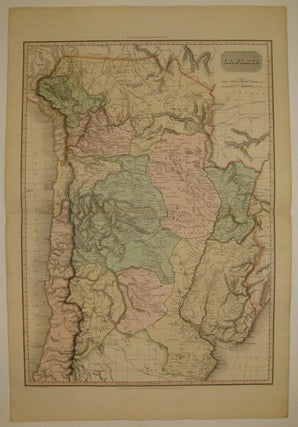
Edinburgh: John Thomson, 1817. Map. Engraving with beautiful original hand outline. Image measures 24.5" x 19.5". From Thomson's "New General Atlas" of 1816. Some minor foxing. More
Ben, got the book, it's fabulous!! Thanks, it was a pleasure doing business with you.
I write to you these few words to tanks for your friendly service and to notify the correct arrive in Rome of my two maps (New York and Paris). Tank you and good bye to my next visit in NY.