NEW ZEALAND

Te Maori: Maori Art from New Zealand Collections.
New York: Abrams, 1984. 60 color plates and 211 other illustrations; 6 maps. 244 pages. 4to, pictorial wrappers. New York: Abrams/American Federation of Arts, (1984). Near fine. Exhibition catalogue. More
New Zealand.
16mo, cloth, d.w. London, 1950. More
Nga Tohu Tawhito; Early Maori Ornaments
Auckland: David Bateman, 1999. Illus., most in color. 32pp. 8vo, pr. wrs. (Auckland): David Bateman, (1999). Very good Presentation copy. More
The Story of New Zealand.
Plates & Illus. 8vo, green cloth (faded; rubbed). Wellington, (1965). More
A Book of New Zealand.
Illus. 12mo, cloth, d.w. Glasgow, (1964). More
A Short Narrative of the Late Campaign of the British Army Under the Orders of the Right Honourable the Earl of Chatham, K.K. With preliminary remarks on the topography and channels of Zeeland.
London: James Ridgway, 1810. 2 large folding maps. 96 pages, with some off setting on title page. Slim 8vo, early brown-backed blue paper boards. London: James Ridgway, 1810. First Edition. Scarce. More
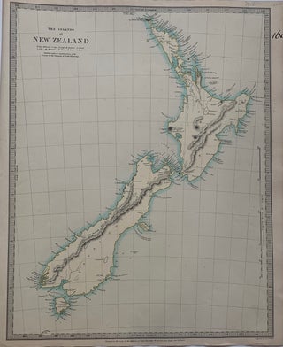
The Islands of New Zealand
London: Chapman and Hall, 1844. Map. Engraving. Sheet measures 16" x 13.5". Some light foxing and staining. In very good condition. This detailed map by the Society for the Diffusion of Useful Knowledge or SDUK depicts New Zealand. Incredibly detailed along the coastlines, the interiors are relatively unmapped, reflecting the lack of knowledge of the region. Features interesting notes such as High mountains said to be covered with perpetual snow, Supposed coal fields, and Lookers on appearance of a fine..... More
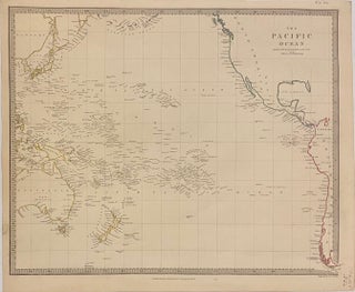
The Pacific Ocean
London: Charles Knight & Co., 1846. Map. Engraving. Image measures 12 1/2" x 15 1/2" This highly detailed map by the Society for the Diffusion of Useful Knowledge, or SDUK, depicts the Pacific Ocean. Island groups and coastlines are extensively labeled, while the interiors are relatively unmapped. Some Pacific islands are labeled with question marks, indicating uncertainty of their existence. The map is in excellent condition. The Society for the Diffusion of Useful Knowledge was formed in 1826 and published..... More
New Zealand. Pacific Pioneer.
Illustrated. 8vo, cloth (bookplate; torn dust wrapper). New York, 1946. More
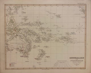
Australien und Polynesien in Mercators Projection
Gotha: Justus Perthes, 1850. Map. Engraving with hand outline coloring. Image measures 12" x 15" Incredibly detailed map in German of the Pacific Ocean, including Australia, Southeast Asia, and New Zealand. Island groups are extensively labeled, and hand coloring is used throughout to indicate colonial holdings. This map appeared in the 1853 issue of Stieler's Hand Atlas. In very good condition with minor spotting, and toning to margins - not affecting the image. The publishing firm of Justus Perthes (1749-1816)..... More
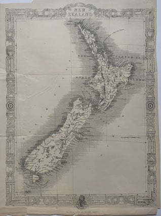
New Zealand
London: Tallis, John, 1851. Map. Steel engraving. 14 x 10 1/4 inches. Beautiful map of New Zealand without the typical vignettes. Tallis substitutes his usual decorative border for a traditional Maori pattern. In very good condition, with minor chips to margins. Folded as issued with several creases. John Tallis Jr. (1817-1876) was a London born bookseller who continued the prolific map publishing company started by his father. After a partnership with his brother, Tallis Jr. expanded the business to New..... More
Nawok! The New Zealand Expedition to New Guinea's Highest Mountains.
London: Dent, 1962. Color frontis., illustrated with black and white photographs and maps. xiii + 189pp., 8vo, black cloth; lightly rubbed, very faint dampstain to front and rear covers near the spine. London: J.M. Dent & Sons, 1962. First edition. A very good copy. More
A Distant Music: The Life & Times of Alfred Hill 1870-1960
Auckland: Oxford University Press, 1980. With b/w illustrations throughout. vi, 239pp. 8vo, burgundy cloth (a bit edgeworn), d.w. Auckland: Oxford University Press, (1980). A near fine copy in a near fine dust wrapper. More
The Call of the Southern Cross: Being Impressions of Four Months' Tour in Australia and New Zealand.
3 Illustrations. 16mo, gilt-stamped green cloth. London, (1932). A very good(+) bright copy. More
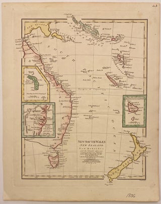
New South Wales, New Zealand New Hebrides and the Islands adjacent
London: Robert Wilkinson, 1806. Map. Engraving with hand coloring. Image measures 12" x 9 1/2" This lovely map depicts the eastern coast of Australia, the southern tip of Papua New Guinea, the Solomon Islands, Vanuatu, New Caledonia, and New Zealand. Insets show Lord Howe Island, Norfolk Island, and Port Jackson with its Environs. Robert Wilkinson (d. 1825), was a London based map and printseller who collaborated with John Bowles and others to produce high quality maps and atlases... More