
The Boer War: London to Ladysmith via Pretoria: Ian Hamilton's March.
New York: Dorset Press, 1991. 405pp. 8vo, two-toned cloth, d.w., cloth covers slightly warped, otherwise very good. New York: Dorset Press, (1991). More
New York: Dorset Press, 1991. 405pp. 8vo, two-toned cloth, d.w., cloth covers slightly warped, otherwise very good. New York: Dorset Press, (1991). More
London: Longmans, 1898. Frontispiece portrait & 6 maps, 4 folding. original green cloth, gold-stamped the the front cover & spine. London: Longmans Green, 1898. First Edition. Churchill's scarce first book. There is light foxing throughout; the original black front end-paper is scuffed where a bookplate was removed; front fly-leaf starting to detach; ownership signature on half-title. Lack of errata slip & 12/97 on he 32p. catalogue in the back indicate a first state. More
New York: Viking, 1973. Edited with notes by Frederick Woods. Illustrated. 350 pages. Thick 8vo, green cloth, a bit stained on rear panel, d.w. New York: The Viking Press, (1973). Very good in very good dust wrapper. More
Norwalk: Easton, 1989. Volume 5 ONLY of the Second World War series. Thick 8vo, black leather gilt-decorated spine with raised bands & leather labels, all edges gilt. Norwalk: Easton Press, (1989). Fine. More
Norwalk: Easton, 1989. Volume 4 ONLY of the Second World War series. Thick 8vo, black leather gilt-decorated spine with raised bands & leather labels, all edges gilt. Norwalk: Easton Press, (1989). Fine. More
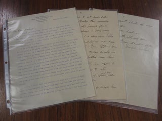
Cleveland: 1903. Typed letter to his daughters with a two-page handwritten continuation and signature. The letter concerns the rents his family has been charging tenants, in part: "...I am sorry we have to reduce rents but the only way to get along in this world is to adjust ourselves to the conditions as they are forced upon us. If a merchant holds up to high prices when everybody around him is making low prices he will soon be left without..... More
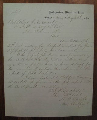
Galveston: 1866. Autographed letter signed "H.G. Wright" by the Major-General of the Union Army sent from his headquarter in Texas to a colleague in New Orleans regarding an update on an Inspection report. 1 page on lined, Headquarters, District of Texas letterhead. 4to. Galveston, Aug. 25, 1866. "...The report for June was forwarded...two or three days ago; its completion having been delayed for the correction of certain discrepancies in the reports of Dist. Inspectors..." More
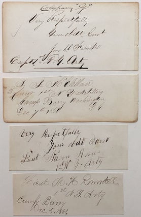
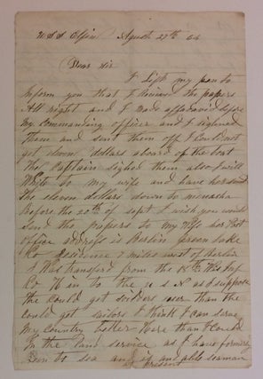
New York: 1861. Excellent group of signatures with rank and command, on various sized paper (the largest measuring 2.5 x 5 inches), comprising the earliest known autographs of the founding three officers of Battery G, First New York Light Artillery, along with the last Captain to take command through attrition. Includes: J.D. Frank "Very respectfully - Your Obdt. Servt. - Captain, 1st N.Y. Artillery"; M.H. Rundell "Lieutenant - 1st N.Y. Artillery - Camp Barry - Dec. 5th 1861"; Nelson Ames..... More
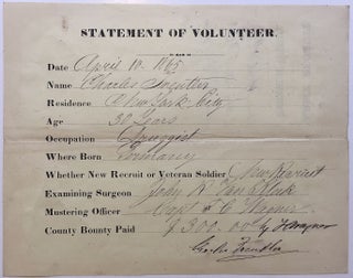
1865. On the day the war ends, a volunteer enlists in the Union Army and collects his $300 bounty! 1 page, 6.75 x 8.5 inches -- a Statement of Recruitment, whereby Freuter, a New York City druggist, age 30, is allowed to join the Union Army and receive his $300 bounty, on the very day the war has ended, April 10, 1865. Also signed by the Mustering Officer, Captain S. C. Wagner. Note: in the very last days of the..... More
1864. Union Navy A.L.S. 8vo. 2 pages, August 27th 1864, Aboard the USS Elfin. Just three months before she would be destroyed by bombardment while in service on the Tennessee & Cumberland Rivers. Letter from a sailor who is trying to get his Land Grant application to Wisconsin, but he can't raise the $11.00 application fee on his ship. In part: "I received the papers alright and I signed an affidavit before my Commanding Officer - and I signed them..... More
London: Allen & Co., 1963. Foreword by Sir Cecil S. Sugden. Illustrated. Tall 8vo, beige cloth. London: Allen & Co., (1963). First Edition. Near Fine. More
Paris: Jombert, 1749. Handsome copper-engraved vignette heading the Dedication and 36 folding plans. XXIV, 247pp. 4to, full contemporary calf with gilt spine (board well-worn with front cover detached; internally fine). Paris: Chez Charles-Antoine Jombert, 1749. First edition. First edition of this important work by the noted military engineer. Clairac acknowledges the genius of Marechal Vauban's work on fortification and assault and mathematically improves on earlier designs for fortification. Uncommon. -- Graesse II, 90; Jordan, 712. More
New York: Berkley Books, 1993. Many b/w illustrations throughout. xx, 328 pages. 8vo, black cloth-backed boards, d.w. New York: Berkley Books, (1993). First edition, first printing. Fine in fine dust wrapper. More
Oxford: Clarendon, 1826. 8 volumes. 8vo, bound in full tan calf with red and black spine labels and blind stamping, gilt-decorated crest on covers. Oxford: Clarendon Press, 1926. Very good(+). More
Oxford: Clarendon, 1819. Three volumes, bound in six. [4], 404; [4], 405- 964; [4], 613; [4], 615-989; [4], 635; [4], 637-1213, [59]pp. 8vo, contemporary polished calf; gilt-stamped spines with 2 black leather labels (leather is rubbed; joints neatly repaired on 3 volumes; 3 of the books are also missing 1 of the labels, but the text is still visible); marbled edges and endpapers. Oxford: Clarendon Press, 1819. Though the spines show wear the text black is clean and tight. Very..... More
New York: William Morrow, 1962. Illustrated with black & white photographs and maps. 216 pages, 8vo, black cloth (spine ends faded), d.w. (price clipped, chipped and faded). New York: William Morrow & Co., 1962. Very good in very good(-) dust wrapper. A controversial account of the leaders of the British Expeditionary Forces in France, 1915. More
London: Allen, 1852. 272, 163 [Madras], 145 [Bombay] pages plus ads. Very thick short 8vo, full calf, worn and with joints repaired. More
New York: Atlantic Monthly, 2016. Illustrated. xx + 457 pages, 8vo, black cloth-backed boards, d.w. New York: Atlantic Monthly, (2016). A near fine copy in a very good dust wrapper. More
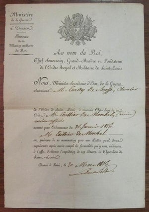
Paris: 1816. 1 page, 12.5 x 8 inches, Paris, March 20, 1816. This partly-printed document signed "Le Duc de Feltre" is an award of a military honor to a French soldier. Very good condition. French Marshall, private secretary to Napoleon during the Consulate, and Minister of War (1807-14) during Napoleon's campaigns. More
New York: Free, 2004. xiii + 304 pages, 8vo, cloth-backed boards, d.w. New York: Free Press, (2004). A fine copy in a near fine dust wrapper. More
New York: Free, 2004. xiii + 304 pages, 8vo, cloth-backed boards, d.w. New York: Free Press, (2004). A fine copy in a fine dust wrapper. More
Seattle: Superior Publishing Company. Illustrated in black and white. 176 pages. 4to, blue cloth with light blue lettering. Seattle: Superior Publishing Company, (n.d., ca. 1966). Rear cover is a bit stained, internally clean and tight. Very good. Reminiscences of a Private 1st Class who served in the 27th U.S. Division with the British Forces in Belgium and France. More
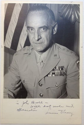
1950. 13 x 8.5 inches, no place, circa 1950. Fine black-and-white half-portrait photograph of the General in uniform. Inscribed on the wide bottom margin: "To John Bale with best wishes and appreciation, Lucius D. Clay." Very good condition. More
New York: Free Press, 2003. Illustrated in black and white. xiv, 368 pages. Tall 8vo, brown and orange boards, d.w. (spine sunned). New York: The Free Press, (2003). Near fine in a near fine dust wrapper. More
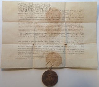
1790. 1 page, 14.5 x 21 inches, February 3, 1790, signed "Geo: Clinton" -- a grant for a parcel of land, lots # 65 and # 93, set apart by "Laws of this State for the Canadian and Nova-Scotia Refugees," issued to Revolutionary War General Moses Hazen, a tract of 500 acres in Clinton County, New York, with the original large pendant wax seal, 3.5 inches in diameter, wrapped in leather and affixed with twine at the lower edge. Moses..... More
Bountiful thanks! I just returned from a business trip, and the "Armenian Art Treasures of Jerusalem" book had arrived at my office in perfect condition. Thank you for your kindness and professional courtesy!
If there is a heaven, it looks a lot like your store. What a great place to spend an afternoon!