
Ancient Maya Relief Sculpture.
New York: Museum of Primitive Art, 1967. Rubbings by Merle Greene. 60 plates, map. Unpaginated. 4to, printed wrs., board slipcase. N.Y.: Museum of Primitive Art, 1967. More
New York: Museum of Primitive Art, 1967. Rubbings by Merle Greene. 60 plates, map. Unpaginated. 4to, printed wrs., board slipcase. N.Y.: Museum of Primitive Art, 1967. More
60 plates. 4to, pr. wrs., boxed. N.Y.: Museum of Primitive Art, 1967. vg. More
New York: Wiley and Putnam, 1846. x, 304pp. + 4pp. of pubisher's ads. 8vo, original brown cloth, spine ends and edges of corners worn, corners bumped, scattered light foxing, mostly to margins. New York: Wiley and Putnam, 1846. First Edition Author was United States' Minister to Mexico from 1842 to 1844. Author writes on Mexican politics and his impressions of Mexico. First edition with the dedication leaf. Palau 331864. Haferkorn page 87. Raines 204. Graff 4137. More
New York: Wiley and Putnam, 1846. x, 304pp. 8vo, modern cloth, moderate foxing throughout, first few pages with small dampstain to right margins. New York: Wiley and Putnam, 1846. Author was United States' Minister to Mexico from 1842 to 1844. Author writes on Mexican politics and his impressions of Mexico. Palau 331864. Haferkorn page 87. Raines 204. Graff 4137. More
illus. 8vo, cloth; (uncut): Glendale: Arthur H. Clark, 1967. First Edition. vg. More
New Mexico: University Press, 1993. Illustrated in black and white. 230 pages. 8vo, purple cloth, d.w. (spine sunned). Albuquerque: University of New Mexico Press, (1993). Near fine in a very good(+) dust wrapper. Translated by Elinor Randall. More
Mexico: Editorial RM, 2003. Illustrated in black and white. 359 pages. 8vo, two-toned boards, d.w. (lightly edgeworn). Mexico: Editorial RM, 2003. First Edition. Boards lightly soiled. Very good in a very good dust wrapper. Translated by Gregory Dechant. More
Austin: University of Texas, 1970. Illustrated. 332pp. 8vo, cloth-backed decorative boards. Austin: University of Texas, 1970. Near fine. More
Detroit: Blaine-Ethridge, 1973. Illustrated in b/w photos throughout. 107 pages + rear plates. Thin 8vo, gilt-decorated red cloth. Detroit: Blaine-Ethridge, 1973. Reprint of 1939 edition published in Mexico. A very good copy--light warping to lower edges of boards, some light foxing, Diego Rivera's name highlighted in yellow on copyright page. More
Mexico: Imprenta Universitaria, 1962. 448 illus. 303 pages. Thick 4to, gray cloth, sunned at edges. Mexico: Imprenta Universitaria, 1962. Second edition. Near fine, in a good dust wrapper -- soiled, sunned & a bit chipped. More
New York: Macmillan, 1907. in American Archaeology, 1902-1905. 29 plates, 49 text Illus. xx, 195pp. 8vo, contemporary 3/4 red morocco, spine and corners worn, edges of boards worn. New York: Macmillan, 1907. First Edition Internally, a tight bright copy. More
Cambridge: Peabody Museum, 1913. 23 plates, one folding. 54 text Illus. Folio, original pr. wrs., pages partially unopened, spine ends worn, wrappers chipped, front wrapper partially faded from sun exposure. Cambridge: Published by the Museum, 1913. First Edition Memoirs of the Peabody Museum of American Archaeology and Ethnology, Harvard University. Vol. V, No. 3. More
London: James Duncan, 1834. With an Excursion to the Island of Cuba. In a Series of Letters, Written in the Years 1831-2. 2 volumes. 8vo, original boards, original paper spine labels, spines expertly rebacked in modern cloth, page margins uncut, inner hinges strengthened in both volumes, boards worn on edges of corners and lightly soiled on both volumes, light foxing to title-page of volume II. London: James Duncan, 1834. First Edition "Travels (in the United States) extended from Maine to..... More
Chapel Hill: University of North Carolina Press. 8vo, red cloth. Univ. of NC Pr., 1968. More
New York: Macmillan, 1901. Several color plates, many b/w photo Illus., large color folding map. xii, 472pp. 8vo, original green cloth, lacks front flyleaf, ex-lib, edges of corners bumped and lightly worn, cloth rubbed, small chip to margin of Frontis. New York: Macmllian, 1901. First American Edition Folding map has several small tears in folds with some loss of text. There has been some repair to the map with tape on the blank side. More
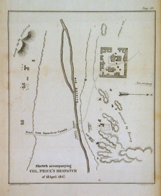
Washington D.C. Wendell and Van Benthuysen, 1847. Map. Uncolored engraving. Image measures 8.25" x 7.5". This battle plan depicts the route of the Col. Sterling Price's movements during the Mexican-American War on 18th April,1847 along the road from Santa Fe to Canada, near the Rio Chicito (Little Colorado River or Flax River). The movements of the army are clearly marked with topography beautifully depicted and enemy positions marked. It is in vey good condition with no chips with minor wear..... More
8vo, cloth, d.w. Univ. of NM Pr., (1970). More
Cozumel, Mexico: 1964. 1 page on onionskin typing paper (transferred pencil or charcoal smudges in right margin), 11 x 8.25 inches, Cozumel, Mexico, March 14, 1964. Written to President Aleman during a research trip, in large part: "...I have been traveling throughout your great country 'observing and learning' in preparation for my story. I am overwhelmed by your hospitality and by the warmth of the Mexican people whom I have come to love in a short time. I do hope..... More
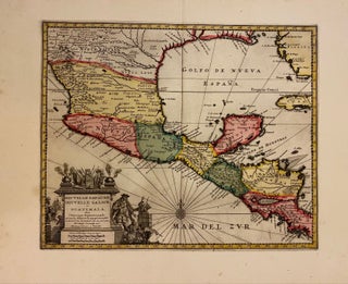
Leiden: Van der Aa, Pierre, 1729. Map. Engraving with full hand coloring. Image measures 11 1/2" x 14". Leiden: 1729. Finely engraved map of Mexico and Central America. Beautifully detailed, the map labels regions, towns, rivers, lakes, and coastal features. Mountains are depicted pictorially. Includes parts of Florida and Cuba. Features an elaborate title cartouche in the lower left corner. In excellent condition with full margins and lavish original color wash. Pieter van der Aa (1659-1733) was a Dutch publisher..... More
Leiden: Van der Aa, Pierre, 1713. Map. Engraving with full hand coloring. Image measures 11 1/4" x 14 1/4". Finely engraved map of Mexico and Central America extending from Tampico to Panama City. The map depicts regions, towns, churches, rivers, lakes, and coastal features in impressive detail. Mountains, volcanoes, and forests are depicted pictorially. Mexico City is depicted on the northern bank of Lake Texcoco. Includes part of western Cuba. In very good condition with minor damp-staining to upper margin..... More
Brussels: 1827. Map. Lithograph with original hand coloring. 18" x 21". Beautiful depiction of Western Mexico with a focus on elevation from Mazatlan to Manzanillo -Mexico's busiest Pacific port. Phillippe Marie Vandermaelen (1795-1869) was a Belgian cartographer and publisher. His Atlas universal was both the first lithograph atlas and the first atlas to map the world on a uniform scale. The maps were meant to join together to form a huge globe. This map is a fine example of his..... More
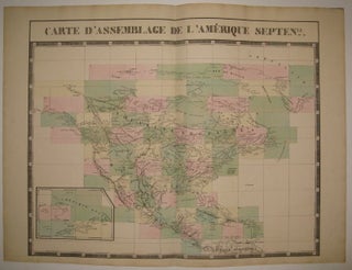
Brussels: Vandermaelen, Phillipe Marie, 1827. Map. Large format lithograph with original hand color wash. Image and title measures 19 3/8" x 24 1/8". Beautiful double page map of North America. Shows states, towns, waterways and topographical and geographical features. Includes an inset of northeastern North America. From Vandermaelen's 6 volume "Atlas universel de geographie physique, politique, statistique et mineralogique, sur l'echelle de 1/16411836" in which each map can be combined as gores to form an immense globe. The atlas was..... More
.jpg?width=320&height=427&fit=bounds&auto=webp&v=1567530049)
Paris: J. Hetzel. Frontispiece and numerous black & white woodcuts throughout the text by J. Ferat & engraved by Ch. Barbant, some plates delicately colored. 368pp. Short 4to, bound in 1/2 crimson morocco, red cloth, ornately gilt spine a.e.g. Paris: j. Hetzel, no date, ca. 1910. Very good (+). A very good copy. Les Voyages Extraordinaires. More
8vo, cloth, d.w.; (marginalia). Harvard UP, 1963. More
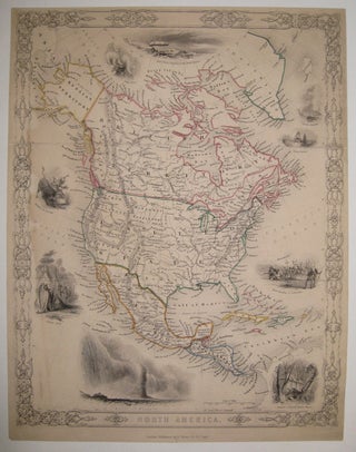
London: G. Virtue. Map. Engraving with original hand outline. Image measures 12.5" x 9.75". Rare map of North America, circa 1855. After Tallis, this detailed map shows Greenland, Canada, Alaska (Russian territory), the United States, Mexico and Central America. The vignettes are characteristic of Tallis, but different subject matter from his own "North America" map: "Geysers, Iceland", "Whale Fishery", "First landing of Columbus", "Remains of Ancient Temple, Mexico", "Falls of Niagara", "Indian Chief", "Hunting the Buffalo", "White Bears" and "Captn..... More
Hello from Denmark, Just wanted to say that I received the book today (the fastest delivery from the US I have ever encountered) and what a lovely book too...
Dear Argosy Books, This is just to let you know that the D.H.Lawrence Manuscript arrived safe and sound yesterday via DHL, and in record time! I'm very pleased with it. Many thanks for taking the time and trouble to make sure the item was well protected and packed before you sent it. As a result, it arrived in pristine condition and I am very grateful to you for ensuring no damage would occur to it during transit. With all good wishes