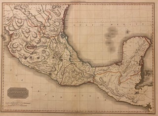
Spanish Dominions In North America Middle Part
London: Caldell & Davies, 1815. Map. Engraving with hand coloring. Image measures 20" x 27.75". This large map depicts the southern part of Mexico with the Yucatan Peninsula, as well as parts of Guatemala and modern-day Belize. Its most remarkable feature is its topographical detail, which is among the best recorded in a British atlas. The map provides an informative view of the country's major watersheds and volcanoes with fine engraving. It was published in Pinkerton' "Modern Atlas" and is..... More