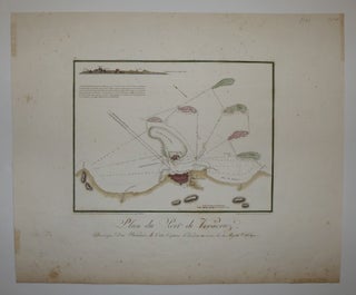
Plan du Port de Veracruz
1807. Engraving with original hand coloring. Image measures 10 x 11". Sheet measures 15.5 x 18.75". This map is an early nautical rendering of the harbor of Veracruz, Mexico, oriented with north to the upper left. It focuses on shoreline geography and depths, particularly around the various islands and sand bars off the coast. In the upper left corner of the map is a profile view of the region's mountains. Below is a French description of the harbor attributed to..... More