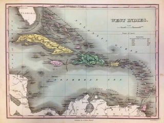
West Indies
Philadelphia: Anthony Finley, 1824. Map. Engraving with original hand coloring. Image measures 8.5" x 11.25". This lovely 1824 map by Anthony Finley features the West Indies and Caribbean Islands. Extends from southern Florida to northern South America and includes the Bahamas, the Leeward and Windward Islands. Cat Isle in the Bahamas is noted as 'the first land seen by Columbus, 1492'. The map is beautifully detailed and notes the important cities and some topographic features. The map is in good..... More