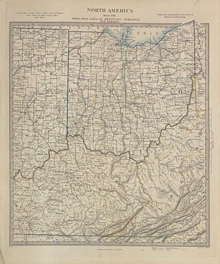
North America Sheet VIII Ohio, with Parts of Kentucky, Virginia, and Indiana
London: George Cox, 1855. Map. Steel engraving with original hand outline. Image measures 15" x 12 1/2" Greatly detailed map of Ohio with parts of Kentucky, Virginia, and Indiana, divided into counties. Shows towns, major routes, waterways and railroads. In very good condition with a slight crease to upper left corner. The Society for the Diffusion of Useful Knowledge was formed in 1826 and published low cost maps with the goal of reaching a large market, while still maintaining high..... More