
Chicago; The History of Its Reputation.
508pp. 8vo, cloth. N.Y.: Harcourt, (1929). vg. More
508pp. 8vo, cloth. N.Y.: Harcourt, (1929). vg. More
Chicago: Contemporary Books, 1979. Almost 250 Illus. 4to, gray cloth, d.w. Chicago: Contemporary Books, 1979. Very good(+). More
New York: Dover, 1979. Illus. 87pp. 4to, pr. wrs. New York: Dover Publications, (1979). Very good Presentation copy from David Lowe. More
New York: Watson-Guptill, 2000. Over 200 Illustrations. 261 pages, 4to, printed wrappers. New York: Watson-Guptill, (2000). Near Fine Presentation copy. More
New York: Houghton Mifflin, 1978. Over 200 Illus. 4to, pr. wrs. Boston Houghton Mifflin, 1978. Very good Presentation copy from the author to Francis Steegmuller. More
illus. 8vo, cloth, d.w. Englewood Cliffs: Prentice-Hall, (1960). vg. More
Urbana: University of Illinois Press, 1974. Illustrated in color and black & white. 297 pages. Oblong 4to, blue and white cloth, dust wrapper; wrapper with a few very small tears at edges. Urbana: University of Illinois Press, (1974). First edition. A near fine copy in a very good(+) wrapper. More
New York: Harper, 1952. 8vo, cloth-backed boards. New York: Harper & Brothers, (1952). More
New York: Doubleday, 1976. Illustrated. 828 pages. Thick 8vo, blue cloth, chipped d.w. New York: Doubleday, 1976. Very good(+) in very good(-) dust wrapper. More
Chicago: University of Chicago Press, 1969. Many Illus. 510pp. Square 4to, pr. wrs. Chicago: University of Chicago Press, (1970). Near Fine. More
facs. 112pp. 8vo, cloth. Chicago: Wright Howes, 1944. First Edition. Very good. One of 200 copies. More
Chicago: Privately Printed, 1931. Facsimiles. 14 pages, thin 8vo, stiff printed wrapper; covers dusty. Chicago: Privately Printed, 1931. Internally fine, a very good copy. One of 250 copies. More
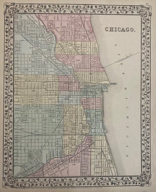
Washington: Samuel Augustus Mitchell Jr., 1871. Map. Lithograph with original hand coloring. Image measures 13.50" x 11.50" This lovely map of Chicago from the 1871 edition of Mitchell's New General Atlas shows the City of Chicago as well as some parts of the surrounding suburbs. Streets are labeled, as well as parks, railroad lines, waterways, and some institutions. Wards are numbered as well. A fine map. Samuel Augustus Mitchell Sr. (1792-1868) was one of the leaders in American cartography of..... More
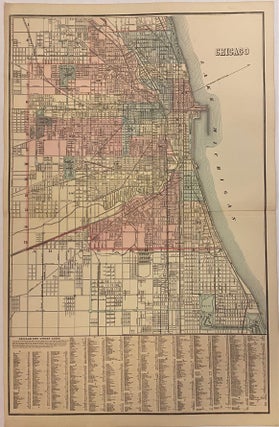
Washington: Samuel Augustus Mitchell Jr., 1881. Map. Lithograph with original hand coloring. Image measures 22 1/4" x 14 1/2" This lovely map of Chicago from the 1881 edition of Mitchell's New General Atlas shows the City of Chicago as well as some parts of the surrounding suburbs. Streets are labeled, as well as parks, railroad lines, waterways, and some institutions. Wards are numbered as well. An index in the lower part of the map provides an alphabetized street guide. Samuel..... More
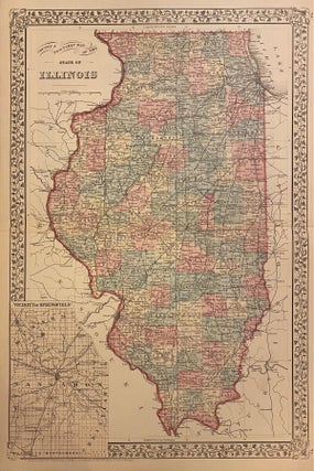
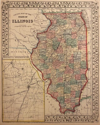
Philadelphia: Mitchell, Samuel Augustus Jr., 1882. Map. Engraving with original hand coloring. Image measures 21 1/4" x 14 1/8" Beautiful double-page map of Illinois divided into counties. Showing townships, towns, major routes, waterways and railroads. Features an inset of the vicinity of Springfield, the state's capital. Plan of Cincinnati on verso. In excellent condition. Original centerfold as issued. Samuel Augustus Mitchell Sr. (1792-1868) was one of the leaders in American cartography of the 19th century and pioneered the conversion of..... More
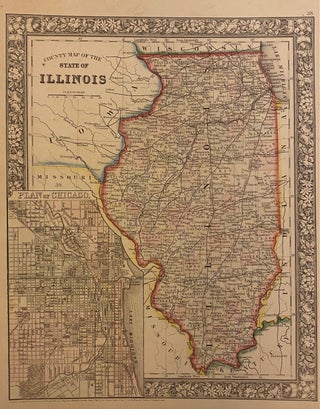
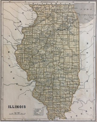
Philadelphia: Mitchell, Samuel Augustus Jr., 1866. Map. Engraving with original hand coloring. Image measures 13.5" x 10.75". Great map of Illinois divided into counties showing towns, major routes, railroads and waterways. Includes a detailed town plan inset Chicago. Samuel Augustus Mitchell Sr. (1792-1868) was one of the leaders in American cartography of the 19th century and pioneered the conversion of engraved map plates to more affordable lithographic plates. His son, Samuel Augustus Mitchell Jr. continued his father's successful mapmaking and..... More
Philadelphia: Mitchell, Samuel Augustus Jr., 1869. Map. Engraving with original hand coloring. Image measures 13 3/4" x 11" Great map of Illinois divided into counties showing towns, major routes, railroads and waterways. This 1869 edition features an inset of the Vicinity of Springfield, the state's capital. Springfield rose to importance during the Civil War, serving as a training camp for Union soldiers and later as a camp for Confederate prisoners of war. After the war ended in 1865, the city..... More
New York: Smithsonian, 2008. 8vo, gray cloth, d.w. (New York): Smithsonian Books, (2008). Very good. More
New York: Harper & Brothers, 1844. Map. Color lithograph. Image measures 14" x 11". This early graphic map of Illinois from 1844 shows much detail within the state borders, and labels Iowa, Missouri, Kentucky, and Indiana bordering it, as well as Lake Michigan. The counties are drawn and labeled and the state capital, county towns, canals, railroads, and common roads are labeled. Sidney Edwards Morse (1794-1871) was an American geographer, journalist, and inventor. He shared his innovative spirit with his..... More
New York: Harper, 1967. Frontis. 8vo, original green cloth, d.w. slightly chipped, ex-lib, front flyleaf browned. New York: Harper & Row, (1967). More
New York: Scribner, 1950. Illus. 2 vols. 8vo, red cloth, boxed, box rubbed, small tear to head of spine of volume 2. New York: Scribner's, 1950. More
Norwalk: Easton, 1988. Illus. 2 vols. 8vo, full blue leather. Norwalk: Easton Press, (1988). Fine. More
New York: Schuman, 1946. A few illus. 8vo, reddish cloth, pictorial d.w. New York: Schuman, 1946. Very good. More
Chicago: University of Chicago Press, 2004. 540pp. 8vo, pr. wrs. Chicago: University of Chicago Press, (2004). Fine. More
Frontis. 662pp. 8vo, cloth, d.w. Southern IL UP, n.d., (ca. 1957). vg. More
Hello. I think that you will like to know that the Robert Frank's book came today in perfect conditions. You get my congratulations for so fast shipping. Best regards.
A fine website and a distinguished store. It's been a pleasure doing business with Argosy in the past and I look forward to more transactions in the future.