
General Cartography
New York: McGraw-Hill, 1938. Illustrated in black and white. x, 370 pages. 8vo, black decorative cloth (minor wear at head/tail). New York: McGraw-Hill, 1938. Very good(+). From the McGraw-Hill Series in Geography. More
New York: McGraw-Hill, 1938. Illustrated in black and white. x, 370 pages. 8vo, black decorative cloth (minor wear at head/tail). New York: McGraw-Hill, 1938. Very good(+). From the McGraw-Hill Series in Geography. More
8vo, cloth, d.w. London: Routledge and Kegan, (1960). vg. More
New York: Dodd, Mead & Co., 1939. Colored frontispiece by Gordon Grant, many illustrations and charts. 452pp. 4to, blue buckram. New York: Dodd Mead & Co., 1939. Very good. More
New York: Norton, 2007. Color and black & white illustrations. 455 pages. 8vo, two-toned boards, d.w. New York: Norton, (2007). Fine. More
Paris: Delamarche, 1784. Illustrated with 52 fine double page copper plate maps with original hand outline color, plus a plate numbered 47(2). 7 pp. including table of contents. Beautifully engraved title page, has paper label torn off, and a stamp underneath. 4to (11.5" x 9.75"), minor scuffing to original marble board binding, with gilt and leather spine in 7 compartments. Many maps have paper and glue residue in margin (from early tab inserts?). Paris: 1784. Fine atlas including four world..... More
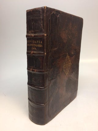
Venice: Giordano Ziletti, 1564. 3 parts in 1. Each part has a separate title page with large printer's device. Part 2: Espositioni et Introduttioni Universali di Girolamo Ruscelli, sopra tutta la Geografia di Tolomeo. Part 3: Discorso Universale di M. Gioseppe Moleto mathematico. Illustrated with 63 (of 64) fine double-leaf copper engraved maps, including the rare "World in Hemispheres". Additional large in-text engravings and decorative initials throughout. [8], 358, [110], [204], [48] index, 47 pages. Short thick 4to, bound in..... More
Exton: Schiffer Limited, 1977. Profusely illustrated in black and white, plus a fold-out section with actual wood samples. 202 pages, 8vo, wood-patterned boards with a gilt-lettered spine, dust wrapper. Exton, Pennsylvania: Schiffer Limited, (1977). A fine copy in a near fine dust wrapper. More
New York: McGraw-Hill, 1980. Illustrated throughout in color by Chen Fuli. 284pp. Wide 4to, red cloth, slightly rubbed d.w. New York: McGraw-Hill, (1980). Slightly sunned edges, still a near fine copy in a near fine dust wrapper. A book by Jugoslovenska Revija and the Shanghai People's Art Publishing House. More
Many Illus. London, (1961). More
New York: Arco, 1970. Illus., folding map of London. 8vo, black cloth, d.w. New York: Arco, (1970). Near Fine. More
Amsterdam: Meridian, 1962. 159 pages + 16 folding maps in pocket at rear. Slim 8vo, printed gray wrappers. Amsterdam: Meridian, 1962 First Edition. A very good(+) copy. More
London: Oxford, 1964. 103pp., slim 8vo, green cloth, d.w. London: Oxford UP, 1964. Near Fine. University of London Heath Clark Lectures. More
New York: Oxford University Press, 1970. 550 pages. Thick 8vo, blue boards, dust wrapper, sunned on spine, price clipped. New York: Oxford University Press, (1970). A near fine copy in a very good dust wrapper. More
illus. thin 8vo, cloth; (cloth soiled). London: Batsford, (1949). More
108pp. + 8pp. of ads. 16mo, leather backed bds., (rubbed, foxed). Philadelphia: By the author, 1829. First edition. "Editions of his Map of the United States were issued to be sold separately." Howes T-28. "The list of maps advertised as for sale in the 8pp. at the end is useful." Streeter Sale VI, 3834. Graff 4062. More
1943. Endpaper map. 454pp. blue cloth, worn d.w. London: Methuen, (1943). Second printing. Methuen's Advanced Geographies. More
Montpelier: E. P. Walton and the Author, 1824. of All the Counties, Towns, Rivers, &c. Folding map of Vermont. 3 engraved plates. 312pp. 12mo, contemporary calf, leather label, edges of corners worn and bumped, calf rubbed, several pages dampstained in margins, including title-page, scattered light foxing including the map and plates. Montpelier: E. P. Walton and the Author, 1824. First Edition Unsigned presentation copy from the author. Zadock Thompson was a Vermont historian and teacher at the University of Vermont..... More
Montpelier: E. P. Walton and the Author, 1824. of All the Counties, Towns, Rivers, &c. Folding map of Vermont. 3 engraved plates. 312pp. 12mo, contemporary mottled calf, leather label, corners bumped, small amount of light foxing to map, calf rubbed, many pages with light foxing including two of the plates. Montpelier: E. P. Walton and the Author, 1824. First Edition Zadock Thompson was a Vermont historian and teacher at the University of Vermont and other schools. Howes T-207. Sabin 95546..... More
New York: Thomas Crowell, 1976. 350 illus. and 14 fold-out maps, 10 in full color. folio, brown cloth boards (beautiful embossed compass rose emblem), d.w., brand new. N.Y., 1976. In excellent condition. An illustrated survey of 2,000 years of maps and mapmakers. First American edition. More
Hertfordshire: dorset press, 1981. 350 illus. and 14 fold-out maps, 10 in full color. folio, brown cloth boards, d.w.(price tag sticker on cover).N.Y., 1976. An illustrated survey of 2,000 years of maps and mapmakers. slightly smaller than original edition still a beautiful copy. More
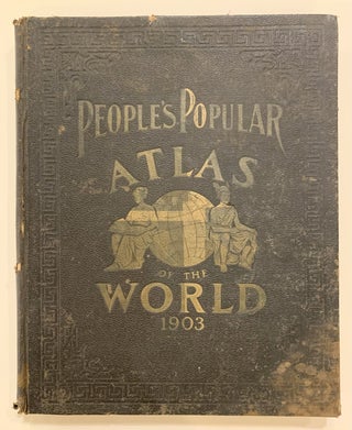
Chicago: Thompson and Thomas, 1903. Folio atlas, 320pp. Black cloth, with title on repaired spine, stains to cover corners bumped and gilt title faded, some foxing and toning but otherwise in good condition. Chicago: Thompson and Thomas 1903. Modern geography maps, with the world and its various political divisions. Illustrated by numerous views and charts; supplemented with statistics, diagrams and informational charts. Beautifully printed in color with a playful publishing symbol on most maps. Index included. More
Madrid: Cosano, 1932. With a biography of the author and translation from Latin by Dr. Jose Goyanes Capdepvila. 379pp., short 8vo, printed flexible boards; pages toned, brittle, ownership signature front free endpaper, frayed at head of spine, covers dust soiled. Madrid: J. Cosano, 1932. A very good copy. Biblioteca Clasica de la Medicina Espanola Volume X. More
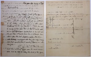
Washington: 1815. 3 pages (front and back), 9.75 x 7.75 inches, Washington, January 12, 1815, to Jedediah Morse, the father of American geography, explaining that he has taken to secure from a Mr. Mallory, the owner of a book store in Georgetown, a deposition which Morse needs for a pending lawsuit in Boston. Ward also comments on the affairs of Congress: "Since some time in November we have been constantly engaged upon the several revenue bills for filling the ranks..... More
New York: E.P, Dutton & Co., 1965. 350pp. Illustrated endpapers, black and white photos. 8vo, tan cloth with decorative stamping of a palm tree, New York: Dutton, 1965. A very good(+) copy. More
Berne: Kummerly & Frey, 1967. Text in French. Translated from the German by Daisy Wepf-Voumard and Jean-Pierre Porret. Color and black & white photographic illustrations, several maps. 104 pages. Small 4to, glossy pictorial boards. Berne: Kummerly & Frey Editions Geographiques, (1967). First French edition. A near fine copy. More
I'd like to say thank you very much for this wonderful book! The parcel arrived yesterday in best condition. Thank you also for the very professional processing, especially the customs formalities. I've already browsed through it briefly: a very interesting work in its original, very well preserved condition. Simply wonderful!
I write to you these few words to tanks for your friendly service and to notify the correct arrive in Rome of my two maps (New York and Paris). Tank you and good bye to my next visit in NY.