
The Niger Explored.
London: Oxford University Press, 1968. 263pp. 8vo, cloth, d.w. London: Oxford UP, 1968. very good. More
London: Oxford University Press, 1968. 263pp. 8vo, cloth, d.w. London: Oxford UP, 1968. very good. More
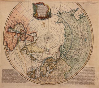
London: Bowen, Emanuel, 1764. Map. Hand colored engraving. Image measures 14 9/16" x 17 5/16". Scarce antique map of the North Pole printed in 1764. Centered on the article circle, the projection extends to the 50th degree of latitude, showing the Eastern half of Canada, Northern Europe, parts of Russia, and Siberia. Surrounding text Overall foxing and toning, minor wear and chipping to edges with repair into lower right text, otherwise in good condition. Explorer routes rendered and mention that..... More
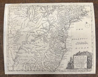
London: Gentleman's Magazine, 1754. Map. Engraving. Measures 8 3/4 x 11 inches. Fascinating map of English and French forts in the Colonies during the French Indian war. Many Indigenous names are included. Strange boundaries extend west and north in the colonies, revealing the disputes over land with the French. Strange cartouche with a mans head in a bush with an arrow in it. Mounted on linen and margins cropped but otherwise in good condition. The Gentleman's Magazine, founded by Edward..... More
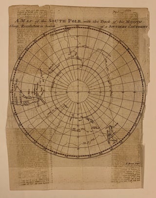
London: Gentleman's Magazine, 1755. Map. Engraving. Measures 8 5/8 x 8 3/8 inches. Fascinating map of the Southern Hemisphere, published in Gentlemen's Magazine in 17776. The chart traces Cook's search for the southern continent, circling but not reaching Antarctica, with the southern portion of South American, the Cape of Good Hope, and New Zealand shown. Dampstains and margins cropped with repairs to right margin. The Gentleman's Magazine, founded by Edward Cave of London in 1731, was the first to use..... More
New York: St. Martin's, 2004. Illustrated in black and white throughout. 254 pages. 8vo, black boards, dust wrapper. New York: St. Martin's, (2004). A very good(+) copy, clean except for jottings on back free end paper, in a poor dust wrapper, water damage along bottom edge and back cover. A rare mix of compelling history and classic adventure story. Brimming with tales of ships, sailors, and baffling bureaucracy. More
London: Edward Arnold, 1927. Frontispiece. 17 black and white photo illustrations, 296pp., 8vo, original burgundy cloth. London: Edward Arnold & Co., 1927. Second Impression. Very good (+). This work is largely taken from the author's diaries and notes compiled while observing wild animals as a Forest Service worker in India. More
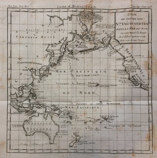
Louis Brion de la Tour. Map. Engraving. Image measures 9 x 9 inches. Page measures 11.5 x 10 inches. Small chart showing the third and final voyage of Captain James Cook through the Pacific. It covers the North American coastline from Mexico through Alaska, the Asian coastline through Cambodia and down to New Zealand. Unusual depiction of icebergs. Foxing throughout. Louis Brion de la Tour (1756-1823) is best known for his 'Atlas General' published in collaboration with Louis Charles Desnos..... More
London: Cassell. Hundreds of black & white illustrations throughout the text. 4 volumes bound in 2. Tall thick 8vos, bound in older 3/4 black calf with red leather spine labels; bindings worn but sound. London: Cassell, (no date, circa 1892). A very good copy. More
New York: Abrams, 1994. Profusely illustrated in color & b/w, 484pp., folio, brown cloth. (New York): Harry N. Abrams, (1994). Reprint. Near Fine. More
London: James Bohn, 1834. Illustrated with 11 lithographed plates and folding map at rear. 2 volumes in one. viii, 472, xxxiv, (2), (2), 238 pages. Thick 8vo, handsomely bound in full contemporary brown calf with ornately gilt borders on covers and spine; marbled endpapers and pages edges. London: James Bohn, 1834. First edition. Ex-library copy with small blue stamps from"Relations Department" on halftitle, title and back of map; removed pocket at rear and inked numerals on spine. Light scattered toning..... More
New York: Putnam, 1927. With 54 illustrations. 221 pages. Thick 8vo, gilt-lettered red cloth (spine quite faded and ends worn; inner hinge a bit loose). New York: G.P. Putnam's Sons, 1927. First edition. Overall a good copy of this scarce book, internally clean. More
New York: Putnam, 1929. With 60 illustrations and a map. xv, 281 pages. Thick 8vo, gilt-lettered red cloth (spine lightly sunned and a touch worn at ends). New York: G.P. Putnam's, 1929. Second impression. Lacking the front free endpaper and paper hinge re-glued, else a very good(+) solid copy. "Approved by the Boone & Crockett Club" More
New York: Allerton, 1922. Folding map. xxii + 360 pages, 12mo, brown cloth; personal bookplate inside front cover. New York: Allerton Book Co., 1922. A very good(+) copy. More
Boston: 1933. 1 page, 10.75 x 8.25 inches, Boston, September 23, 1933. In this letter, Byrd solicits funds from a New York firm for his upcoming South Pole expedition, in part: "...You helped make my last expedition possible...In that connection, thanks to our geographers, some superb maps of hitherto unknown areas have been made. Five scientific books are in the process of completion, covering Geology, Geography, Glaciology, Oceanography, Meteorology, Magnetism, Biology and Radio...Would you this time be willing to supply..... More
Lincoln: University of Nebraska Press, 2003. Illustrated with a handful of b/w images. 204 pages. Thin 4to, black cloth. Lincoln: University of Nebraska Press, (2003). A very good internally clean copy with considerable sunning to to spine and front cloth; lacking dust wrapper. More
New York: Dutton, 1980. Illustrated abundantly in black and white with some in color. 288 pages. Small 4to, blue cloth with silver spine lettering, d.w. (lightly edgeworn & sunned). New York: E.P. Dutton, (1980). First American edition. Very good(+) in a very good(+) dust wrapper. Forewords by John Hunt and David Attenborough. More
London: George Philip & Son, 1885. Numerous black & white illustrations, many with tissue guards, some folding and a large folding map in rear pocket. 569pp. Thick 8vo, blue cloth, decoratively gilt spine (hinges strengthened and top & bottom of spine worn). London: George Philip & Son, 1885. A new edition, with new and original matter and corrected map. A very good copy, internally near fine. Previous owner's bookplate. More
New York: 1930. 8vo, cloth; covers worn. New York, 1930. A very good copy. More
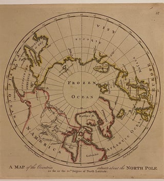
Philadelphia: M. Carey, 1814. Map. Engraving with hand coloring. Image measures 10" x 10", sheet measures 10 3/8" x 17" This 1814 map of the North Pole is centered on the Arctic Circle, labeled as "Frozen Ocean", and oriented along the meridian of Philadelphia, where this map was published. The northern coast of Eurasia is carefully delineated, while the northern edge of North America is less clear. Notations in the northwest indicate the sea extending to the 70th degree of..... More
New York: Pocket, 2000. Photographs by Russell Kaye. 147 pages, 4to, cloth-backed boards, d.w. New York: Pocket Books, (2000). A very good copy in a very good dust wrapper. More
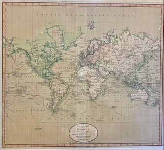
1801. Map. Engraving with original color wash. Frame dimensions 24 1/8 x 26 1/2 inches. Beautiful map of the world presented with a Mercator projection which celebrates 18th c exploration. Notations throughout the map on the discoveries of Cook, Vancouver, and Perouse. John Cary (1754-1835) was a British cartographer and engraver. His highly detailed and accurate maps mark a turning point from the earlier emphasis on decoration toward a greater emphasis on information. This map is a fine example of..... More
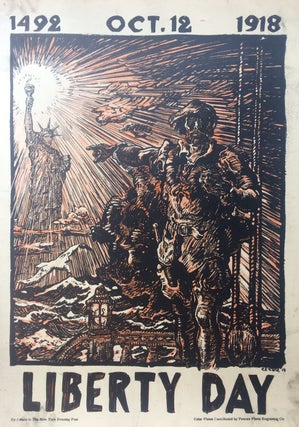
New York: New York Evening Post, 1918. Lithograph. 25" x 18". Some staining and fingerprints at margins. In very good condition. Unusual inky printers proof of this dynamic design which shows Christopher Columbus on deck of a ship pointing towards a radiant Statue of Liberty. On October 12, Columbus made landfall on one of the Bahamian Islands. Oscar Edward Cesare (October 7, 1883- July 25, 1948) was a Swedish born painter and illustrator based in Chicago. More
New York: Hill and Wang, 2002. Lightly illustrated in b/w. 559 pages. 8vo, charcoal boards, d.w. New York: Hill and Wang, (2002). First edition. A very good(+) copy--slight staining to top edge, scuffing near head of boards; in a very good(+) wrapper, edges lightly scuffed, sticker residue on rear panel. More
illus. 437pp. 8vo, cloth, d.w. Indianapolis: Bobbs-Merrill, (1967). vg. More
Boston: Houghton Mifflin, 1998. Illustrated in black and white. viii, 342 pages. 8vo, brown cloth-backed boards, d.w. (spine sunned). Boston: Houghton Mifflin, 1998. Light wear at tail, some neat pencil marginalia. A very good(+) copy in a near fine dust wrapper. More
Thanks for sending the book quickly. I wish every book seller would take the care that you did to make sure the book got to the receiver in the best possible condition!
I am very pleased that you took the time to consult me on the price before just adding the additional shipping cost onto my credit card. Ordering things on-line, one runs into all kinds of less-than-considerate business practices... Thanks again for taking the time to contact me. I'm looking forward to the book.