
Land of the Long Day
New York: Henry Holt, 1956. Illus. 8vo, black cloth, d.w. torn and chipped, spine ends of cloth worn, cloth soiled. New York: Henry Holt, (1956). More
New York: Henry Holt, 1956. Illus. 8vo, black cloth, d.w. torn and chipped, spine ends of cloth worn, cloth soiled. New York: Henry Holt, (1956). More
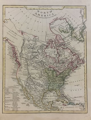
London: Robert Wilkinson. Map. Engraving with hand coloring. 13.5" x 10.75". Small tear at bottom right edge, image unaffected. In very good condition. A detailed map of North America containing a large amount of information. The key shows Louisiana as part of the United States, along with 13 United States, 1 Allied State, and 6 Subject States. The key also shows British Possessions as Canada and New Britain; Spanish Dominions as Mexico, New Navarre, and Florida; and Danish Settlements as..... More
Toronto: Macmillan, 1960. Frontis portrait. 183 pages. 8vo, red cloth, d.w. Toronto: Macmillan, 1960. A very good copy--light staining to top outer edge, some fading to cloth edges; in a good dust wrapper, sunned and tattered. More
Frontis. 2 vols. thick 8vo, cloth. Boston: Houghton Mifflin, 1915. First Edition. very good Lord Strathcona spent many years in Labrador and was a member of the Canadian Parliament in 1870. More
thick 8vo, cloth; (corners slightly bumped, otherwise very good). Belleville: Mika Publishing, 1975. More
Toronto: Key Porter Books, 1985. Illustrated in color and in black and white. 200 pages. Large 4to, burgundy cloth with gold lettering, d.w. (price-clipped, lightly edgeworn). Toronto: Key Porter Books, (1985). Near fine in a very good(+) dust wrapper. Tipped in letter at front free endpaper to participants in VIA Rail Canada's "Rendez-vous Canada 1989". Foreword by Don Ball Jr. More
Cambridge: Cambridge University Press, 1990. Many black & white illustrations. 4to, red cloth, d.w. Cambridge: University of Cambridge Press, (1990). First Edition. Small private library ink numbers on cloth & wrapper spine, otherwise a fine copy. More
Cambridge: Harvard University Press, 1979. Many Illus., some in color. 4to, black cloth, edges of corners lightly worn. Cambridge: Harvard University Press, 1979. More
illus. 8vo, cloth. Toronto: Dent, (1940). vg. More
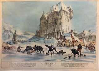
Montreal: 1957. Print 1957 commemorative image. Page size 16.5" x 23" Initialed in the lower right corner of print. Signed by artist just below lower right corner of print. Caption lower margin: "The earliest representation of Curling is in a painting by PIETER BRUEGAL around 1550. The Royal Montreal Curling Club dates from 1807 and celebrated its 150th anniversary by a BONSPIEL in 1957. The Grand Caledonian Curling Club was founded in Edinburgh in 1838./ The Oldest Club in United..... More
London: Van Nostrand, 1989. Illustrated with black and white photographs. 200 pages, small slim 4to, blue cloth (front board slightly warped), dust wrapper. London: Van Nostrand, (1989). A very good(+) copy in a very good(+) dust wrapper. Presentation copy, signed by the author on front free endpaper. More
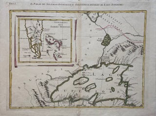
Venice: Antonio Zatta, 1778. Map. Engraving with original hand coloring. Measures 16 3/4" x 13 1/4". Some worm holes to center fold and toning but otherwise in good condition. This unusual map depicting Lake Superior and southern Florida appeared in the two-volume Italian edition of Raynal's "Storia dell' America Settentrionale", published in 1778. The map primarily features Lake Superior, and refers to the native inhabitants of the region, including the Kilistinesi (known as Cree), in both the title and throughout..... More
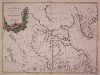
Venice: Antonio Zatta, 1778. Map. Engraving with original hand coloring. Image measures 11.75" x 16". Beautiful map of Canada centered on Hudson's Bay and Labrador. Indigenous names are noted and Greenland is shown. Some discoloration along edges and centerfold at margins. Antonio Zatta (1775-1797) was the most prominent Italian map publisher of the late 18th century. His Venice-based publishing company produced maps that mark an important transition from 18th- to 19th-century cartographic styles. He updates and redefines the traditional title..... More
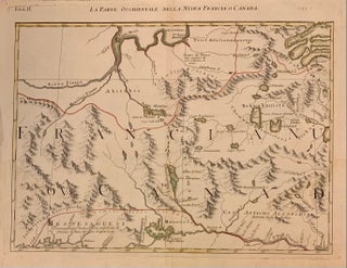
Venice: Antonio Zatta, 1788. Map. Engraving with original hand coloring. Image measures 12.25" x 16.75". Beautiful early map of part of Ontario and Quebec including the Ottawa River and lower Hudson's Bay. Montreal is noted lower right and indigenous names are noted. Part of a twelve section map comprising the Italian edition of Mitchell's map of North America. Light stains lower right but otherwise in good condition. Antonio Zatta (1775-1797) was the most prominent Italian map publisher of the late..... More
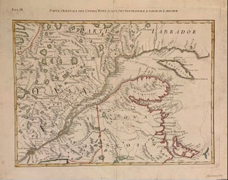
Venice: Antonio Zatta, 1788. Map. Engraving with original hand coloring. Image measures 12.25" x 16.75". Beautiful early map of part of Southeastern Canada including Quebec, the Saint Lawrence, and Prince Edward Island. Part of a twelve section map comprising the Italian edition of Mitchell's map of North America In good condition with some light stains to the margins and surface abrasions. Antonio Zatta (1775-1797) was the most prominent Italian map publisher of the late 18th century. His Venice-based publishing company..... More
Just wanted to say thank you for a great book. It was in great condition (exactly as described) & was packaged well... Keep up the good work and we continue to buy online!
Dear Sirs, Just to let you know, I've received my order -- it's a beautiful copy -- thank you again for your attention.