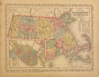
Map of Massachusetts and Rhode Island
Philadelphia: Desilver, Charles, 1856. Map. Engraving with original hand coloring. Image measures 11 3/4" x 15 1/4" Classic map of Massachusetts and Rhode Island divided into counties. Shows towns, major routes, railroads, waterways, and topographical features. An inset in the lower left features a plan of Boston, with streets, bridges, railroads, and major landmarks labeled. A statistical table in the upper right lists populations by county. In very good condition, with some toning to the left margin, and minor chips..... More


.jpg?width=320&height=427&fit=bounds&auto=webp&v=1567530049)