
The Boston Money Tree.
8vo, cloth, d.w. N.Y.: Thomas Crowell, (1977). vg. More
8vo, cloth, d.w. N.Y.: Thomas Crowell, (1977). vg. More
New York: Pantheon, 1999. Illus. 694pp. 8vo, 1/2 black cloth, boards lightly soiled, first 16 pages wavy on bottom margins. New York: Pantheon Books, (1999). More
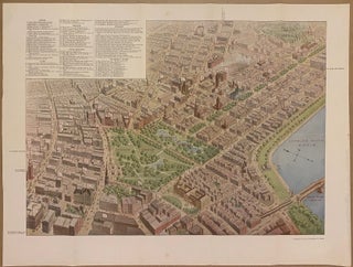
American Bankers Association, 1913. Map. Full color offset lithograph. Image measures 13 1/4" x 18 1/2" This pictorial map of Boston was published in 1913 for the 39th annual convention of the American Bankers Association. Centered on the area between Copley Square and Boston Common, the map is oriented toward the southwest, extending to Fenway park in the upper right to the old City Hall in the lower left. Major points of interests are numbered, corresponding to an index in..... More
Boston: Redding, 1844. Being a Series of Sketches Illustrative of Whims and Women in the 'Athens of America'. Hand-colored frontispiece, 2 additional colored plates. 56pp., short thin 4to, original dark brown moire silk (rebacked in plain brown cloth; scattered foxing). Boston: Redding and Company, 1844. Very scarce. Contains chapters on Sewing Circles, Popular Lectures, and Fancy Fairs. More
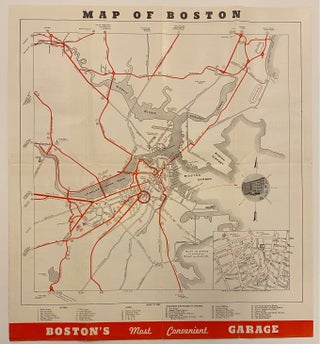
Boston: New England Folder Distributing Co., 1939. Map. Measures 17" x 15 1/2" This map of Boston published in 1939 highlights major routes to central Boston in red. An inset in the lower right corner shows the area around Eliot St. Garage, just south of Boston Common. Colleges and universities are depicted pictorially, including Harvard, M.I.T., and Simmons College. An index in the lower margin lists hotels, clubs, and other major buildings and places of interest. In very good condition..... More
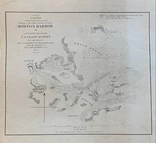
Washington: Government Printing Office, 1851. Sea chart. Uncolored engraving. Image measures 7.5 x 9 inches. This fantastically detailed sea chart issued by the United States Coast Survey in 1851 beautifully depicts the Boston Harbor and tidal currents. It extends as far north as Nahant, as far south as Petticks Island, to Hull, and as far west as Boston.The map is in good condition, with minor toning. Alexander Dallas Bache (1806-1867) was an incredibly prolific surveyor, who worked as the superintendent..... More
Port Chester: Robert A. Bang, 2004. With b/w photos throughout. 177 pages. Slim 4to, glossy pictorial boards. (Port Chester): Robert A. Bang, (2004). A fine copy. More
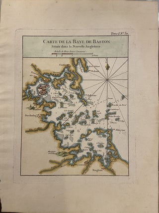
Paris: Jacques Nicolas Bellin, 1764. Map. Engraving with hand coloring. Page measures 12 1/2" x 9 3/8". Image measures 9"x 7". Charming early chart of Boston Harbor. Shows depths and sandbars. Very good condition. Jacques Nicolas Bellin (1703-1772), was the official hydrographer to the French king and the first person to hold the title of "Ingénieur de la Marine of the Depot des cartes et plans de la Marine" (chief engineer of the French Hydrographical Office). More
many photo. illus., some in color. oblong 4to, cloth, d.w. Boston: Houghton Mifflin, 1975. vg. More
Boston: 1794. from M. Bicker & Sons, wholesalers to Captain William Story. Boston, 1794. Fine with strong folds. "...Having appointed you commander of the Brig Harriot, our orders for you to proceed with the first fair wind to Cowes, England and when arrived to value upon our Mr. Martin Bicker. If he happens to be absent form Cowes, write immediately on to Him at London & ask of him his orders which will attend to in every respect...If it should..... More
Boston: Rockwell and Churchill, 1881. 183pp. 8vo, original brown cloth, spine ends, top of front cover and edges of corners worn, cloth lightly soiled. Boston: Rockwell and Churchill, 1881. Most of the text is an appendix that lists the names of taxpayers in Boston, Brookline, and Chelsea for the years 1674, 1676, 1681, 1685, 1687, 1688, 1691, 1695 with an index of names. More
Boston: State Street Trust Company, 1912. 40 illustrations. Thin 8vo, pictorial wrappers; spine ends worn, faint dampstain in upper gutter, otherwise very good. Boston: State Street Trust Company, (1912). More
Boston: Colonial Society, 1974. More than 170 black & white illlustrations. xv + 316pp., 8vo, blue cloth, d.w.; small inner portion of top and lower edge have minor dampstains, dust wrapper chipped,soiled. Boston: The Colonial Society of Massachusetts, (1974). A very good copy in a very good (-) dust wrapper. More
many color diagrams, some folding. 8vo, cloth; (spine ends repaired). Boston: Rockwell & Churchill, 1893. More
Boston: 1937. Illus. 8vo, tan boards. Boston, (1937). vg Published by the Banks and Trust Companies of Boston. More
Ed. by Milton Halsey Thomas. illus. 97pp. 8vo, cloth, Princeton Univ. Library, 1955. vg. More
Frontis. 757pp. 8vo, buckram; (t.p. and p. 437 have small tears in margin, ex-lib). London, (1861). More
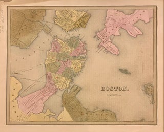
Boston: T.G. Bradford, 1838. Map. Engraving with original hand coloring. Image measures 11 3/8" x 14 1/8". Beautiful early map of Boston and parts of Cambridge, Brookline, Charlestown, East and South Boston. Showing wards, streets parks, railroads and notable landmarks. Light scattered foxing, stain and minor wear to upper right corner, with stains to margins and some offsetting. Thomas Gamaliel Bradford (1802-1887) was a Boston based publisher. He worked as assistant editor of the American Encyclopedia before entering the field..... More
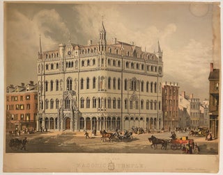
Wiliam D. Stratton, 1865. Original print. Color lithograph. Measures 20" x 25" This rare lithograph of Boston's Masonic Temple, on the corner of Boylston and Tremont Streets, was published in 1865 by William D. Stratton and issued by Buffords' Print Publishing House. The print depicts the proposed masonic temple, designed by artist and architect Merrill G. Wheelock. After Wheelock fell ill, the design was completed by architect George Meacham, and the building was dedicated in 1867. The site continues to..... More
illus. 478pp. 8vo, 1/2 cloth, d.w. New York, (1988). More
New York: McClure Phillips, 1902. Illus. 8vo, blue cloth, corners bumped, spine ends lightly worn, cloth lightly soiled, inner hinges crudely repaired with tape. New York: McClure, Phillips, 1902. More
color illus. 8vo, cloth, d.w. New York: Norton, (1959). vg. More
Boston: 1930. illustrated. Short 4to, 1/2 cloth; edges of boards a bit worn. Boston: Printed for the Society, 1930. Very good. Milestones. More
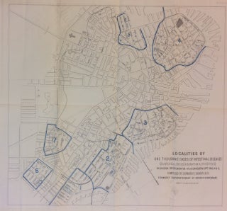
J.H. Bufford's Sons. Map. Lithograph. 17" x 18.25". Shows some light damp staining and foxing. Shows some wear and slight separation along original fold lines, however this results in no image loss. In very good condition. A disease map of mid-19th century Boston, MA showing seven zones wherein cases of intestinal diseases in children had been confirmed. Created by the Boston City Physician's Office to accompany a report from the City Physician on Asiatic Cholera (City of Boston, 1866). Rare..... More
New York: Burt Franklin, 1969. With a brief Description of every Article of Human Food Sold Therein, The Introduction of Cattle in America... Volume I, (all published). 621pp. 8vo, tan cloth. New York: Burt Franklin, (1969). Facsimile of the New York, 1862 edition. More
I usually receive my packages as soon as delivered. However, this one had quite a night outside in a snow storm. Thanks to the extra care in packaging and double layer of wrapping cardboard and plastic bag, the book survived in pristine condition.... It sat in a three foot snow drift pounded by snow plows, in minus 25Temps overnight and was discovered this afternoon, the top of the package peeking out of the drift. If not for the attention to packaging and packing materials, this book would have been destroyed. Please let the people who package our treasures know that they make a difference. Whether in person or mail order, you folks rock. Best wishes from the (damned) frozen Adirondacks...
Dear Argosy, the book was absolutely positively great! Most pleased.