
The Rocks: Sydney.
Drawings by Unk White. 59pp. Slim 8vo, cloth, d.w. Adelaide, 1966. More
Drawings by Unk White. 59pp. Slim 8vo, cloth, d.w. Adelaide, 1966. More
London: George Allen & Unwin, 1953. Illus. 8vo, yellow cloth. London: George Allen & Unwin, (1953). Very good. More
London: Methuen, 1911. Eight illustrations and maps, including two folding. xx + 295pp., 8vo, red cloth, d.w.; dust wrapper worn, chipped at spine ends and corners. London: Methuen & Co., (1911). Second edition. A very good copy in a very good (-) dust wrapper. More
Illustrated. Large 8vo, blue cloth (spine and edges of cover faded). Melbourne University Press, 1936. More
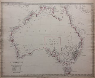
London: Chapman and Hall, 1840. Map. Engraving. Sheet measures 16" x 13.5". Some light foxing and staining. In very good condition. This detailed map by the Society for the Diffusion of Useful Knowledge or SDUK depicts the entire continent of Australia in 1839, including Van Diemen's Land or Tasmania. Incredibly detailed along the coastlines, the interiors are relatively unmapped, reflecting the lack of knowledge of the region. The colony of South Australia, which was established in 1834 is the only..... More
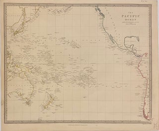
London: Charles Knight & Co., 1846. Map. Engraving. Image measures 12 1/2" x 15 1/2" This highly detailed map by the Society for the Diffusion of Useful Knowledge, or SDUK, depicts the Pacific Ocean. Island groups and coastlines are extensively labeled, while the interiors are relatively unmapped. Some Pacific islands are labeled with question marks, indicating uncertainty of their existence. The map is in excellent condition. The Society for the Diffusion of Useful Knowledge was formed in 1826 and published..... More
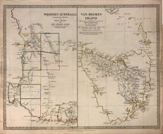
London: Baldwin & Cradock, 1844. Map. Engraving with original hand outline coloring. Sheet measures 13.5" x 16". This lovely 1844 map by the Society for the Diffusion of Useful Knowledge or SDUK depicts Western Australia and Tasmania or Van Diemen's Island. Issued as two separate maps printed on a single sheet, the map of the left details the southwest portions of Western Australia extending from Albany to Jurien Bay. Notes settlements, including those of Swan River and King George's Sound..... More
Illustrated. 220pp. Tall 8vo, cloth, d.w. New York: Taplinger, 1967. More
Melbourne: Oxford University Press, 1962. Tipped-in color frontispiece, 191 illustrations, some in color, 357pp., 8vo, cloth, d.w.; (frontispiece wrinkled, corners bumped). Melbourne: Oxford UP, 1962. Very good (-). More
Illus. in color & b/w. 200pp. 4to, cloth (ends worn). Australia, 1942. A very good(-) copy. More
Illustrated. 8vo, cloth (bookplate; torn dust wrapper). New York, 1946. More
b/w cartoon illustrations. 194pp. Pictorial boards, d.w. New York, (1943). More
Seattle: Decode, 2012. A book of color photographs. Tall 8vo, cloth backed pictorial boards, paper belly band. Seattle: Decode, (2012). Limited first edition. Fine. Signed by both artists on title page. More
Sydney: Angus and Robertson, 1957. 289pp. 8vo, cloth, dust wrapper; d.w. edge-worn & lightly chipped. Sydney, 1957. More
folding chart. 8vo, cloth. N.Y, (1969). More
Edited by Persia Campbell, et al. Maps. illus. Tall 12mo, buckram. Melbourne University Press, 1930. A very good(+) copy in a very good dust wrapper. More
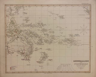
Gotha: Justus Perthes, 1850. Map. Engraving with hand outline coloring. Image measures 12" x 15" Incredibly detailed map in German of the Pacific Ocean, including Australia, Southeast Asia, and New Zealand. Island groups are extensively labeled, and hand coloring is used throughout to indicate colonial holdings. This map appeared in the 1853 issue of Stieler's Hand Atlas. In very good condition with minor spotting, and toning to margins - not affecting the image. The publishing firm of Justus Perthes (1749-1816)..... More
Sydney: Bay Books, 1987. 133 color plates. Small folio, blue cloth. Sydney: Bay Books, (1987). A very good(+) copy. More
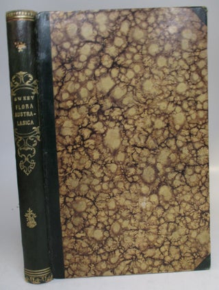
London: James Ridgway, 1827. Illustrated with 56 hand-colored plates. One corner of title page skillfully repaired with no loss of text, alphabetical holograph index bound in. Slim 8vo, 1/2 green morocco, decoratively gilt spine. London: James Ridgway, 1827-1828. A fine clean copy. One the most attractive of Australian botanical books and the first to use live specimens for illustration instead of dried plants or field sketches. Nissen 1924. More
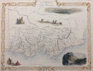
London: Tallis, John, 1851. Map. Steel engraving with original outline hand coloring. Image measures 10.5" x 13.5". Sheet measures 10.5" x 14.5". Shows some light foxing and tape residue from framing. In very good condition. John Tallis Jr. (1817-1876) was a London born bookseller who continued the prolific map publishing company started by his father. After a partnership with his brother, Tallis Jr. expanded the business to New York in 1849 as well as Boston, Cincinnati, Rochester, Philadelphia and Baltimore..... More
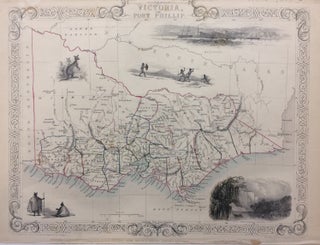
London: Tallis, John, 1851. Map. Steel engraving with hand coloring. Image measures 10.5" x 13.5". Sheet measures 10.5" x 14.5". Some small tears to left edge, image unaffected. Shows some light foxing. In very good condition. Beautiful map of the S central Coast of Victoria centered on Melbourne. John Tallis Jr. (1817-1876) was a London born bookseller who continued the prolific map publishing company started by his father. After a partnership with his brother, Tallis Jr. expanded the business to..... More
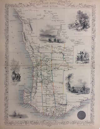
London: Tallis, John, 1851. Map. Steel engraving with hand coloring. Image measures 13.75" x 9.5". Sheet measures 13.75" x 11". Some wear along original fold line, shows some small chips at edges. In very good condition. Early map of Western Australia from Champion Bay to Doubtful Island Bay. The Swan River is a river in the south west of Western Australia. Its Aboriginal Noongar name is the Derbarl Yerrigan. The river runs through the metropolitan area of Perth, Western Australia's..... More
London: Verso, 2003. xviii + 222 pages, 8vo, cloth; dust wrapper; some spotting to outer page edges. London: Verso, (2003). A very good(+) copy in a very good(+) dust wrapper. More
1943. Endpaper map. 454pp. blue cloth, worn d.w. London: Methuen, (1943). Second printing. Methuen's Advanced Geographies. More
Your wonderful antique book Third Year of the War" written by Edward A Pollard and published by Charles B Richardson arrived Today in Australia. I'm very excited to be the new owner of this Historical record of the American Civil War - this wonderful book has found a good home. Kindest Regards
Dear Judith, Vol. 1 received, very pleased with it, particularly as it completes a set which came in with that volume missing!