
The Ocean World of Jacques Cousteau; (Volume 16): The White Caps.
many color illus. 4to, boards, d.w. N.Y.: World, (1974). vg. More
many color illus. 4to, boards, d.w. N.Y.: World, (1974). vg. More
illus. 8vo, cloth. (spine end torn). New York, (1958). Study of the native animals of the Arctic. More
Washington: Government Printing Office, 1876. Edited under the direction of the Hon. G. M. Robeson, Secretary of the Navy. 2 steel engraved frontispieces, 30 wood engraved plates, 6 maps, 2 photolithographs. 696pp. 4to, original red cloth, spine expertly recased with most of original backstrip, edges of corners worn, cloth lightly soiled, light foxing to a Frontis., inner hinges strengthened. Washington: Government Printing Office, 1876. First Edition. Internally a tight, bright copy. The expedition lasted from 1871 to 1873. In 1871..... More
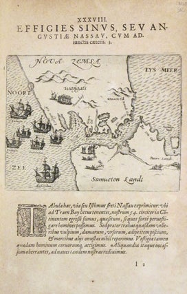
Frankfurt: Theodore De Bry, 1609. Map. Uncolored copperplate engraving. Sheet measures 12" x 8". This interesting map of Novaya Zemlya or Nova Zembla in Dutch, an archipelago in the Arctic Sea located just north of Russia. The map, centered on the Kara Strait (here noted as Fretum Nassau or Nassau Straits), covers the southern tip of the Novaya Zemlya and the northern tip of Vaygach Island. The map beautifully renders the topography and the sea, with seven Dutch ships making..... More
Surrey: Hancock House, 1986. Illustrated with some b/w photographs. 435 pages. Thick 8vo, blue printed wrappers (rubbed and with shallow reading creases in spine). Surrey: Hancock House, (1986). Very good. More
New York: Checkmark Books, 1999. Profusely illustrated in b/w and color throughout. 228 pages. 4to, navy cloth, d.w. (New York): Checkmark Books, (1999). A near fine copy in a very good wrapper--rear panel scratched and scuffed, light discoloration to front cover. More
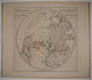
Amsterdam: J. Covens et C. Mortier. Map. Engraving with original hand outline. Image measures 18 1/8" x 17 7/8". Beautifully detailed map of the Northern Hemisphere, circa 1730. One of the most accurate depictions of the world at the time, Delisle correctly depicts California as a peninsula, though much of Eastern Asia, Russia and North America is yet unexplored. Toning and creasing to left and right edges. A few small tears to edges. Full original margins. Guillaume Delisle (1675-1726) was..... More
New York: Contemporary Publishing Company, 1894. Illustrated with b/w photos throughout. 241 pages. 8vo, green cloth. New York: Contemporary Publishing Co., 1894. A very good(+) copy--light fading to spine, some spotting to top edge of pages. More
Berlin: Reimer, 1904. 21 folding maps and plates, 400 text illustrations. 668pp. thick 4to, gray cloth backed pictorial boards; (ex-lib). Berlin, 1904. First edition. Very good. "valuable scientific results were obtained." J.N.L. Baker. More
With Descriptions of the Inner Life of the People, Their Manners and Customs. 250 text illus. 8vo, modern 3/4 morocco; (lacks map, rubbed, foxing). London: George Newnes, 1899. More
Recit d'un Voyage fait en 1856, sur le Yacht le "Foam" en Islande, a Jan Mayen et au Spitzberg... Traduit...par T.P. Bedard. mounted photo frontis. portrait, wood engraved text illus. 320pp. 8vo, 1/2 calf. Montreal, 1876. This French Canadian edition of Lord Dufferin's arctic travels not listed in NUC. More
Boston: Little Brown, 1973. Illustrated with a handful of b/w photos. 346 pages. 8vo, cloth-backed boards, d.w. Boston: Little Brown, (1973). A very good copy--light rubbing to spine and rear cloth, some foxing to fore-edge; in a very good wrapper, edgeworn. More
folding map of Hudson's Bay and the Canadian Arctic. 9 engraved plates, 5 folding. xxviii, 336pp. small 8vo, cont. calf; (spine ends worn, inner hinges strengthened). London: Whitridge, 1748. "Pt. 1 is a synopsis of twenty-three English voyages to discover the Northwest passage...pt. 2, an account of a voyage under Captains Moor and Francis Smith, financed by private subscription, with (Arthur) Dobbs the leading subscriber; the author, also a subscriber, was a hydrographer, surveyor and mineralogist on the expedition which..... More
many illus., a few in color. sq. 4to, cloth, d.w. Thomas Nelson, n.d., (ca. 1972). vg. More
New York: Grove, 2001. Illus. 8vo, white cloth, d.w. lightly soiled. New York: Grove Press, (2001). More
New York: Grove, 2001. 470 pages. 8vo, white cloth, d.w. New York: Grove Press, (2001). First American edition. A very good(-) copy--foxing on fore edge and a bit to edges of boards, some cloth loss from removed tape; in a near fine wrapper. More
Washington: Brassey's, 2000. New Introduction by James P. Delgado, 1908 introduction by Captain Scott. Illustrated. 291 pages, 8vo, blue cloth, d.w.; ink bookstore stamp on front free endpaper. Washington, D.C.: Brassey's, Inc., (2000). First edition. A fine copy in a fine dust wrapper. More
Color Frontis. 480pp. 12mo, orig. cloth; (head of spine and edges of corners worn, previous owner's notations on front flyleaf, some light foxing). N.Y.: D.W. Evans, 1860. More
Cleveland: World, 1962. Ed. by Dagmar Freuchen. Illus. 8vo, white cloth, d.w. and cloth lightly soiled. Cleveland: World, (1962). More
New York: Putnam, 1958. Illustrated, 438pp. 8vo, blue cloth, chipped d.w. New York: Putnam, (1958). very good in a very good(-) dust wrapper. Narrative of a year spent in the Arctic. More
New York: Dutton, 1961. Illustrated with a few in color. 8vo, blue cloth, pictorial d.w. New York: Dutton, (1961). First Edition. Top edge spotty, still a very good(+) copy. More
illus. 8vo, cloth, d.w.; (paint on front cover and d.w.). N.Y.: Dutton, 1955. More
New York: Norton, 1948. Frontis map, several b/w photos. 229 pages. 8vo, blue cloth, d.w. New York: Norton, (1948). A good copy--spotting to cloth and outer edges, even toning to endpapers, dampstaining to spine; in a good dust wrapper, tattered and foxed with chipping to rear cover. More
New York: Scribner, 1886. Nearly 100 Illus. 9 maps, 3 folding, including large folding map in back pocket of vol. II. 2 Vols. Thick 8vo, rebound in modern red cloth with leather labels, spines rubbed, otherwise very good. New York: Scribner's, 1886. First Edition From his camp, Fort Conger on Ellesmere Island, Greely discovered Lake Hazen and Greely Fjord. He reached the farthest north point yet at 83 degrees, 24'. Relief ships failed to reach Fort Conger so in 1883..... More
A fine website and a distinguished store. It's been a pleasure doing business with Argosy in the past and I look forward to more transactions in the future.
I've just received by post, this morning, the book I expected: "The Memory of Certain Persons", by John Erskine. Thank you very much, I'm very glad.