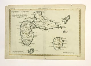
Les Isles de la Guadeloupe, De Marie Galante, De La Desirade
Paris: Rigobert Bonne. Map. Engraving with original outline coloring. Image measures 9.5 x 12.75". This map of the Guadeloupe Islands in the French West Indies is by one of the most significant French cartographers of the 18th century. After first reaching them in 1493, Christopher Columbus named the islands after the Virgin Mary, yet with their oft-remarked butterfly-like shape, they might have been better named for an angel. Bonne has elegantly rendered the shape and detail of the coastlines, including..... More