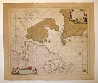
Pascaarte vande Noorder Zee custen van America Vande West-hoeck van Ysland doorde Straet Davis en Hudson, tot aen Terra Neuf.
Amsterdam: 1681. Sea chart. Copper plate engraving with original hand coloring. Image measures 19.5 x 23.25". Sheet measures 23 x 27". This wonderful sea chart speaks to 17th-century European interest in the uppermost parts of North America, and particularly Arctic Canada. The map shows the area around the entrance to Hudson Bay and the area of the supposed Northwest Passage. While the interior of most of the land depicted is little explored, the map offers substantial detail on the coasts..... More