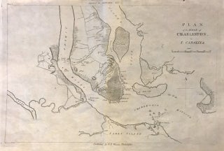
Plan of the Siege of Charleston in S. Carolina
Philadelphia: C. P. Wayne, 1807. Map. Uncolored engraving. Sheet measures 10.5 x 16.25". This important 1807 Revolutionary War - era map depicts the Siege of Charleston, one of the major engagements fought during the War. It covers from the Shipyard south to include Charleston Harbor and vicinity, as well as parts of James Island and Sullivan's Island. After suffering losses in the north, the British shifted their attention to the Southern Colonies and seized Savannah and Charleston by 1779. The..... More