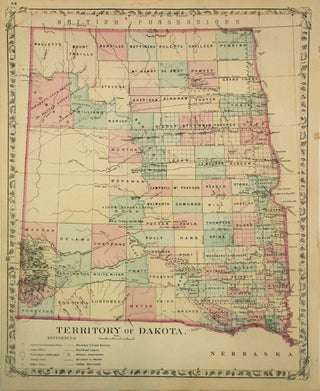
Territory of Dakota
Philadelphia: Samuel Augustus Mitchell Jr., 1879. Map. Lithograph with original hand coloring. Image measures 14.25 x 11.75". This 1879 map by Mitchell depicts the Dakota Territory before it was divided into two separate states of North Dakota and South Dakota. It shows details to the level of counties, towns, railways, roads, Indian Reservations, mountains, and other topographical features. The map is in good condition with minor foxing. Samuel Augustus Mitchell Sr. (1792-1868) was one of the leaders in American cartography..... More