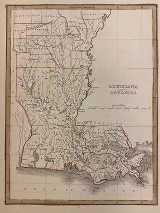
Louisiana and part of Arkansas
Boston: W.D. Ticknor, 1835. Map. Engraving with original hand outline. Image measures 7 3/4" x 10 1/4". Lovely map of Louisiana and Arkansas published in 1835. Hand colored to show early county divisions. Rivers, cities, and parishes are labeled. The Masserne Mountains, now known as the Ozarks, are depicted pictorially. Several Indian villages are noted - including Caddo, Coshatta, and Delaware. From "A Comprehensive Atlas Geographical, Historical and Commercial". Minor foxing to margins. T.G. Bradford (1802-1887) was a Boston based..... More