19TH CENTURY
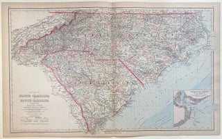
Frank's New Map of North Carolina and South Carolina
Philadelphia: O.W. Gray & Son, 1884. Map. Engraving with original hand coloring. Image measures 17 1/4" x 28 3/8" Large double-page map of of the Carolinas, divided into counties and townships. Shows all major towns and cities, routes, railroads and waterways. Topography and marshlands are impressively depicted, with relief shown by hachure. The coastline is rendered in great detail, with inlets, shoals, lighthouses, and other features labeled. This map includes an inset of Charleston Harbor and its approaches, including depths..... More
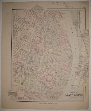
Gray's New Map of Saint Louis
Philadelphia: O.W. Gray & Son, 1883. Map. Engraving with original hand coloring. Image measures 15 5/8" x 13". Beautifully detailed map of St. Louis, colored according to wards. Shows street grid, railroads, parks, reservoirs and public institutions. Small tear and crease to right edge, light stain to left margin. More
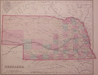
Nebraska
Philadelphia: Stedman, Brown & Lyon, 1877. Map. Engraving with original hand coloring. Image measures 11.75" x 14.75". Nice map of Nebraska divided into counties and townships. Shows towns, waterways and railroads. In excellent condition with only a very small chip to lower left corner. More
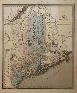
Maine.
Brattleboro: G. R. French, 1849. Map. Engraving with original hand coloring. Image measures 12 1/2" x 10 3/4" Classic map of Maine divided into counties. Shows many place names, major routes, railroads, waterways and topographical details. Greenleaf's delicate treatment of this map complements the natural beauty of Maine's geographical elements. Unlike earlier editions of this map, the northern boundary line is colored to its present-day border as established in the Treaty of 1842, previously labeled as "Boundary as recommended by..... More
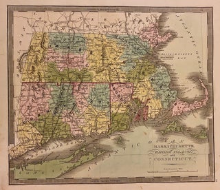
Massachusetts, Rhode Island, and Connecticut
Brattleboro: G. R. French, 1840. Map. Engraving with original hand coloring. Image measures 10 3/4" x 12 1/2" Classic first edition Greenleaf map of Massachusetts, Connecticut, and Rhode Island divided into counties. Shows many place names, major routes, railroads, waterways and topographical details. Includes the Long Island Sound and part of Long Island. In very good condition with one faint stain below Sakonnet Point, and some wear to lower left margin not affecting the image. Jeremiah Greenleaf (1791-1864) was an..... More
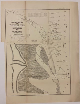
Plan and Section of the North Cut at Milwaukee No. 2
New York: Ackerman Lith. 1853. Map. Uncolored lithograph. Image measures 117" x 12 3/4" Nice sea chart of part of the Milwaukee Bay and Kinnikinnick River. Features geographical and topographical details, shipyards, canals, and government buildings. Left margin cropped, minor toning along original folds. More
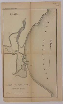
Plan No. 3 Milwaukee Harbor Improvement
New York: Ackerman Lith. 1853. Map. Uncolored lithograph. Image measures 15.5"x 9.5". Nice sea chart of part of the Milwaukee Bay. Features geographical and topographical details, shipyards, canals, and government buildings. Left margin cropped, minor toning along original folds. More
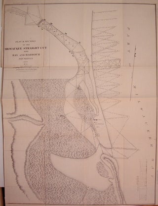
Plan & Section of the Milwaukee Straight Cut with Bay and Harbour Soundings
New York: Ackerman, J., 1853. Map. Uncolored lithograph. Image measures 23.75" x 18". Nice sea chart the Milwaukee River and Bay. Features geographical and topographical details, depths, town boundaries and some buildings. Missing left margin and minor toning along original folds. More
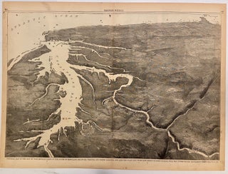
Pictorial Map of the Seat of War, Showing Parts of the States of Maryland, Delaware, Virginia, and North Carolina, and also the Coast Line From Cape Henry to Fort Pickens, with the United States Blockading Fleet
Harper & Brothers, 1861. View. Uncolored Wood engraving. Image measures 13 7/8" x 20 3/8". This double-page bird's eye view of the Chesapeake Bay region was published at the start of the Civil War. Looking southward from Maryland, the view extends along the Atlantic coast, showing the Florida panhandle in the distance. Cities are depicted pictorially, and ships are illustrated outside each major coastal city. A description on page 359 reads "We publish a large Birds-Eye View of the Seat..... More
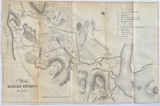
Map of Harlem Heights & Plain
New York: D. T. Valentine, 1856. Map. Engraving. Image measures 11" x 16 1/2" Fascinating map of Harlem in 1814, published in D. T. Valentine's Manual of 1956. Extending from the Hudson River to the fork of the Harlem and East Rivers, the map depicts the area during the War of 1812, showing fortifications erected to protect against British invasion. A key in the upper right labels these fortifications and other points of interest, including the Stone Tower on Hallet's..... More
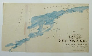
Map of Otsikwake or Black Lake, St. Lawrence County New York.
Map. Pen and ink with watercolor. Image measures 13 x 23". This pen and ink map of Black Lake in New York State was likely produced in the mid-19th century by a student or apprentice as training in geography, drafting, and penmanship. The lake, otherwise known at Otsikwake, is located in St. Lawrence County near the Canadian border. Significant locales are labeled in a fashion redolent of printed maps of the period, yet the idiosyncratic handwriting of the mapmaker gives..... More
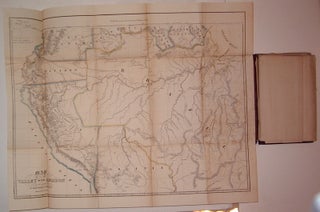
Herndon's Valley of the Amazon Maps. Part I.
U.S. Government, 1854. Case Map. Lithograph. Image measures 9.5" x 5.75". Case map of three maps pertaining to the Amazon River and it's surrounding area. Embossed cloth cover with gilt title; on the back is embossed "House Document". Some wear to spine and front cover, but all three maps are attached. First map is "Map of the Valley of the Amazon" (by H.C. Elliot), with lithographed color outline. Minor scattered foxing and stains from original glue to booklet. Measures 17.75"..... More
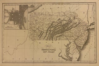
Map of the States of Pennsylvania and New Jersey
London: Hinton, Simpkin & Marshall, 1832. Map. Hand colored engraving. Image measures 15 1/2" x 10" Crisp map of Pennsylvania, New Jersey, and Delaware published in 1832. Includes an inset in the upper right corner showing a Plan of Philadelphia. Cities, towns, rivers, canals, and railroads are labeled. Topography is beautifully rendered by hachure. Isaac Taylor Hinton (fl. ca. 1828-1831) was a English printer and publisher. He collaborated with his brother, Reverend John Howard Hinton, on his 1832 publication "The..... More
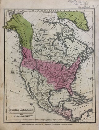
North America
Hartford: F.J. Huntington, 1830. Map. Engraving with hand coloring. 11.25" x 8.5". Some light wear at edges, image unaffected. In very good condition. A map of North America from the atlas The Malte-Brun School Geography by S. Goodwin Goodrich (Hartford, 1835). Shows Mexico extending from modern-day Texas to Utah and northern California, Alaska as Russian Possessions, and the United States extending north of Vancouver Island. More
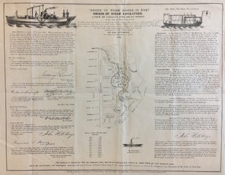
"Honor to Whom Honor is Due." Origin of Steam Navigation. A View of Collect Pond and its Vicinity.
New York: John Hutchings, 1846. Map. Lithograph. 14 1/2" x 18". Fascinating map of the section in lower Manhattan from Lispenard Street and Broadway, down to Warren and Centre Streets, where the Alms House was. The focus of the map is Collect Pond, centered at the intersection of Centre and Leonard Streets. Besides the map to the left are letters to John Hutchings certifying that a steam boat was seen on Collect Pond in 1796. To the right are remarks..... More
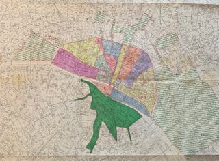
Plan de Paris
Paris: Institut Geographique National, 1956. Map. Lithograph with hand coloring. 40 1/2 x 50 1/2 inches. Large scale map of Paris and surrounding arrondissements. Manuscript notes in color with accompanying hand written notes,by the directorate of urban planning and technical services of topography and urban planning. Also includes the surrounding Bois de Boulogne and part of the Bois de Vincennes. Folded as issued, some paper clip rust and stains but otherwise in good condition. The Institut national de information geographique..... More
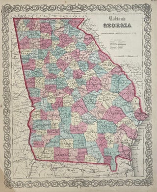
Colton's Georgia
New York: Johnson & Browning, 1856. Map. Steel engraving with original hand coloring. Image measures 12.75" x 15.5". Classic 1856 map of Georgia divided into counties and townships. Shows major towns, cities, routes, waterways and railroads. In very good condition. Minor toning and spots at margins, not affecting the image. Crease to lower left corner. Alvin Jewett Johnson (1827-1884) is one of the most prolific American publishers of the 19th century. He opened his own company in 1856 that produced..... More
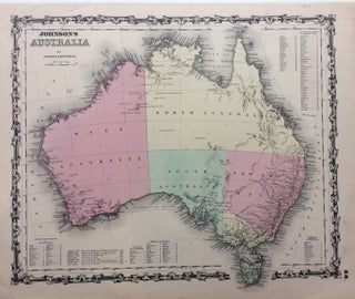
Johnson's Australia
New York: Johnson & Browning, 1861. Map. Engraving with original hand coloring. Image measures 12.5" x 15.5". Sheet measures 14" x 18". Shows some light foxing and staining. In very good condition. Largely unexplored interior reflected in this well designed map. Includes six reference keys noting counties and discoveries. Alvin Jewett Johnson (1827-1884) is one of the most prolific American publishers of the 19th century. He opened his own company in 1856 that produced atlases, maps and encyclopedias. The company..... More
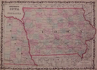
Johnson's Iowa and Nebraska
New York: Johnson & Browning, 1861. Map. Engraving with original hand coloring. Image measures 12" x 16.75". Nice map of Iowa and part of Nebraska, divided into counties. Shows towns, major routes, railroads and waterways. A few scattered chips and tears to edges, image unaffected. Alvin Jewett Johnson (1827-1884) is one of the most prolific American publishers of the 19th century. He opened his own company in 1856 that produced atlases, maps and encyclopedias. The company made great maps based..... More
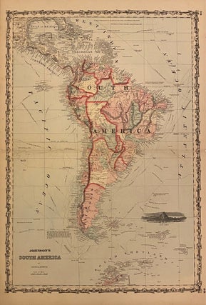
Johnson's South America
New York: Johnson & Browning, 1861. Map. Engraving with original hand coloring. Image measures 24 1/2" x 17". New York: 1861. Beautiful map of the continent extending from Gulf of Mexico to the South Shetland Islands. Includes black and white view of Cape Horn and paths and dates of historical explorations. Some splitting along centerfold, reinforced with archival tape. Otherwise in very good condition. A dark, crisp impression with vibrant hand-colored outlines. Alvin Jewett Johnson (1827-1884) is one of the..... More
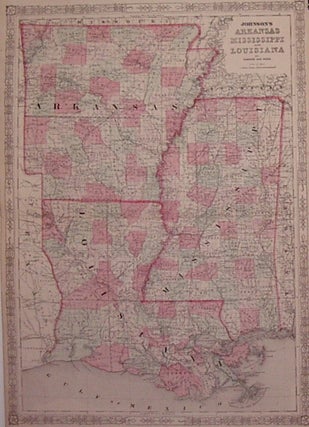
Johnson's Arkansas Mississippi and Louisiana
New York: Johnson & Ward, 1863. Map. Steel engraving with original hand coloring. Image measures 24.25" x 17.25". Classic map of Arkansas, Mississippi and Louisiana divided into counties and townships. Shows all major towns, cities, routes, waterways and railroads. Alvin Jewett Johnson (1827-1884) is one of the most prolific American publishers of the 19th century. He opened his own company in 1856 that produced atlases, maps and encyclopedias. The company made great maps based on those by J.H. Colton and..... More
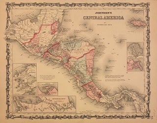
Johnson's Central America
New York: Johnson & Ward, 1863. Map. Engraving with original hand coloring. Image measures 12 1/2" x 15 1/2" Clear and detailed map of Central America published in 1863. An ornate decorative border surrounds the map. Includes views of The Isthmus of Panama, The Nicaragua Route, and the harbor of San Juan de Nicaragua, as well as grid plans of the City of Panama, and Aspinwall City on the island of Manzanilla. In very good condition. Archival tape repair to..... More
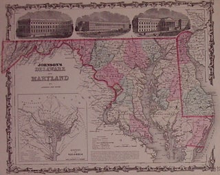
Johnson's Delaware and Maryland
New York: Johnson & Ward, 1863. Map. Engraving with original hand coloring. Image measures 12.5" x 16.25". Beautiful map of Delaware and Maryland showing counties, towns, major routes, railroads and waterways. Includes a black-and-white inset of the District of Columbia plus three detailed black-and-white views of the General Post Office, Treasury Buildings, and Patent Office. Alvin Jewett Johnson (1827-1884) is one of the most prolific American publishers of the 19th century. He opened his own company in 1856 that produced..... More
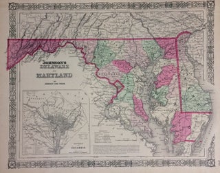
Johnson's Delaware and Maryland
New York: Johnson & Ward, 1864. Map. Engraving with original hand coloring. Image measures 12.75" x 15.75". Nicely detailed map of Delaware and Maryland showing counties, towns, waterways and railroads. Includes a black and white inset of the District of Columbia. A few small chips and tears to left edge. Alvin Jewett Johnson (1827-1884) is one of the most prolific American publishers of the 19th century. He opened his own company in 1856 that produced atlases, maps and encyclopedias. The..... More