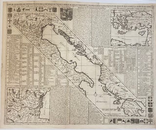
Carte Geographique des Diffrents Etats de la Republique de Venise,; L'Abrege de Son Gouvernement Politique et Ecclesiastique et les Etats ou Elle a Porte La Gloire De Ses Armes
Amsterdam: 1719. Map. Uncolored engraving. Map measures 20 3/4" x 25 3/8". Beautiful clear impression of the Gulf of Venice, including a gazetteer, coats of arms, and two insets showing the surrounding region and the eastern Mediterranean. Details the sites of important historical events, buildings and geographical features. Published in Chatelain's "Atlas Historique" in 1719. The map is in very good condition. Plate mark visible. Henri Abraham Chatelain (1684 - 1743) was a Dutch cartographer pastor best known for his..... More