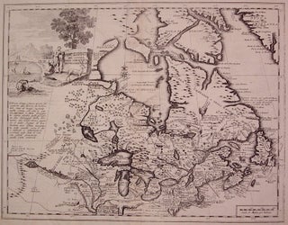
Carta Geografica del Canada Nell: America Settentrionale
Venice: Giovanni Battista Albrizzi, 1740. Map. Uncolored engraving. Image measures 13" x 16.75". Exquisite map of Canada showing the Great Lakes in detail with beautiful country vignette cartouche. Detailed explorers notes engraved throughout including Baron di Lahontan's accounts of the West. Some discoloration along centerfold and edges but in pleasing black and white state. Giovanni Battista Albrizzi (1698-1777) was a prominent Venetian publisher of books and maps. He inherited his business from his father and was part of a family..... More
![Item #308785 [Fools Cap Map] Afbeeldinge Van't Zeer Vermaarde Eiland Geks-Kop. ANONYMOUS](https://argosybooks.cdn.bibliopolis.com/pictures/308785.jpg?width=320&height=427&fit=bounds&auto=webp&v=1656538492)