
Il Seicento Francese
Milan: Fratelli Fabbri, 1971. 38 color plates, 46 b/w Illus. 96pp. 4to, gray cloth, d.w. (Milano): Fratelli Fabbri, (1971). Very good I Desegni dei Maestri No. 11. Drawings of French artists of the 17th century. More
Milan: Fratelli Fabbri, 1971. 38 color plates, 46 b/w Illus. 96pp. 4to, gray cloth, d.w. (Milano): Fratelli Fabbri, (1971). Very good I Desegni dei Maestri No. 11. Drawings of French artists of the 17th century. More
London: Cassell, 1995. Profusely illustrated in color. Slim 4to, blue cloth. (London): Cassell, (1995). Fine. More
New York: Metropolitan Museum of Art, 2008. 242 illustrations, including 232 in full color. 432 pages. Thick 4to, green cloth, d.w. New York: Metropolitan Museum of Art, (2008). A fine copy in a fine dust wrapper. Exhibition Catalog Metropolitan Museum of Art February 12-May 11 2008. Essays by Keith Christiansen, Anna Ottani Cavina, Alain Merot, Claire Pace, Rene Demoris and Willibald Sauerlander. Catalog by Pierre Rosenberg. More
Austin: University of Texas, 2014. Translated from the French by Susan Emanuel. Illustrated in color and in black and white. xiv, 357 pages. 8vo, blue cloth, d.w. (minor edgewear). Austin: University of Texas Press, (2014). First English language Edition. Inscribed by the author at title page. An uncommon title. A fine copy in a near fine dust wrapper. More
New York: Frederick Ungar, 1964. Two volumes. Translated by Katherine Wormeley. Illustrated in black and white. 464 and 446 pages. 8vos, yellow cloth, dust wrappers. New York: Frederick Ungar Publishers, (1964). Wrappers lightly edge-worn, previous owner's signature on flyleaf; a near fine copy in very good wrappers. More
Ann Arbor: UMI, 1982. Illustrated. 536 pages, 8vo, decorative beige cloth. (Ann Arbor): UMI, (1982). Fine. Studies in Musicology, No. 56. More
New York: Metropolitan Museum of Art, 1992. Illustrated in color and b/w. 287 pages. 4to, pictorial wrappers. (New York): Metropolitan Museum of Art, (1992). A very good(+) copy with light spine creasing and toning. More
![Item #272805 [Lemnos. Hellespont]. George SANDYS](https://argosybooks.cdn.bibliopolis.com/pictures/272805.jpg?width=320&height=427&fit=bounds&auto=webp&v=1485291158)
London: George Sandys. Miniature map. Colored engraving. Sheet measures 10.25" x 7". London: Sandys, 1615 This lovely circa 1615 map depicts the Hellespont or the Dardanelles, a narrow strait northwest of Turkey. Oriented with north at the bottom, the map covers the Gallipoli Peninsula or the Thracian Chersonese and part of the Asian section of northwest Turkey. Includes the island of Imbros or Gökçeada. The seat of the ancient city of Troy is also marked. The Dardanelles separates Asian Turkey..... More
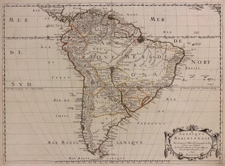
Paris: Pierre Mariette, 1650. Map. Engraving with original outline color. Image measures 15 3/4" x 21 3/4" This exceptionally fine map of South America covers the continent in fine detail. Coastlines are extensively labeled, and mountains beautifully rendered in profile. The Orinoco and Amazon Rivers, as well as Rio de la Plata, are prominently rendered. Sanson refrains from drawing a southern coastline to Tierra del Fuego, and the relatively unknown Amazon region is depicted in minimal detail. Sanson does, however..... More
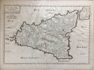
Paris: 1663. Map. Hand-colored engraving. 15" x 23". This map of Sicily from the 17th century shows the entire island as well as the southwesternmost tip of the Italian peninsula. The names of the surrounding bodies of water are named in Latin and rivers, mountains, lakes, and towns are noted on the map. Nicolas Sanson (1600-1667) is considered the founder of the French school of cartography. In reaction to the prevailing trend of Dutch lavishness, Sanson favored minimal details, focusing..... More
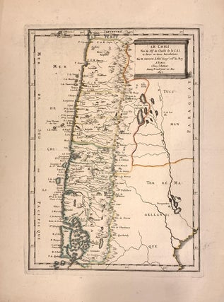
Paris: 1657. Map. Original outline coloring. Sheet measures 14.5 x 10.5". Image measures 10.5 x 7.25". Paris: Nicolas Sanson, (1657). 2nd small Edition. As the title notes, this fine map of Chile is based on Jesuit Alonso de Ovalle's, large map of Chile. From Sanson smaller version of the map. Beautifully engraved with the Andes shown pictorially. In very good condition. Nicolas Sanson (1600-1667) is considered the founder of the French school of cartography. In reaction to the prevailing trend..... More
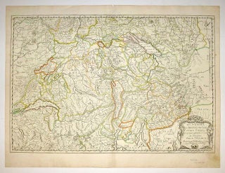
Paris: 1648. Map. Engraving with hand outline color. Image measures 14.5 x 21.5 inches. This map of Switzerland centers on Lucerne, covering approximately the area from Lake Constance south to Lake Como in Italy. Published in 1648, the map dates to the period of the Old Swiss Confederacy. Furthermore, it predates by only a few years the Swiss Peasant War of 1653, a siege of Lucerne and Bern that demonstrated the significance of the rural population to the confederacy's stability..... More
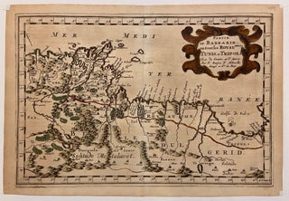
Paris: 1683. Map. Copper engraving with hand coloring. Image measures 7 5/8 x 11 1/4 inches. This map, published in Paris in Afrique en plusieurs cartes, is one of Sanson's small atlas maps of depicting various African regions. This map offers extensive detail on the cities of North Africa, as well as topographical and geographical features with mountains beautifully rendered in profile. Nicolas Sanson (1600-1667) is considered the founder of the French school of cartography. In reaction to the prevailing..... More
Ann Arbor: UMI Research Press, 1982. 100 Illus. 8vo, tan cloth. Ann Arbor: UMI Research Press, (1982). Near Fine Study of Peter Paul Ruben' Medici Cycle in the Louvre, representing the life of Marie de'Medici. More
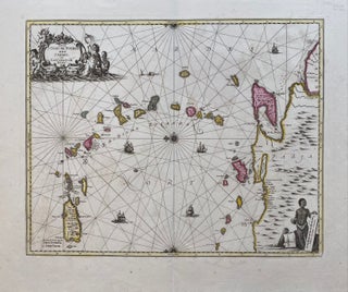
Amsterdam: Schenk, 1700. Map. Copper plate engraving with original hand color. Published 1700. Image measures 19" x 22 1/4". This rare and beautiful sea chart of the West Indies with north oriented to the left, features the Windward Islands. Puerto Rico to Trinidad and the Coast of Venezuela are included with part of Guiana. The elaborate title cartouche, with mermaids and mermen, is finely painted with original coloring. The scale cartouche features an indigenous trader with coils of tobacco and..... More
Basel: Bertschl, 1683. 20 pages Slim 8vo, modern wrappers. Basileae: Jacobi Bertschl, 1683. A very good copy. Fine copy of this early inaugural disputation at Basel, by a native of Switzerland, on lientery. More
Paris: Bibliotheque de la Pleiade, 1992. 3 volumes. Text in French. 12mo, flexible gilt-decorated red leather. Paris: Gallimard/Bibliotheque de la Pleiade, (1992). A very good(+) set-- first volume has faded topstain and is lacking a slip cover; second and third volume have ownership inscriptions. "Bibliotheque de la Pleiade" series. More
Ann Arbor: UMI Research Press, 1982. 8vo, tan cloth with orange and black stamping. Ann Arbor: UMI Research Press, 1982. A fine copy. More
New York: St. Martin's, 1974. Illustrated sparsely in black & white. 200pp. 8vo, green boards, slightly edge-worn d.w. New York: St. Martins, (1974). A near fine copy in a very good(+) dust wrapper. More
New Haven: Yale University Press, 1995. 240 illustrations in color & in black & white. 4to, black cloth, d.w. New Haven: Yale University Press, (1995). First Edition. Fine. More
Paris: Chez Augustin Courbe, 1656. Extra engraved title page, and illustrated with a portrait, "Dedie a la Serenissime Reyne de Suede", and 10 finely engraved plates. [44], 380, [15] pages with red edges. 12mo, plain contemporary vellum with envelope edges. Paris : Chez Augustin Courbe, 1656. A near fine very clean copy of this early printing. OCLC lists 11 copies of the Paris edition. According to Brunet, some copies have imprint: Impr. a Bruxelles. F. Foppens M.DC.LVI -- Willems, Les..... More
London: John Stuart, 1695. 33 copper engraved plates including title page. Slim oblong 4to, - contemporary 3/4 calf with marbled boards and inlaid title and date on front cover. Covers are detached, title page soiled and chipped, covers detached, backstrip lacking. Several water stains (in margins, one plate with a margin repaired). Many plates in nice clean condition and several soiled, some slight foxing. Lacks engraved portrait. London: John Stuart, 1695. A scarce well used rarity. He was hailed by..... More
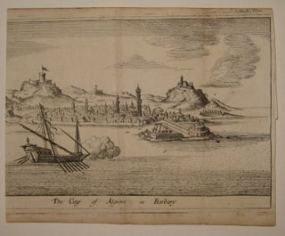
London: 1690. View. Uncolored etching. Image measures 4 5/8" x 7 1/16". Charming panoramic view of the port of Algiers, circa 1690. The harbor view shows several ships as well as buildings and hills in the background. John Seller (c. 1630-1697) was an English instrument maker and cartographer and in 1671 he was appointed Hydrographer to the King. Seller instigated the first English maritime atlas, in an effort to compete with the successful Dutch maps at the time. This print..... More
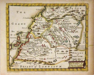
London: J. Seller. Miniature map. Copper plate engraving with hand coloring. Image measures 4 3/4" x 5 3/4". This charming miniature map of the Kingdoms of Tesset, Darha and Segelomess covers the northwestern part of Africa includes Morocco and parts of modern day Western Sudan, Algeria and Mauritania. Depicts part of the Barbary Coast including the Canary Islands. Incredibly detailed, the map notes several important cities, towns, waterways and beautifully rendered topography. During this time, the Barbary Pirates operated in..... More
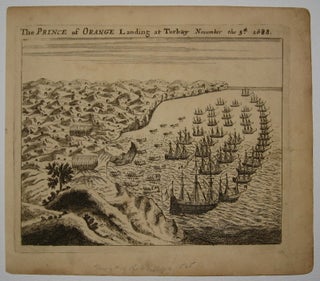
London. View. Uncolored engraving. Plate measures 4 11/16" x 5 7/8". View of William of Orange arriving at the English coast at Torbay in his claim for the British crown. John Seller (c. 1630-1697) was an English instrument maker and cartographer and in 1671 he was appointed Hydrographer to the King. Seller instigated the first English maritime atlas, in an effort to compete with the successful Dutch maps at the time. This print was published in "A New Systeme of..... More
I wanted to let you know that the Lehár autograph quotation arrived safe and sound having made its transatlantic journey without any problems. It’s a beautiful thing, and I can’t wait to get it up on the wall. I’m absolutely delighted with it – thank you!
Wow!! The book arrived this morning; I was not expecting it for weeks. Just in time for my birthday! Superb service; I shall certainly use your store again. Best wishes