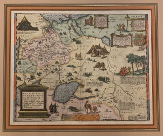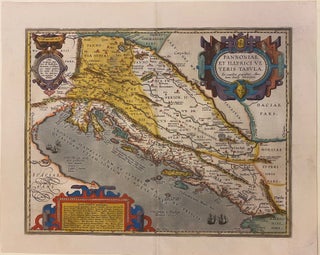
Pannoniae et Illyrici Veteris Tabula
Antwerp: Abraham Ortelius, 1595. Map. Engraving with original hand coloring. Image measures 14" x 18 1/8". Sheet measures 17" x 21 3/8" Beautifully colored map of the classical regions of Pannonia and Illyria (Dalmatia), lying on the northeastern coast of the Adriatic Sea. Depicts present-day Croatia, Bosnia and Herzegovina, and Montenegro. Shows classical place names, topographical and geographical features. Latin text on verso. From "Theatrum Orbis Terrarum". Light scattered stains to margins and cartouche. Minor abrasion to upper right. Abraham..... More