
The Land And Wildlife Of South America.
color and b/w illus. 4to, pict. boards. New York, (1964). vg. Life Nature Library. More
color and b/w illus. 4to, pict. boards. New York, (1964). vg. Life Nature Library. More
maps. 4to, cloth. Paris, 1928. More
Barcelona: Ediciones, 1989. Numerous illustrations in color and in black & white. 443 pages, thick 4to, cream cloth, d.w. (Barcelona): Ediciones Poligrafa, S.A. (1989). Fine in fine dust wrapper. More
Paris: Alexis Eymery, 1815. Folding map of Brazil with hand colored outlines. Two copperplate frontispieces. 3 volumes. 8vo, rebound in modern brown library cloth, ex libris stamps on title pages and the blank side of the map and the two plates, page margins uncut. Paris: Alexis Eymery, 1815. First Edition. With original wrappers and half-titles bound in each volume. Map has two small tears on right margin with no loss of text and that side has a small repair with..... More
New York: New York Zoological Society, 1917. Introduction by Theodore Roosevelt. Numerous black & white illustrations, one in color. 504 pages, printed on coated paper. Tall 8vo, gilt-stamped pictorial green cloth, t.e.g. New York: New York Zoological Society, 1917. Fine. More
Englewood Cliffs: Prentice-Hall, 1979. 8vo, white boards. Englewood Cliffs: Prentice-Hall, (1979). Very good. More
illus. 8vo, cloth, d.w. N.Y.: Monthly Review, 1963. The influence of the Cuban revolution on South America in 1962. vg. More
Paris: 1763. Map. Engraving with hand coloring. Image measures 8 3/4 x 11 7/8". Beautiful map of the NE Coast of Brazil. As noted by Bellin, "the interior of the country is not known; the wandering nations which inhabit it are named Tapuyas." Minimal toning. Jacques Nicolas Bellin (1703-1772) was the official hydrographer to the French king and the first person to hold the title of "Ingenieur de la Marine of the Depot des cartes et plans de la Marine"..... More
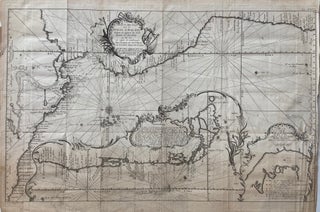
Paris: Jacques Nicolas Bellin, 1753. Sea Chart. Uncolored copper plate engraving. Image measures 8" x 11". Jacques Nicolas Bellin (1703-1772), was the official hydrographer to the French king and the first person to hold the title of "Ingénieur de la Marine of the Depot des cartes et plans de la Marine" (chief engineer of the French Hydrographical Office). More
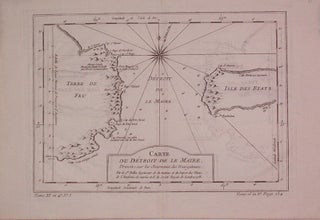
Paris: 1763. Map. Engraving with hand coloring. Image measures 8 3/8" x 6 1/2" Elegant map of the Straits of Magellan, Patagonia and the southern part of the Andes Mountains. Jacques Nicolas Bellin (1703-1772) was the official hydrographer to the French king and the first person to hold the title of "Ingenieur de la Marine of the Depot des cartes et plans de la Marine" (chief engineer of the French Hydrographical Office). More
1771. Map. Engraving. 12 7/8 x 20 7/8 inches. Unusual Dutch edition of Bellin's map of Mexico, Central America, and the west coast of South America, with large inset of its southern portion including Patagonia and the Straits of Magellan, and a smaller inset of the Baai van St. Francois on the tip of Tierra del Fuego. The Galapagos Islands are nicely featured. Folded as issued, repairs to right margin and right margin trimmed. Jacques Nicolas Bellin (1703-1772), was the..... More
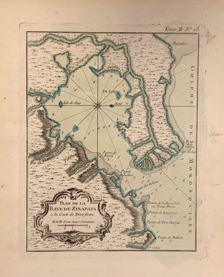
Paris: Jacques Nicolas Bellin, 1764. Map. Uncolored engraving. Image measures 8 3/4" x 6 1/2" Lovely nautical chart of the Bay of Cispata, Colombia. Indicates depths by soundings. Points, rivers, and islands are labeled. Jacques Nicolas Bellin (1703-1772), was the official hydrographer to the French king and the first person to hold the title of "Ingenieur de la Marine of the Depot des cartes et plans de la Marine" (chief engineer of the French Hydrographical Office)... More
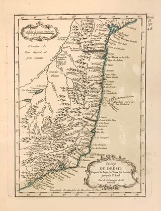
Paris: 1763. Map. Engraving with hand coloring. Image measures 8 7/8" x 6 3/4". Coastal map of Brazil from Baye de Tous les Saints to S. Paul Santos. includes Spiritu Santo and Rio Janeiro. Jacques Nicolas Bellin (1703-1772) was the official hydrographer to the French king and the first person to hold the title of "Ingenieur de la Marine of the Depot des cartes et plans de la Marine" (chief engineer of the French Hydrographical Office). This edition unusual edition..... More
illus. 8vo, cloth, d.w. N.Y.: Knopf, 1970. vg. More
New York: Aristide D. Caratzas, 1987. 79 pages. Slim 8vo, burgundy cloth with silver lettering. New Rochelle: Aristide D. Caratzas, (1987). Reprint of the original 1912 edition. Fine. More
New York: Museum of Modern Art, 1954. Frontispiece. Several color plates; profusely illustrated with black-and-white plates. 187 pages, 8vo, gray cloth. New York: The Museum of Modern Art, (1954). Very good. More
San Antonio: San Antonio Museum of Art, 2005. Extensively illustrated, including 114 full page color portraits. 303pp., 4to, glossy pictorial wrappers; ownership signature inside front cover. San Antonio: San Antonio Museum of Art, (2005). A near fine copy. More
illus. 8vo, cloth, d.w.; (ex-lib). London: Weidenfeld & Nicolson, (1962). More
New York: Museum of Modern Art, 2015. Profusely illustrated throughout, much in color. 320 pages. Small folio, tan cloth, d.w. New York: Museum of Modern Art, 2015. First edition. A fine copy, as new in the original shrinkwrap. More
8vo, cloth, d.w. N.Y.: Harper, (1962). vg. More
615pp. 8vo, cloth, torn d.w. New Rochelle: Arlington, (1969). More
Cambridge: Cambridge University Press, 1995. 645pp. 8vo, black cloth, d.w., pages throughout are slightly wavy, otherwise very good. (Cambridge): Cambridge University Press, (1995). More
Cambridge: Cambridge University Press, 1995. 1043pp. 8vo, black cloth, d.w., many pages slightly wavy, otherwise very good. (Cambridge): Cambridge University Press, (1995). More
Nashville: Vanderbilt University Press, 2016. Some black & white photographic illustrations. 290 pages. 8vo, red cloth-backed white boards, pictorial d.w. Nashville: Vanderbilt University Press, (2016). Corners slightly bumped. A near fine copy in a near fine dust wrapper. More
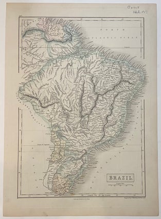
Edinburgh: A. & C. Black, 1851. Map. Color lithograph. Image measures 15" x 10 1/4" This lovely map of the Brazil was published in 1851 in Black's General Atlas of the World. The map is labeled in great detail, showing rivers, towns, mountains, and coastal features. Delicately colored to show national boundaries, including neighboring Uruguay, Paraguay, and British Guayana, Dutch Guyana, and French Guyana. The map is in excellent condition. Adam Black (1784-1874) was a Scottish publisher and politician who..... More
I want to especially thank and commend the person there who wrapped and packaged this volume for shipping. I have only rarely seen it done with such conscientious skill!
Just wanted to say thank you for a great book. It was in great condition (exactly as described) & was packaged well... Keep up the good work and we continue to buy online!