
The Yukon and Northwest Territories.
color and b/w illus. 8vo, cloth, d.w. Toronto: Macmillan, 1969. vg. More
color and b/w illus. 8vo, cloth, d.w. Toronto: Macmillan, 1969. vg. More
Seattle: University of Washington Press, 2001. Illustrated with b/w and color images. 196 pages. Slim oblong 8vo, blue cloth, d.w. Seattle: University of Washington Press/Canadian Museum of Civilization, (2001). Fine in fine dust wrapper. More
New York: Carroll & Graf, 2002. Illustrated. viii + 328 pages, 8vo, boards, d.w.; browning and spotting to top and foredges, not effecting text. Carroll & Graf, (2002). Text clean and unmarked, a very good copy in a very good dust wrapper. More
New York: Knopf, 2007. 268 pages. 8vo, black boards, dust wrapper. New York: Knopf, (2007). A near fine copy in a very good(+) dust wrapper. Tells the story of Inuit relocation by the Canadian government through the life of the illegitimate son of Robert Flaherty, the famed filmmaker of Nanook of the North. More
London: Weidenfeld, 1976. Illusttrated. tall 8vo, grey cloth, d.w. London: Weidenfeld, (1976). Very good (+). More
New York: Harper, 1931. Ed. by M. I. Ross. Color Frontis., b/w Illus. 8vo, original blue cloth, cloth soiled, ex-lib, lettering on spine faded, spine sunned. New York: Harper, 1931. More
New York: McElderry, 1996. Illustrated. 181 pages, 8vo, cloth-backed boards, d.w.; slightly cocked. New York: Margaret K. McElderrry Books, (1996). First edition. A near fine copy in a very good(+) dust wrapper. More
illus. 8vo, cloth; (corners bumped). London: Travel Book Club, n.d. More
8vo, cloth. Philadelphia: Lippincott, 1970. vg. More
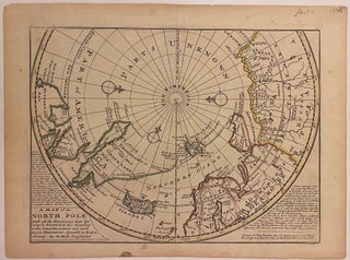
London: Thomas Bowles. Map. Engraving with original hand coloring. 9" x 18". Shows verso repair along one of two original fold lines, otherwise in very good condition. Beautiful 1730 chart of Arctic Circle depicting the eastern half of North America, northern Europe, and northern Asia. Notations describe European voyages to the region. A route from Japan to Porto, Portugal is depicted. Herman Moll (c. 1654-1732) settled in London in the 1670's where he worked as an engraver for Moses Pitt..... More
illus. 8vo, cloth. N.Y.: McBride, (1939). vg. More
New York: Century, 1926. Illus. 8vo, original green cloth, spine toned to tan, spine ends worn, ex-lib with usual markings. New York: Century, (1926). More
Toronto: McClelland and Stewart, 1967. Illustrated in color throughout. 302 pages. Tall 4to, gray cloth. (Toronto): McClelland and Stewart, (1967). A very good(+) copy, lacking the dust wrapper. More
2 vols. 8vo, library buckram; (lacks map, lower half of t.p. of vol. II lacking). London: Longman, 1829. "This work contains a vast amount of information regarding the condition of the aborigines of America, before it was modified by association with Europeans and a Bibliography of Voyages and Travels in America." Field 1113. Howes M-914. More
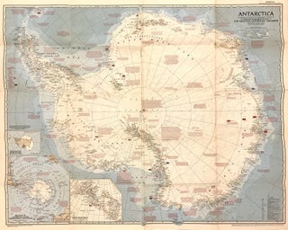
Washington, D.C. National Geographic Society, 1957. Map. Full-color lithograph. Sheet measures 23 3/4" x 21 1/2" Fascinating map of Antarctica. Highly detailed with notations describing the extent of international expeditions on the continent, with flags representing their respective stations. It features an Azimuthal Equidistant Projection executed by James M. Darly, Chief Cartographer, under the editor Melville Bell Grosvenor. Appeared in the September 1957 issue of National Geographic Magazine. This map is in good condition, with minor toning and wear along..... More
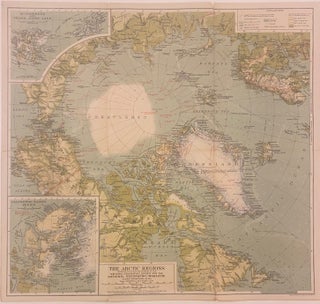
Washington, D.C. National Geographic Society, 1925. Map. Full-color lithograph. Sheet measures 18" x 19 1/8" Fascinating map of the Arctic, featuring an Azimuthal Equidistant Projection, colored to show elevation. The map was published by the map department of the National Geographic Society for the magazine, under editor Gilbert Grosvenor, and it appeared in the November 1925 issue of National Geographic Magazine. Two insets feature conical projections depicting Spitsbergan and Franz Josef Land, and the Ellesmere Island Region. Cities, towns, islands..... More
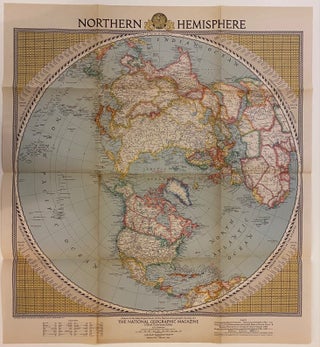
Washington, D.C. National Geographic Society, 1946. Map. Full-color lithograph. Sheet measures 23 3/4" x 21 1/2" Beautiful map of the world centered on the Arctic Ocean. It features an Azimuthal Equidistant Projection executed by the National Geographic map department under the editor Gilbert Grosvenor. Includes airline distances from various points in the Atlantic, Pacific, across the Americas, and across the Arctic. Appeared in the February 1946 issue of National Geographic Magazine. This map is in good condition, with wear and..... More
color illus. 8vo, cloth, d.w.; (d.w. lightly soiled). N.Y.: Morrow, (1999). Presentation copy. More
Athens: Ohio University Press, 1966. Maps. 425pp. 8vo, tan cloth, d.w. and cloth lightly soiled, d.w. chipped. (Athens: Ohio University Press, 1966). More
New York: Putnam, 2002. Illustrated with some black and white photographs. 184 pages. 8vo, tan boards, dust wrapper (flaps glued down to endpapers). New York: Putnam, (2002). A very good ex-library copy, stamp on copyright page, some discolorations on endpapers. More
New York: Putnam, 2002. Some black & white photographic illustrations. 184 pages. 8vo, tan boards with gilt lettering, pictorial d.w. New York: Putnam, (2002). A near fine copy in a near fine dust wrapper. More
San Francisco: Sierra Club, 2000. Illustrated abundantly in color. xxv, 102 pages. Square 4to, black cloth with silver lettering, d.w. (lightly edgeworn). San Francisco: Sierra Club, (2000). Fine in a very good(+) dust wrapper. More
New York: Talk Miramax Books, 2001. Illus. 8vo, 1/2 blue cloth, d.w. lightly soiled. New York: Talk Miramax Books, (2001). More
New York: Hyperion, 2000. Illustrated. xiv + 402 pages, 8vo, cloth-backed boards, d.w. New York: Hyperion, (2000). First edition. A near fine copy in a very good dust wrapper. More
New York: Macmillan, 1882. Translated by Alexander Leslie. 10 lithographed folding maps, some in color. 4 steel engraved portraits, 298 woodcuts. xxvi, 756pp. 8vo, original green cloth, spine ends and edges of corners lightly worn, edges of covers rubbed, corners bumped. New York: Macmillan, 1882. First American Edition Lacks frontispiece portrait of the author. A large folding map has a large tear and is chipped on the margin with no loss of text. Another folding map has a chipped margin..... More
I just finished reading about the store and your family in Nick Basbanes newest book, Patience & Fortitude. I had previously read an article in Book magazine. I wished that I lived near so I could visit your store, it looks and sounds like a place I dream of getting lost in. Basbanes book mentioned that your father began a memoir but was, sadly, unable to finish the work. Would it be in anyway possible to read what must be a great historical adventure in bookselling? I wish you all continued success and a very long existence.
I have just safely received my latest purchase from Argosy Book Store. The packaging for my last two orders has been excellent and I look forward to ordering again soon!