A Dictionary of British History.
New York: Stein and Day, 1983. 410 pages, 8vo, cloth-backed boads, d.w. New York: Stein and Day, (1983). A very good copy in a very good dust wrapper. More
New York: Stein and Day, 1983. 410 pages, 8vo, cloth-backed boads, d.w. New York: Stein and Day, (1983). A very good copy in a very good dust wrapper. More
North Pomfret: David & Charles, 1979. Illustrated. 160 pages, thin 8vo, black cloth, d.w. North Pomfret: David & Charles, (1979). A fine copy in a very good dust wrapper. More
New York: Carroll & Grad, 1993. Illustrated in black & white. 400 pages. 8vo, 1/2 black cloth, d.w. (minor scuffs). New York: Carroll & Graf, 1993. Near fine. More
New York: Putnam, 2007. Illustrated in black and white. 370 pages. 8vo, two toned boards, d.w. New York: Putnam, 2007. A very good(+) copy. More
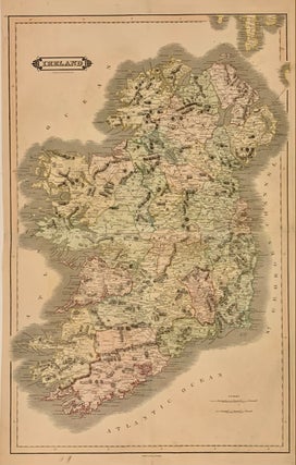
Edinburgh: Lizars, William, 1832. Map (diptych-north and south joined, image measuring 32 x 20 1/2 inches). Engraving with original full hand coloring and peach color border. Beautifully detailed map of Ireland. Colored by counties. Towns, rivers, lakes, and mountains are noted. William Home Lizars (1788--1859) was an engraver and painter based in Edinburgh. After the death of father, Daniel Lazars, he took up the family engraving business and expanded into etching and copperplate printing. This lovely map is a fine..... More
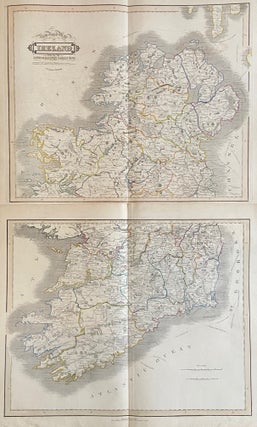
Edinburgh: Lizars, William, 1832. Map (diptych-north and south). Engraving with original hand outline coloring. Each image measures 16.5" x 20.75", each page measures 19" x 22.5". Beautifully detailed map of Ireland with rail and ship lines and distances. Ink manuscript pagination. Some offsetting and light stains but overall in good condition. Can be joined to form a large map. William Home Lizars (1788--1859) was a Scottish engraver and painter based in Edinburgh. After the death of father, Daniel Lizars, he..... More
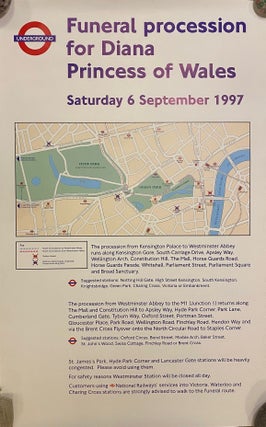
London: London Underground, 1997. Posters, set of 2 in original triangle tube. Measure 39 3/8" x 25" each. Informational posters issued by the London Underground in preparation for the funeral procession of Princess Diana on September 6, 1997. Features a map of west London showing the route of the procession from Kensington Palace to Westminster Abbey. Additional text offers information regarding station closures, anticipated congestion, and suggested alternative routes. In excellent condition, with original packaging. More
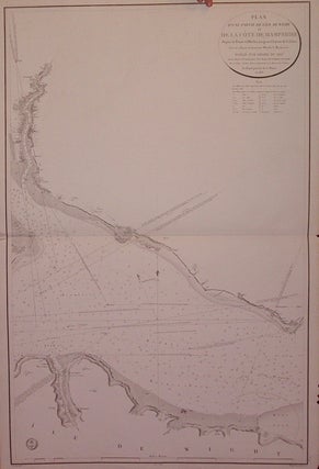
Paris: Depot General de Marine, 1823. Sea chart. Uncolored engraving. Image measures 36.75" x 24". French edition based on Mackenzie's map of 1783. Some chipping along right edge and two small tears to left edge. More
New York: Atlantic Monthly, 2000. Illustrated. xviii + 734 pages, thick 8vo, black boards, d.w. New York: Atlantic Monthly Press, (2000). First American edition. A near fine copy in a very good dust wrapper. More
Boston: Little Brown, 1983. Illustrated in black and white. xv + 973 pages, thick 8vo, black cloth, d.w. (yellowed, edgeworn) Boston: Little, Brown and Company, (1983). A near fine copy in a very good dust wrapper. More
Readex, 1966. Thin 12mo, red cloth. Readex Microprint Corporation, (1966). Internally fine, a very good(+) copy. Facsimile of the 1635 edition. Printed to attract settlers to the new province of Maryland. More
New York: Dorset, 1990. 224 pages, 12mo, cloth-backed boards, d.w. New York: Dorset Press, (1990). A very good(+) copy in a very good dust wrapper. More
Pleasantville: Reader's Digest, 1995. Color and black & white illustrations. 192 pages. 4to, glossy pictorial boards, pictorial d.w. (scuffed at the front and rear flap). Pleasantville: Reader's Digest, (1995). A near fine copy in a near fine dust wrapper. More
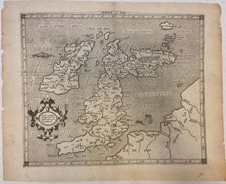
Cologne: Petrus Bertius, 1618. Map. Engraving with hand coloring. Sheet measures 19 5/8" x 15 3/4". This ancient map of the British Isles issued by Gerard Mercator was first published in the 1584 edition of Tablae Geographicae. This Ptolemaic map includes the present-day United Kingdom, Ireland, and shows parts of France and Germany. The map includes an ornate title cartouche and a sea monster that appears to be a cross between a bird and a fish. Important towns and cities..... More
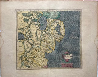
Amsterdam: Jodocus Hondius, 1612. Map. Engraving with hand coloring. Image measures 13 1/4 x 15 inches. Sheet measures 18 x 22 inches. Stains and chips to margins but otherwise in good condition. Beautiful map of the eastern part of Ulster, featuring Down and Antrim Counties in Northern Ireland. Mercator's famous moire pattern in the sea is used and relief is shown pictorially. The map appears in the French edition of the Mercator-Hondius Atlas. Gerard Mercator (1512-1594) was an accomplished mathematician..... More
New York: Doubleday, 2016. Illustrated. xi + 381 pages. 8vo, burgundy cloth-backed boards, d.w. New York: Doubleday, (2016). First edition. A fine copy in a near fine dust wrapper. More
New York: Harcourt, 1960. xiii, 334 pages. 8vo, black cloth-backed boards, d.w. (several tears with tape repair, chips at head). New York: Harcourt, Brace, (1960). First Edition. Upper corners bumped and some staining around outer edges of text block -- internally clean. A very good(+) copy in a very good(-) dust wrapper. More
New Haven: Yale University Press, 1982. Illustrated in color and black and white. 278 pages, small 4to, burgundy cloth, dust wrapper. New Haven: Yale University Press, 1982. Fine. The "...first book to chart the development of the terraced house from the later Georgian period through Regency splendor to Victorian and Edwardian times." More
New York: McGraw-Hill, 1966. With a handful of b/w and color maps. 1200 pages. Thick 12mo, red boards. New York: McGraw-Hill, (1966). Second edition. A very good copy(+), light sunning to spine with text slightly faded. More
New York: Grove, 2009. Illustrated. xvi + 302 pages, 8vo, maroon boards, d.w.; minor bumping to spine ends. New York: Grove Press, (2009). First American edition. A near fine copy in a very good(+) dust wrapper. More
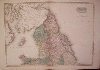
London: Cadell & Davies, 1811. Map (diptych-north and south). Engraving with hand coloring. Northern image measures 19.75" x 27.75", and page measures 22" x 32.75". Southern image measures 19.75" x 28.25" and page measures 27.75" x 32.5". From "Pinkerton's Modern Geography". Small chip to top of southern page edge. More
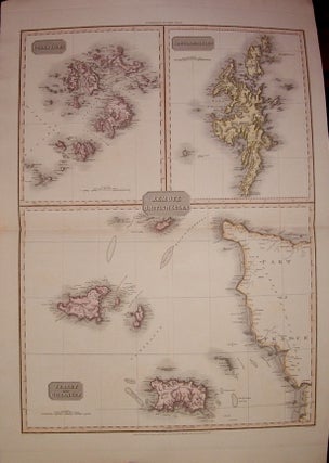
London: Cadell & Davies, 1814. Map. Engraving with original hand coloring. Image measures 27.5" x 19.75. Page is divided into three separate maps: "Scilly Isles", "Shetland Islands" and "Jersey and Guernsey". From "Pinkerton's Modern Geography" More
Canterbury: Canterbury City Council Museums, 1992. Illustrated black and white. 48 pages. Slim 4to, pictorial wrappers, staple-bound. Canterbury: Canterbury City Council Museums, 1992. First edition. Near fine condition. More
London: Batsford, 1938. Four volumes. Hundreds of illustrations, including many full-page color plates. 8vo, pale blue cloth with pictorial covers. London: B. T. Batsford, (mixed set published between 1933 & 1938). A very good(+) set. Volume I: 1066-1499; Volume II: 1500-1799; Volume III: 1733-1851; Volume IV: 1851-1934. More
The book arrived today in Luxembourg - great packaging and a very nice copy, true to the description. Thanks for the great customer service.
The book has arrived and all is well. Thanks for a nice sale!