
Edward Wortley Montagu, 1713-1776: The Man in the Iron Wig.
Illus. 8vo, cloth. London: Andrew Melrose, (1954). vg. More
Illus. 8vo, cloth. London: Andrew Melrose, (1954). vg. More
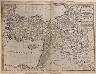
London: Laurie & Whittle, 1795. Map. Engraving. Image measures 20 1/4" x 28" Beautiful double-page map of Turkey and the Middle East, published in 1795 by D'Anville. Robert Laurie (c. 1755-1836) and James Whittle (1757-1818) were London-based map and atlas publishers active in the late 18th and early 19th century. Their firm combined Laurie's engraving skills with Whittle's social contacts and print sales experience. Together, they published numerous maps and atlases, often enlisting prominent cartographers such as Kitchin, Faden, Jefferys..... More
New York: Putnam, 1878. Translated by Caroline Tilton. iv + 326 pages, 8vo, gilt-lettered and decorated blue cloth; covers lightly worn at corners and spine ends. New York: G. P. Putnam's Sons, (1878). Fourth edition. A very good copy. More
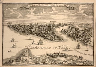
Paris: 1700. Bird's eye view, engraving, 9 3/4" x 13 3/4 " Striking birds eye view of Constantinople (Istanbul) showing the City from Calcedonia and Scutari, looking across the Thracian Bosphorus towards the Golden Horn. The waters are populated by sailing vessels. Nicolas de Fer (1646-1720) was a prolific cartographer, engraver and publisher who took over the family map business from his mother when she retired in 1687. The business flourished and he gained a great reputation in his lifetime..... More
illus. 8vo, cloth, d.w. (London): John Murray, (1964). vg. More
London: John Murray, 1964. Illustrated with b/w photos and maps. 186 pages. 8vo, blue cloth. (London): John Murray, (1964). A very good(-) copy, light sunning to spine with foxing to bottom outer edge. More
New York: Metropolitan Museum of Art, 2011. Profusely illustrated with color photos. 248 pages. Tall 4to, brown cloth, d.w. New York: Metropolitan Museum of Art, (2011). A fine copy in a fine wrapper. Inscribed by author. More
New York: Metropolitan Museum of Art, 2011. Map. 290 photographic illustrations with 265 in full-color. 264 pages. Tall 4to, brown cloth with gilt lettering at spine, pictorial d.w. New York: Metropolitan Museum of Art, (2011). Diba's inked signature and inscription at the half-title page. Large dampstain at the front endpaper and some rippling at margins of first several pages; light stains at fore-edge, otherwise a near fine copy in a near fine dust wrapper. More
New Brunswick: Rutgers University Press, 1957. Translated from the French by Naomi Walford. With an introduction and bibliography by Peter Charanis. Illustrated. xviii + 366pp., 8vo, cloth, d.w.; dust wrapper chipped. New Brunswick: Rutgers University Press, 1957. A very good copy in a very good (-) dust wrapper. More
New York: Praeger, 1963. 8vo, green cloth, d.w. New York: Praeger, (1963). Very good. More
London: Amber Books, 2012. 20 color maps, many b/w photo Illus. 4to, pictorial boards, d.w. (London): Amber Books, (2012). Very good The History of World War I. More
Istalbul: Ertug & Kocabiyik, 2000. English text by Cyril Mango Lavish color photographs of the church's 13th-century mosaics and frescoes presented in extraordinarily detailed views on large format pages. 259 pages. Large folio, beige cloth-backed iridescent green cloth, pictorial board slipcase. (Istanbul): Ertug & Kocabiyik, (2000). A fine copy. A beautiful book on the Byzantine church of Chora in Istanbul. More
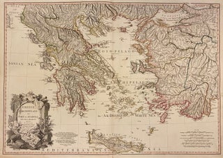
London: William Faden, 1791. Map. Engraving with original hand outline. 23" x 31" Finely engraved map of Greece and western Turkey extending from Lecce to the Black Sea, and from Macedonia to Crete. Topography is rendered my hachure in beautiful detail. Coastal features, cities, and rivers are extensively labeled. Many place names are labeled with multiple toponyms, with variations in Italian, Greek, or Turkish. Ancient place names are underlined. An elaborate title cartouche in the lower left, featuring iconography referencing..... More
Photo frontis, illus. endpapers. 8vo, cloth. New York: (1962). More
Paris: de l'Imprimerie Royale, 1819. Large copper engraved folding plan of Saint Sepulcre. Octavo, [12], 460pp. Contemporary tree calf, some scuffing barely visible. Decoratively gilt spine, red leather spine label, marbled edges. Rare text volume to accompany Forbin's illustrated atlas folio work on the Levant. Paris: de l'Imprimerie Royale, 1819. Near Fine. Forbin (1770 %u2013 1841) was Director of museums of France in 1816, a position that would allow him a year-long tour throughout the Levant, authorized to purchase antiquities..... More
San Diego: Harcourt, 1985. 8vo, 1/2 black cloth, d.w. San Diego: Harcourt Brace Jovanovich, (1985). Very good. Rome, Constantinople, Moscow. More
New York: Viking, 1967. Numerous color and black and white plates, 120 pages. Slim large 4to, cloth, d.w. (top edge ragged). New York: Studio/Viking, (1967). A near fine copy in a good dust wrapper. More
Geneva: Nagel, 1971. Produced in collaboration with the Istituto Internationale Di Arte Liturgica Rome, Chicago. Profusely illustrated in color and in black & white, maps. Tall 4to, 230 pages, blue cloth, d.w. Geneva Paris Munich: Nagel Publishers, 1971. First Edition. A fine copy. More
Berlin: Propylaen, 1925. 39 gravure plates, some colored and mounted, numerous additional photographic illus. 617pp. 4to, cloth-backed boards (rubbed), backstrip frayed at head and tail. Berlin: Propylaen, 1925. Propylean-Kunstgeschichte V. "The strength of this series lies in the illustrations which form an invaluable body of visual material." - - Arntzen/Rainwater I19. More
New York: Henry Holt, 1999. Frontispiece, map, some black & white illustrations. xv, 351 pages. 8vo, blue boards with gilt lettering at the spine, pictorial d.w., spine evenly faded. New York: Henry Holt & Co., (1999). First American edition. A fine copy in a near fine dust wrapper. More
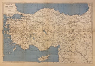
London: John Bartholomew, 1958. Map. Image measures 19" x 28 1/4". Includes accompanying sleeve published by The British Institute of Archaeology at Ankara, containing two saddle-stapled pamphlets, "Note on 'A Classical Map of Asia Minor' by W.M. Calder, 7 pages; and an index to the map by W.M. Calder and G.E. Bean, 6 pages. Clear and informative map of present-day Turkey during the Classical period, offering a comprehensive view of the region during its peak of ancient civilization. Issued with..... More
2 vols. 8vo, 1/2 morocco (worn). Stuttgart, 1889. More
Hildesheim: Olms, 1984. 2 large folding maps, folding chart, some black and white illustrations. 2 vols. in one, 545pp. + 508pp., thick 8vo, green cloth. Hildesheim: Georg Olms, 1984. Fine. A facsimile of the London 1842 edition. More
Cambridge: Harvard University Press, 1972. Profusely illustrated, some in color. 366pp. 4to, two-toned cloth. Cambridge: Harvard University Press, 1972. A very good(+) copy. More
Cambridge: Harvard University Press, 1972. Illustrated with photographs throughout, some in color. 366pp. 4to, two-toned cloth, dust wrapper, chipped and torn. Cambridge: Harvard University Press, (1972). A very good copy in a very good (-) dust wrapper. More
I have just received the copy of I, Robot Screenplay published by Easton Press and signed by Harlan Ellison which I ordered just after the middle of June 2003. The book arrived in the condition in which it was sent and I am glad that I ordered it from you. Will certainly order from Argosy Book Store again in future!
My book arrived in record time (it shocked me when it arrived so soon after ordering) and was beautifully packaged. If it didn't go via DHL it would never have made it through the Australia Post system unscathed!!! Thank you!