
Fall of the Inca Empire and the Spanish Rule in Peru: 1530-1780
New York: Scribner, 1932. Illus., folding map. 8vo, blue cloth, d.w. chipped and lightly soiled, cloth soiled, inner hinge weak, many pages wavy. New York: Scribner's 1932. More
New York: Scribner, 1932. Illus., folding map. 8vo, blue cloth, d.w. chipped and lightly soiled, cloth soiled, inner hinge weak, many pages wavy. New York: Scribner's 1932. More
map, 224 illus. 586pp. 8vo, cloth; (spines worn and repaired, otherwise very good). N.Y., 1931. Archaeology of the Incan and pre-Incan eras. Includes a 28pp. bibliography. More
5 color illus. by Marcel Floris. 36pp. 12mo, pr. wrs.; (unopened, signatures loose as published). (Caracas: Hotel Tamanaco, 1960). vg. More
Paris: Pierre Belfond, 1968. 8vo, red cloth, d.w. lightly soiled, some pencil underlining to text. Paris: Pierre Belfond, (1968). Presentation copy. More
8vo, cloth, d.w. N.Y.: Praeger, (1969). vg. More
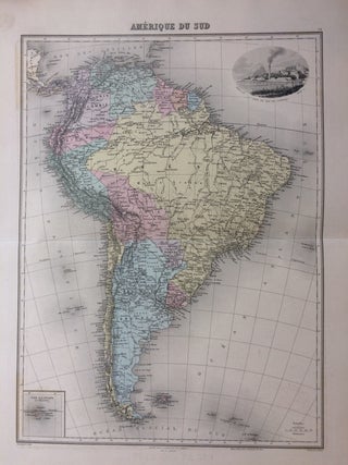
Paris: J. Migeon, 1891. Map. Engraving with original coloring. Image size 16.25 x 12.25 inches. Sheet size 20.25 x 15.25 inches. Shows some light foxing. In very good condition. From M.A. Martineau's Nouvel Atlas Illustre Geographie Universelle. Pictorial inset at top right shows Rio di Janeiro, map inset at bottom left shows the Galapagos. More
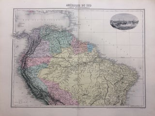
Paris: J. Migeon, 1891. Map. Engraving with original coloring. Image size 12.25 x 16.25 inches. Sheet size 15.25 x 20.25 inches. Shows some light foxing. In very good condition. From M.A. Martineau's Nouvel Atlas Illustre Geographie Universelle. Pictorial inset at top right shows Curacao. More
University of Oklahoma, 1968. Illustrated. 8vo, yellow cloth, d.w. University of Oklahoma Press, (1968). Near fine. More
Philadelphia: H. N. Burroughs, 1846. Map. Lithograph with original hand coloring. Image measures 12 3/8" x 15 1/8". This map includes the modern-day countries of Venezuela, Colombia, and Ecuador, as well as part of Panama. A large inset in the lower right corner shows a "Plan of a Proposed Communication between the Atlantic & Pacific Oceans," that is, the Panama Canal Railway. Construction on the railway would begin in 1850, only a few years after this map's 1846 publication, spurred..... More
Middletown: I. Riley, 1808. Containing copious extracts from the Araucana of Don Alonzo de Ercilla. Translated from the Original Italian, by an American Gentleman. Folding map of Chile laid in. 2 volumes. 8vo, modern blue cloth, ex-lib with a few rubberstamps in margins of both volumes, scattered light foxing to some margins of both volumes, scattered light browning to the some pages of both volumes. Middletown: I. Riley, 1808. First Edition in English. The author was born in Chile where..... More
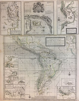
Map. Engraving with original outline coloring. Unusual business route map printed in 1720, describing the trade routes of the British South Seas Company. The firm was granted a monopoly to trade in Spain's South American colonies during the War of Spanish Succession. Speculation in the company's stock led to the South Sea Bubble in 1720. Resembling a broadside, the map includes twelve inset maps, trade winds, calm and tornado notes and many port sounding details. Repairs to margins and lined..... More
illus. 8vo, cloth, d.w. Englewood Cliffs: Prentice-Hall, (1974). Search for Inca gold. vg. More
New York: Oxford University Press, 1974. Illustrated in black and white. Frontispiece. 2 volumes. Vol I: 712 pages. Vol II: 758 pages. 8vos, yellow cloth, blue spine, slipcase. New York: Oxford University Press, 1974. Near fine--sunned at the spine-- in a near fine slipcase. Vol I: The Northern Voyages: A.D. 500-1600. Vol II: The Southern Voyages: 1292-1616. More
New York: Oxford University Press, 1974. Illustrated. xvii + 758 pages, thick 8vo, cloth, d.w.; ownership signature front free endpaper, dust wrapper price clipped, lightly rubbed. New York: Oxford University Press, 1974. A very good(+) copy in a very good dust wrapper. More
New York: Thames & Hudson, 1992. 225 illus. 4to, orange cloth, d.w. (New York): Thames and Hudson, (1992). More
8vo, cloth, d.w. Newton Abbot: David & Charles, (1973). vg. More
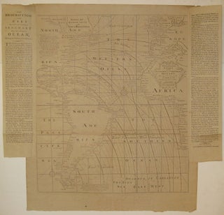
London: Mount & Davidson, Tower-Hill, 1794. Map. Uncolored engraving. Image measures 22.75" x 19.5", page including text measures 26.5" x 27 7/8". Beautiful and rare chart of the Atlantic including South America and parts of North America, Europe and Africa. Features lines of magnetic variation, or how much the compass deviates from true north. As explained in the two columns of pasted text, these observations are based upon the work of Dr. Edmond Halley in 1700 with additions in 1744..... More
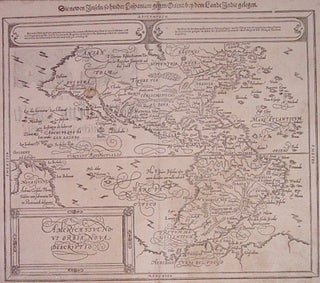
Basel: Petri, Sebastian, 1598. Map. Woodcut. Image measures 12.25" x 14.5". This rare edition published by Sebastian Petri (son of Henri) was first printed in 1588 in Munster's seminal work "Cosmographey". Based on Abraham Ortelius' map of 1570. Some minor staining along edges and in "California" More
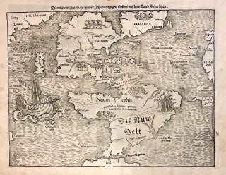
Basel: Heinrich Petri, 1572. Map. Uncolored woodcut. Sheet measures 12" x 15.25". This important and influential 1572 map by Sebastian Munster is the first map to show North America and South America in their true continental forms. It is also significant in that it names the Pacific Ocean (Mare Pacificum) and the first printed map to ever show Japan (Zipangri), here appearing based on the accounts of Marco Polo. First published in 1544 in his Basel edition of Ptolemy's "Geographia"..... More
illus., some in color. 2 vols. thick 4to, cloth; (spines lightly soiled). N.Y.: Macmillan, (1936). More
New York: Knopf, 1980. 228 pages, 8vo, black cloth, lightly edgeworn d.w. New York: Knopf, 1980. A very good(+) copy in a very good dust wrapper. More
545pp. 8vo, cloth, d.w. Princeton: Van Nostrand, (1965). vg. More
8vo, cloth, d.w. N.Y.: Knopf, 1964. vg. More
New York: James Van Norden, 1834. Report and Arguments of Counsel. G. W. Strong, Att'y for Plaintiffs, B. Robinson, Att'y for Defendants. 94pp. 8vo, sewn, some margins lightly soiled, including margins of title-page and last blank page, some pages creased in margins. Housed in a new brown cloth clamshell box with brown leather label. New York: James Van Norden, 1834. Scarce. Very good. In 1824, the ship, "China," sailed from New York to the port of Callao in Peru. Its..... More
New York: HarperCollins, 2003. Illus. 8vo, 1/2 purple cloth, d.w. (New York): HarperCollins, (2003). Fine Biography of Robert FitzRoy. More
Hello. Just a note to inform you that the book arrived in Melbourne today. It was in excellent order, as per your description. I am very pleased with the way it was packaged and the ease of the whole process. Thank you for your assistance.
Thanks for getting back to me so quickly. I wish all booksellers were as quick as you!