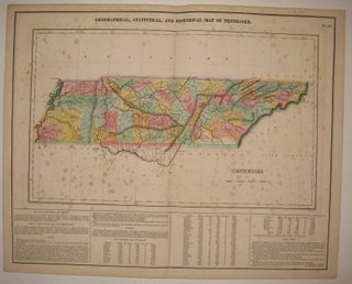
Geographical, Statistical, and Historical Map of Tennessee.
Philadelphia: Carey & Lea, 1822. Map. Engraving with original hand coloring. Image measures 11 7/8" x 10", image plus text measures 16.5" x 20 5/8". Rare double page map of Tennessee divided into counties. Shows towns, major routes, waterways and topography. Extensive information pertaining to history, climate and culture surrounds map. From "A Complete Historical, Chronological, and Geographical American Atlas...". Foxing throughout entire sheet, as is common with this map due to its placement in the atlas. Priced as is..... More