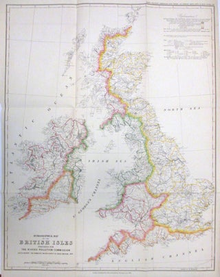
Hydrographical Map of the British Isles prepared for The Rivers Pollution Commission
London: Edward Stanford, 1874. Map. Colored engraving. Image measures 26.5 x 21". A lovely hydrographical map of the British Isles depicting England, Wales, Scotland and Ireland in incredible detail. Includes the Orkney Islands. The map shows the hydrography of the region including the system of drainage, rivers, lakes, canals and other important hydrographical features. colored lines indicate the water parting or the natural separation between rivers flowing off in opposites direction according to five great natural division of the United..... More