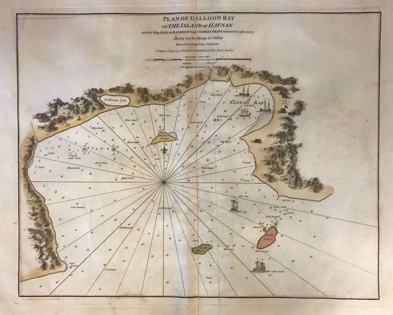
Plan of Galloon Bay on the Island of Hay-nan
London: Laurie & Whittle, 1794.
Sea chart. Hand colored copper plate engraving. Image measures 19.5" x 25".
This lovely 1794 sea chart depicts Yelong Bay or Galloon Bay on the southern coast of Hainan (Haynan), China. Rhumb lines emanate from the center of the map, spreading out in every direction toward the highly detailed coastlines of the peninsula and its surrounding islands. Xizhou (Turtle Island), Dongzhou (Rocky Island), and Yeshudao (Middle Island) are identified, as is a freshwater lake. Depth soundings are noted throughout as are sand banks and other coastal features important for navigation. Illustrations of buildings adorn the coast with ships sailing in the waters.
The map, according to the title, presents the bay where the ship 'Earl of Sandwich', under the command of Captain Charles Deane wintered in 1776 and 1777 after having lost her passage to China. Today this region is a premier resort area of Yalong Bay which boasts the finest beaches.
The map appeared in Laurie & Whittle's 1794 "Neptune Orientale." It is in good condition with full margins. Verso repairs and fills along the centerfold and bottom margins. Minor offsetting.
Robert Laurie (c. 1755 - 1836) and James Whittle (1757-1818) were London-based map and atlas publishers active in the late 18th and early 19th century. Their firm combined Laurie's engraving skills with Whittle's social contacts and print sales experience. Together, they published numerous maps and atlases, often enlisting prominent cartographers such as Kitchin, Faden, Jefferys and others to update and modify their plates. This map is a beautiful example of their work.
Binding: Unbound
Language: English
Price: $2,300.00
Item #274736