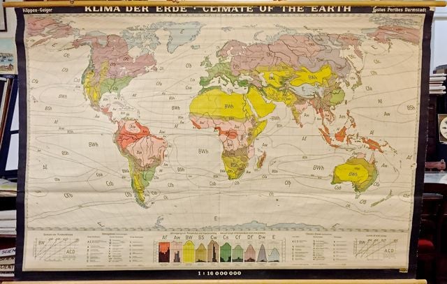
Klima der Erde / Climate of the Earth
Darmstadt: Denoyer Geppert.
Roller map with wooden rods. Color lithograph. Measures 56.6" x 83.5".
This climate map combines aesthetics and information with strikingly graphic results. It shows the world according to the Koppen Geiger climate classification system, which is one of the most commonly used modes. Each zone is appropriately colored along the spectrum of a muted rainbow in correspondence with five climate zones: tropical, dry, temperate, continental, and polar. The ocean is also divided into zones, but they are left white, such that the meandering lines of their boundaries complement the patterning created by the color. In addition, the map provides more specific information through a letter-based labeling system, printed at the bottom in both German and English, that contributes to the scientific air of the map by recalling the aesthetics of the Periodic Table of Elements. These colors and codes reappear in a series of charts showing the average temperature and precipitation of well-known cities which give the viewer, most likely a student, a more concrete sense of what common code combinations mean in practice.
The map is in good condition with some cracking and image loss around the title. Slight discoloration along the top of the map is visually offset by the brighter colors that occupy the map's center.
The publishing firm of Justus Perthes (1749-1816) was first established in 1785 and continued producing maps up through the beginning of the 21st century. Originally known for almanacs and yearbooks, the firm was nationalized by the German Democratic Republic in the 1950s and channeled its informational bent into the production of school atlases and wall maps. This map nicely conveys the rigor of their research and production.
Binding: Unbound
Language: English
Price: $265.00
Item #272362