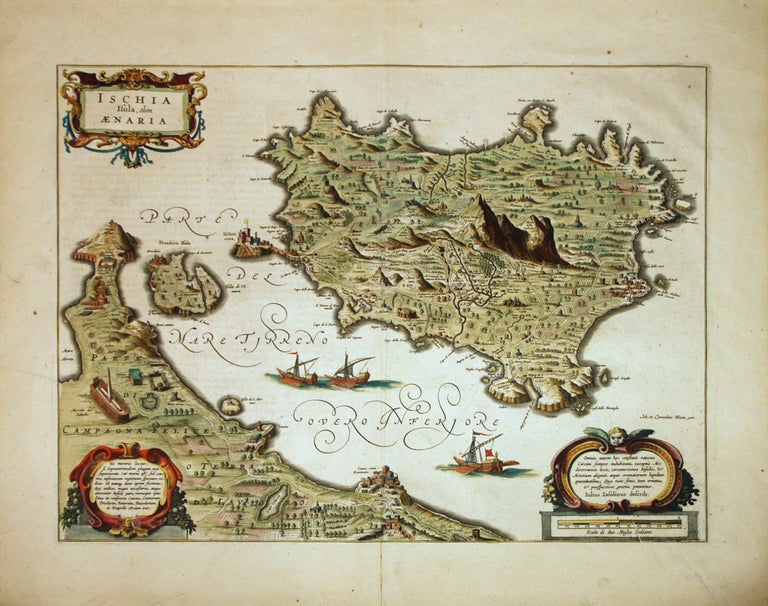
Ischia Isola, olim Aenaria
Amsterdam: Willem Blaeu.
Map. Engraving. Image measures 14.75 x 19.25".
This stunning circa 1640 map of the volcanic island of Ischia located in the Tyrrhenian Sea on the northern part of the Gulf of Naples depicts the mountainous island in exquisite detail. A combination of a map and a Bird's-eye view, it covers the island as well the coast of nearby Naples. The peninsula of Capo Miseno as well as the island of Procida are included. Oriented with north at the bottom, the map beautifully notes the various towns, cities, rivers, fields, etc. Forests and mountains are rendered in profile with the highest peak of Mount Epomeo clearly towering above the rest. Individual buildings and castles are rendered in profile, including the medieval Aragonese Castle that stands on the volcanic rocky islet that connects to the larger island of Ischia by a stone bridge. Ships are seen sailing in the Gulf of Naples.
At the time this map was issued, the Barbary Pirates operated in the region and for centuries terrorized the islanders. Many of the inhabitants ended up as slaves to the pirates.
The map includes three decorative cartouches including a beautiful title cartouche in the top left corner. The map is in very good condition with minor wear along the centerfold and some printing creases near the bottom right. Minor foxing.
Willem Blaeu (1571-1638) was a prolific Dutch mapmaker who started one of the most famous map publishing firms of the 17th century. It was at this time that the Dutch controlled the map trade, and their ornate and beautiful maps had immense popularity. Blaeu was instrumental in driving this dominance in his lifetime, and this legacy was continued by his sons. This is a beautiful example of his work.
Binding: Unbound
Price: $975.00
Item #267302