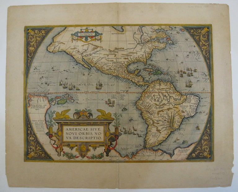
Americae Sive Novi Orbis, Nova Descriptio.
Abraham Ortelius, 1612.
Map. Engraving with hand coloring. Image measures 14" x 19.25".
This stunning 1612 map by Abraham Ortelius depicts the Western Hemisphere. At the time it was issued, the coastal areas of the New World had been fairly well explored, and Europeans were just beginning settlement and colonization. It is notable for depicting Spanish and Portuguese colonies in high detail, for these powers were notoriously protective of their geographical surveys.
This is the first state of the third plate engraved for Ortelius's landmark map of the New World. It is distinguished from the first two plates by the lack of the bulge to the southwest coast of South America. Several other cartographic enhancements are apparent on closer inspections.
The Solomon Islands are depicted here for the first time since their discovery in 1568 by Alvaro de Mendana. The map identifies several places previously unpublished due to political reasons. These were provided to Ortelius by Haklyut on the basis of recent explorations. The nomenclature in California is also included.
Perhaps the most notable enhancements on the east coast is the Indian name Wingandkoa and an inlet just above, possibly the first depiction of the Chesapeake Bay on a printed map, reflecting early English efforts at Colonization in the Outer Banks of the Carolinas.
Based on Gerard Mercators 1569 World Map, this map includes an abundance of cartographic speculation, representing the knowledge of the region during the time. The kingdom of Quivira, the supposed ancient city of gold in North America. Conquistador Francisco Vázquez de Coronado searched for Quivira for several years to finally find it was no more than American Indian settlement of farming people. Terro del Fueggo, first reached by Magellan is here shown to be part of the large speculated continent of Terra Australis that extends westward with the annotation "The southern of Magellanican land, as yet unknown".
Other interesting annotations throughout include "Somewhere here there are islands which according to some have gold", and Patagonia shows a notation that suggests its inhabitants were giants.
The waters are ornamented with illustrations of ships and a sea monster. In earlier plates, the ships are different. A large title cartouche is included in the bottom left. Another scale cartouche appears in the top left. Published in the 1612 or 1608 edition (the map is identical in both editions) of Ortelius' famous "Theatrum Orbis Terrarum," which is historically considered the first modern atlas. Based on the text on verso, only 300 copies of this particular edition were ever printed (van der Broecke 11).
Italian text on verso. Minor chipping to edges. Full original margins. Minor wear along original centerfold.
Abraham Ortelius (1527--1598), a Flemish cartographer and geographer, is widely regarded as one of the important and influential cartographers in history. He is known for his "Theatrum Orbis Terrarum," which was the first modern atlas.
Binding: Unbound
Condition: Very Good(+)
Language: English
Price: $6,500.00
Item #219257