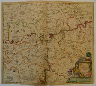
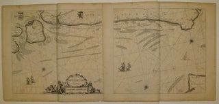
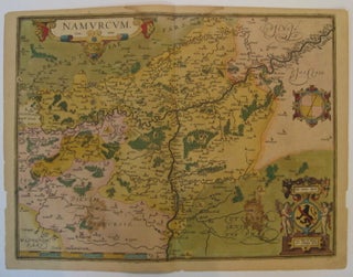
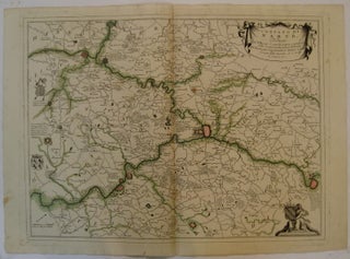
Ghent Gent Gand
Map. Lithograph. Sheet measures 23 x 15.5 inches. Shows some wear along original fold lines, otherwise in very good condition. A charming tourist map of Ghent with museums, monuments, and other sites of interest indicated. More
The Hague: Anna Beek. Map. Engraving with original hand coloring. Image measures 15 x 18". Sheet measures 21 x 25". This scarce map by Anna Beek depicts the Belgian city of Ath under attack by French troops during the Nine Years' War (1688--1697). Dating to approximately 1725, the map shows the siege of 1697, in which French troops stationed around the fortified city attempted to win it from Spanish control. The city's fortifications, walls, and surrounding moats are all depicted..... More
The Hague: Anna Beek, 1703. Map. Engraving with original hand coloring. Image measures 18 x 15". Sheet measures 25 x 21". Battle plan from 'A collection of plans of fortifications and battles', 1684-1709, depicting The War of the Spanish Succession. Chips to margins and some creases. Anna Beek was a late-17th century publisher and engraver of maps based in the Hague. Her detailed maps and battle plans are often found in composite atlases and have become highly valued due to..... More
Venice: Coronelli, Vincenzo, 1695. Map. Copper plate engraving with hand outline color. Image measures 17" x 23.25". Nice dark impression of Namur region in central Belgium. Includes several coats of arms. Handwritten in red ink "Forest de Ardennes". Small tear to lower margin. A few small scattered stains. Published by Vincenzo Coronelli (1650-1718), a Venetian map and globe maker. He obtained his Doctor of Theology in 1673 in Rome and became the cosmographer to the Republic of Venice in 1684..... More
Amsterdam. Map. Engraving with original hand color. Image measures 20" x 22.5". Beautiful map of the Namur region of Belgium. Originally published by Justus Danckerts, this is an unusual edition by his son Theodore, who inserted his own name in the title. Margins are cropped, minor scattered foxing. Tiny tear to upper left corner. More
Amsterdam. Map. Uncolored engraving. Image measures 15.5" x 20". Beautiful and unusually rendered map of Limbourg in southeastern Belgium. The Vesdre River winds around and through farmland, the hills and the fortress. Tiny scenes, houses and animals dot the landscape. Includes two coats of arms. Originally published in "Theatrum Praecipuarum Totius Europae Urbium" (town book of Europe), circa 1693. Expert repairs to centerfold, a few small tears to bottom edge. Margins have been cropped. Frederick de Wit (1629/30--1706) was one..... More
Map. Engraving with original hand coloring. Image measures 8.75" x 12". This charming map of Dunkirk shows the city as it sits on the coast of the southernmost part of the North Sea, here labeled as the Sea of Flanders. Working circa 1705, De Fer has represented the city with a schematized drawing of its exterior walls. Canals connecting the city to nearby towns and churches are also depicted and labeled. Sand bars are drawn and mountains are represented pictorically..... More
1669. Sea chart (diptych). Uncolored copperplate engraving. Each image measures 17" x 18.5". This beautiful diptych sea chart features the entire coast of Belgium with small parts of France, England, and the Netherlands. It shows the region from Calais to Nord Beveland and covers the major cities of Dunkerque and Bruges. The map includes depths, sand banks, rhumb lines, two compass roses, five decorative ships, and two coats of arms. An ornate title cartouche contains the scale and is surrounded..... More
Antwerp: Ortelius, Abraham, 1601. Map. Engraving with hand coloring. Image measures 15.5" x 20.25". Lovely map of the Namur region of Belgium. Includes a compass rose and a cartouche incorporating the Belgian coat of arms. From the 1601 Latin edition of Ortelius' "Theatrum Orbis Terrarum", the first modern Atlas. Margins have been cropped, some chipping and tears along margins. Stain to top center margin, and also to lower left and right of image. More
Senlis: Francois Ferdinand Foch, 1918. Map. Measures 24 1/4" x 22 3/8" WWI era map of Belgium and Paris. The colored part represents the extent of land reclaimed by force by the allied armies since July 18, 1918 date of the outbreak. Ferdinand Foch was a French general and military theorist who served as the Supreme Allied Commander during the First World War. More
Washington: Government Printing Office, 1916. Map. Color lithograph. 9" x 13". In very good condition. A map to accompany the article "Linguistic Barriers in Europe: their boundaries and political significance" by Leon Dominian, published in the 1915 Report of the Board of Regents of the Smithsonian Institution. The map illustrates the areas where French, Walloon, Flemish, Dutch, and German are spoken in the region, as well where French had expanded since the 13th Century. More
Amsterdam: 1681. Sea chart. Copper plate engraving with modern hand coloring. Image measures 20" x 22.75". Beautiful sea chart of the coast of Flanders, showing Bruges, part of Zeeland and part of England. Elaborate cartouche with cherubs and cornucopia. Includes rhumb lines and a compass rose. North is oriented towards bottom of page. Nicely detailed depths and banks. Minor aging and wear along edges and margins. More
The book has arrived and all is well. Thanks for a nice sale!
The Michener book arrived today in great shape!! It's what I wanted and I do appreciate your professionalism in handling this transaction for me!!! Thanks, again, and I'll look forward to any future transaction.