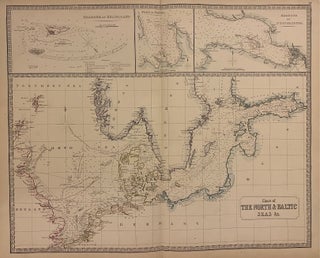
Chart of the North & Baltic Seas &c.
Edinburgh: John Thomson. Map. Engraving with original hand colored outline. Image measures 19 1/2" x 24" Impressive sea chart of the North and Baltic Seas, extending from the eastern coast of England to St. Petersburg. Includes insets of the Harbour of Heligoland, the Port of Revel, and the Harbour of St. Petersburg. Coastlines are carefully rendered, with towns and rivers labeled. Shows marine routes, sandbanks, and depths by soundings. The map is in good condition with chips and tears at..... More