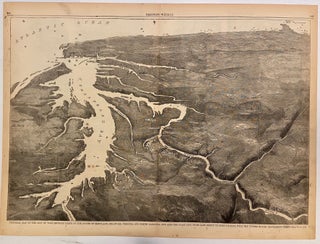
Pictorial Map of the Seat of War, Showing Parts of the States of Maryland, Delaware, Virginia, and North Carolina, and also the Coast Line From Cape Henry to Fort Pickens, with the United States Blockading Fleet
Harper & Brothers, 1861. View. Uncolored Wood engraving. Image measures 13 7/8" x 20 3/8". This double-page bird's eye view of the Chesapeake Bay region was published at the start of the Civil War. Looking southward from Maryland, the view extends along the Atlantic coast, showing the Florida panhandle in the distance. Cities are depicted pictorially, and ships are illustrated outside each major coastal city. A description on page 359 reads "We publish a large Birds-Eye View of the Seat..... More