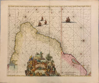
Littora Brasiliae
Amsterdam: Reiner adn Joshua Ottens. Map. Engraving with original coloring. Image 18 3/4 x 22 inches. Amsterdam: 1740. In good condition. Dynamic Dutch sea chart of Brazil with north oriented toward the left. It first appeared in De Wit's 1675 sea atlas and maps the mouth of the Amazon down to Rio de la Plata, in Argentina. Giant processional cartouche by Romeyn de Hooghe describes European encounters with the New World and is placed in SE Brazil. A Spanish conquistador..... More
![Item #243962 [Case of Large School Maps]. RAND MCNALLY, CO](https://argosybooks.cdn.bibliopolis.com/pictures/243962.jpg?width=320&height=427&fit=bounds&auto=webp&v=1375459883)
![Item #273380 [Southeast Asia]; Rare 1725 Map of East Indies and South East Asia. RENNEVILLE](https://argosybooks.cdn.bibliopolis.com/pictures/273380.jpg?width=320&height=427&fit=bounds&auto=webp&v=1487284208)
![Item #239576 [Sundial Projection World Map]. Franz RITTER](https://argosybooks.cdn.bibliopolis.com/pictures/239576.jpg?width=320&height=427&fit=bounds&auto=webp&v=1360259001)

![Item #272805 [Lemnos. Hellespont]. George SANDYS](https://argosybooks.cdn.bibliopolis.com/pictures/272805.jpg?width=320&height=427&fit=bounds&auto=webp&v=1485291158)