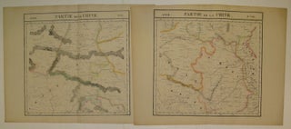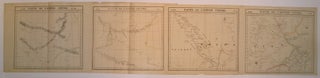
Partie de l'Empire Chinois. Asie. No. 44, 45, 46, 47.
Brussels: Vandermaelen, Phillipe Marie, 1827. Map (set of 4). Large format lithograph with original hand outline color. Each image measures 18.75" x 20 5/8", 18 5/8" x 20 5/8", 18.5" x 20 3/8", Beautifully detailed set of four regional maps of northern China and southern Mongolia. Mountains are delicately treated with hachure marks and major rivers, waterways and cities are also shown. Notable inclusions from the west to the east: Plate 44 shows the very northwestern tip of China (Xinjiang..... More