
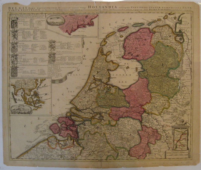
Belgii pars Septentrionalis communi nomine vulgo Hollandia nuneupata Continens Statum Potentissimae...
Amsterdam: Petrus Schenk.
Map. Engraving with original hand coloring. Image measures 18.5" x 23". Amsterdam:1705.
Unusual map of the Netherlands. Includes an array of unusual features: two inset maps of areas with Dutch VOC influence, the East Indies and a view of Batavia; and New England and Long Island, with a view of New Amsterdam. Also included is a table showing the coats of arms from the seven provinces part of the Republic of the Seven United Netherlands. Scale is displayed on a scroll, above which is a mini map hanging on its own scroll within a carved architectural niche. Map cleverly shows the southern most province, Limburg, instead of extending entire map south. Expert repairs to centerfold. Cracks from original viridean green. Chipping along edges, particularly the top and bottom. Petrus Schenk (c.1660-1711) was a German engraver and cartographer. He began his training in Amsterdam in the art of mezzotint and soon began working closely with Gerard Valck. The two took advantage of the bustling cartographic trade in the city and quickly expanded their business from portraits and prints into maps and globes. In 1700, Schenk grew the business further by moving to Leipzig, Germany and opening a shop. As his sons and grandson returned to the Netherlands to become active engravers as well, the Schenk firm developed into one of the best-known publishing houses in 18th-century Amsterdam. This map attests to Schenk's prolific production and skill in both cartographic artistry and business.
Binding: Unbound
Condition: Very Good(-)
Language: Latin
Price: $1,550.00
Item #208192